![](/images/other/stat-length.png)
- Randonnées
- Nautique
- Belgique
- Wallonie
- Namur
Namur, Wallonie, Nautique : Les meilleures randonnées, itinéraires, parcours, balades et promenades
Namur : découvrez les meilleures randonnées : 1 bateau à moteur et 3 canoë - kayak. Tous ces circuits, parcours, itinéraires et activités en plein air sont disponibles dans nos applications SityTrail pour smartphones et tablettes.
Les meilleurs parcours (4)
![Randonnée Canoë - kayak Houyet - Lesse moyenne - Photo](https://media.geolcdn.com/t/350/260/ext.jpg?maxdim=2&url=https%3A%2F%2Fmedia.geolcdn.com%2Ff%2F95cc2349-4403-471c-8117-4dc35eb31971.jpg)
![Canoë - kayak Canoë - kayak](https://static1.geolcdn.com/sitytour/trail-icons/703.png)
Km
Canoë - kayak
![](/images/other/stat-length.png)
![](https://static1.geolcdn.com/siteimages/upload/files/1508320355ic_sort_den_pos_24dp.png)
![](https://static1.geolcdn.com/siteimages/upload/files/1508320355ic_sort_den_neg_24dp.png)
![](https://static1.geolcdn.com/siteimages/upload/files/16400158638029165_repeat_loop_refresh_sync_direction_icon.png)
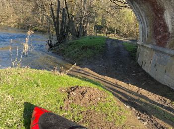
• Houyet-Wanlin le long du Ravel puis descente de la moyenne Lesse en packraft
![Randonnée Bateau à moteur Namur - Lives-sur-Meuse - Marchienne-au-Pont - Photo](https://media.geolcdn.com/t/350/260/ext.jpg?maxdim=2&url=https%3A%2F%2Fmedia.geolcdn.com%2Ff%2Fe083ee86-33bb-49ab-855f-0055a1a1d758.jpg)
![Bateau à moteur Bateau à moteur](https://static1.geolcdn.com/sitytour/trail-icons/701.png)
Km
Bateau à moteur
![](/images/other/stat-length.png)
![](https://static1.geolcdn.com/siteimages/upload/files/1508320355ic_sort_den_pos_24dp.png)
![](https://static1.geolcdn.com/siteimages/upload/files/1508320355ic_sort_den_neg_24dp.png)
![](https://static1.geolcdn.com/siteimages/upload/files/16400158638029165_repeat_loop_refresh_sync_direction_icon.png)
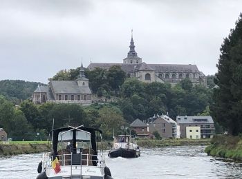
• En bateau de 12,5 m
![Randonnée Canoë - kayak Vresse-sur-Semois - Descente de la Semois namuroise en Packraft - Photo](https://media.geolcdn.com/t/350/260/ext.jpg?maxdim=2&url=https%3A%2F%2Fsecurestorage.geolives.com%2Fsitytour%2Ftrail-bg%2Fdefault.jpg)
![Canoë - kayak Canoë - kayak](https://static1.geolcdn.com/sitytour/trail-icons/703.png)
Km
Canoë - kayak
![](/images/other/stat-length.png)
![](https://static1.geolcdn.com/siteimages/upload/files/1508320355ic_sort_den_pos_24dp.png)
![](https://static1.geolcdn.com/siteimages/upload/files/1508320355ic_sort_den_neg_24dp.png)
![](https://static1.geolcdn.com/siteimages/upload/files/16400158638029165_repeat_loop_refresh_sync_direction_icon.png)
• La vallée de la Semois, vous connaissez ? Je vous emmène aujourd’hui à la découverte de sa partie namuroise. Le but d...
![Randonnée Canoë - kayak Vresse-sur-Semois - Semois - Photo](https://media.geolcdn.com/t/350/260/ext.jpg?maxdim=2&url=https%3A%2F%2Fsecurestorage.geolives.com%2Fsitytour%2Ftrail-bg%2Fdefault.jpg)
![Canoë - kayak Canoë - kayak](https://static1.geolcdn.com/sitytour/trail-icons/703.png)
Km
Canoë - kayak
![](/images/other/stat-length.png)
![](https://static1.geolcdn.com/siteimages/upload/files/1508320355ic_sort_den_pos_24dp.png)
![](https://static1.geolcdn.com/siteimages/upload/files/1508320355ic_sort_den_neg_24dp.png)
![](https://static1.geolcdn.com/siteimages/upload/files/16400158638029165_repeat_loop_refresh_sync_direction_icon.png)
4 randonnées affichées sur 4
Application GPS de randonnée GRATUITE
Activités
Régions proches
- Andenne
- Anhée
- Assesse
- Beauraing
- Bièvre
- Cerfontaine
- Ciney
- Couvin
- Dinant
- Doische
- Éghezée
- Fernelmont
- Floreffe
- Florennes
- Fosses-la-Ville
- Gedinne
- Gembloux
- Gesves
- Hamois
- Hastière
- Havelange
- Houyet
- Jemeppe-sur-Sambre
- La Bruyère
- Mettet
- Namur
- Ohey
- Onhaye
- Philippeville
- Profondeville
- Rochefort
- Sambreville
- Sombreffe
- Somme-Leuze
- Viroinval
- Vresse-sur-Semois
- Walcourt
- Yvoir