Rochefourchat, Drôme : Les meilleures randonnées, itinéraires, parcours, balades et promenades

Rochefourchat : découvrez les meilleures randonnées : 7 pédestres. Tous ces circuits, parcours, itinéraires et activités en plein air sont disponibles dans nos applications SityTrail pour smartphones et tablettes.


Les meilleurs parcours (8)

Randonnée Marche Rochefourchat - Serre Délégué depuis Rochefourchat 15 10 23 - Photo
Marche 14.349
Km

Marche

Moyen
Rochefourchat, Auvergne-Rhône-Alpes, Drôme, France
14,3 km | 25 km-effort
4h 29min
810 m
810 m
Oui
bymarc26

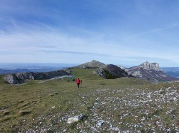
• à faire dans le sens que j'ai pratiqué Belle rando. En mai juin avec les genêts en fleur ce doit être magnifique

Randonnée Marche Rochefourchat - Grand Delmas depuis Rochefourchat - Photo
Marche 16.622
Km

Marche

Moyen
Rochefourchat, Auvergne-Rhône-Alpes, Drôme, France
16,6 km | 28 km-effort
5h 25min
867 m
872 m
Oui
ajd26

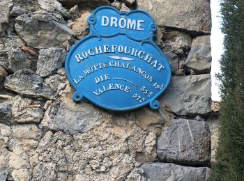
• départ de Rochefourchat (vers Pradelle) très belle randonnée à faire printemps ou automne avec des panoramas superbes...

Randonnée Marche Rochefourchat - Rochefourchat (ASPTT) - Photo
Marche 14.018
Km

Marche

Moyen
Rochefourchat, Auvergne-Rhône-Alpes, Drôme, France
14 km | 25 km-effort
5h 42min
792 m
795 m
Oui
TOULAUDIN

• trace rando enregistrée le 27/11/22 .très beau parcours pas de difficultés ,complémentaire du Grand delmas .

Randonnée A pied Rochefourchat - le grand delmas - Photo
A pied 15.912
Km

A pied

Moyen
Rochefourchat, Auvergne-Rhône-Alpes, Drôme, France
15,9 km | 27 km-effort
6h 12min
855 m
855 m
Oui
hugo26

• rando au grand Delmas depuis Rochefourchat. Cela vaut le coup .16 km pas trop difficile.

Randonnée Marche Rochefourchat - serre delègue - Photo
Marche 15.225
Km

Marche

Très difficile
Rochefourchat, Auvergne-Rhône-Alpes, Drôme, France
15,2 km | 26 km-effort
5h 43min
828 m
829 m
Oui
THIOLIER

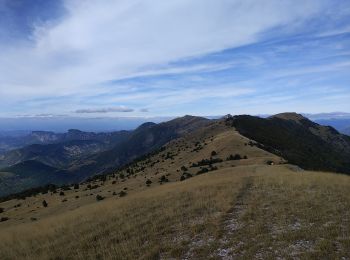
• superbes paysages en crête à 360°.

Randonnée Marche Rochefourchat - Montagne de Couspeau Rochefourchat - Photo
Marche 15.349
Km

Marche

Difficile
Rochefourchat, Auvergne-Rhône-Alpes, Drôme, France
15,3 km | 27 km-effort
Inconnu
874 m
866 m
Oui
collot

• Randonnée sympa et sans grande difficulté.

Randonnée Marche Rochefourchat - 26 - Rochefourchat - Crouspeau - 16km - 1120m - Photo
Marche 15.534
Km

Marche

Très facile
Rochefourchat, Auvergne-Rhône-Alpes, Drôme, France
15,5 km | 27 km-effort
6h 8min
876 m
869 m
Oui
django30

Randonnée sport Rochefourchat - Contournement col trepalon - Photo
sport 1.287
Km

sport

Très facile
Rochefourchat, Auvergne-Rhône-Alpes, Drôme, France
1,3 km | 2,3 km-effort
Inconnu
90 m
45 m
Non
ophness

8 randonnées affichées sur 8

Application GPS de randonnée GRATUITE

Logo SityTrail SityTrail

IGN / Instituts géographiques

Télécharger SityTrail sur l'App Store Télécharger SityTrail sur Google Play

Logo SityTrail SityTrail World

Le monde est à vous

Télécharger SityTrail sur l'App Store Télécharger SityTrail sur Google Play Télécharger SityTrail sur Huawei AppGallery

Activités

Fermer
Mes abonnements