Randonnée Marche Rochefourchat - Serre Délégué depuis Rochefourchat 15 10 23 - Photo

Serre Délégué depuis Rochefourchat 15 10 23

 bymarc26
bymarc26

Utilisateur

© OpenStreetMap contributors
Longueur
Longueur
14,3 km
Altitude max
Altitude max
1469 m
Dénivelé positif
Dénivelé positif
810 m
Km-Effort
Km-Effort  
25 km
Altitude min
Altitude min
840 m
Dénivelé négatif
Dénivelé négatif
810 m
Boucle
Boucle
Oui
Date de création :
2023-10-15 07:29:51.996
Dernière modification :
2023-10-17 09:35:58.992

(0 Avis)

Marche
Marche
4h29
Difficulté : Moyen

Scannez ce code QR pour ouvrir la randonnée dans l'application SityTrail

Application GPS de randonnée GRATUITE

Logo SityTrail SityTrail

IGN / Instituts géographiques

Télécharger SityTrail sur l'App Store Télécharger SityTrail sur Google Play

Logo SityTrail SityTrail World

Le monde est à vous

Télécharger SityTrail sur l'App Store Télécharger SityTrail sur Google Play Télécharger SityTrail sur Huawei AppGallery

À propos

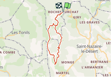
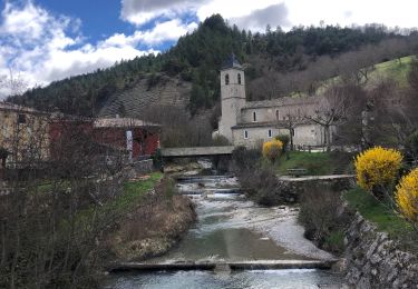
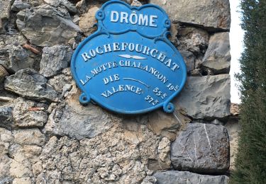
Randonnée Marche de 14,3 km à découvrir à Auvergne-Rhône-Alpes, Drôme, Rochefourchat. Cette randonnée est proposée par bymarc26.

Description

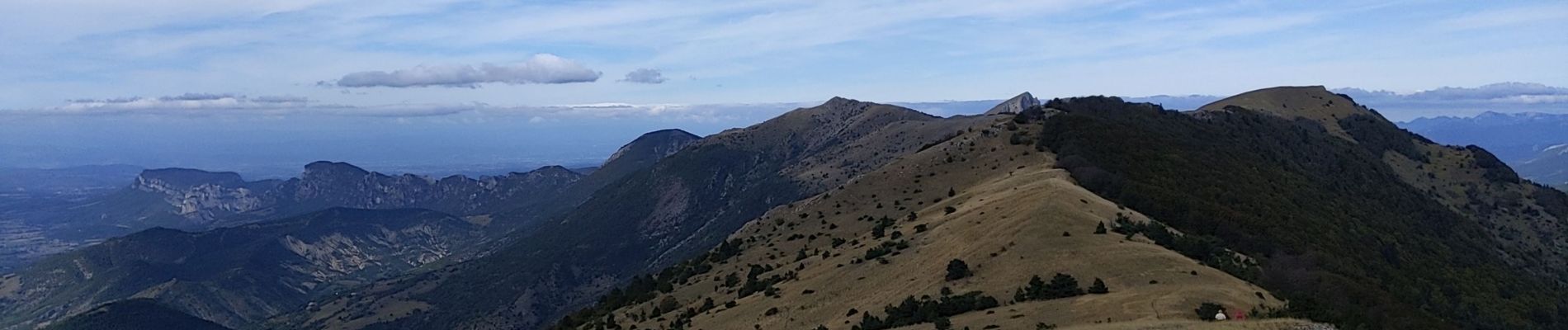
à faire dans le sens que j'ai pratiqué
Belle rando. En mai juin avec les genêts en fleur ce doit être magnifique

Profil altimétrique

Photos

Localisation

Pays :
France
Région :
Auvergne-Rhône-Alpes
Département/Province :
Drôme
Commune :
Rochefourchat
Localité :
Unknown
Départ:(UTM)
678319 ; 4940759 (31T) N.

Randonnées à proximité

Randonnée Marche La Chaudière - Les 3 Becs - Photo
Marche
Noiraude

Marche

Moyen
(1)
La Chaudière, Auvergne-Rhône-Alpes, Drôme, France
10,3 km | 21 km-effort
5h 37min
Oui
Randonnée Marche La Chaudière - La chaudiere - chapelle des Sadoux - Photo
Marche
bob2023

Marche

Très facile
(2)
La Chaudière, Auvergne-Rhône-Alpes, Drôme, France
11,1 km | 18,2 km-effort
3h 47min
Oui
Randonnée Marche La Chaudière - les trois becs - Photo
Marche
GUIDE
amiral13

Marche

Moyen
La Chaudière, Auvergne-Rhône-Alpes, Drôme, France
11,7 km | 23 km-effort
6h 25min
Oui
Randonnée Marche Saint-Nazaire-le-Désert - Bergerie du Pradaux - Photo
Marche
yvon26

Marche

Moyen
(1)
Saint-Nazaire-le-Désert, Auvergne-Rhône-Alpes, Drôme, France
12,5 km | 22 km-effort
4h 42min
Oui
Randonnée Marche La Chaudière - 070823 Boucle des 3 Becs - Photo
Marche
mzonzon05

Marche

Très difficile
La Chaudière, Auvergne-Rhône-Alpes, Drôme, France
11,4 km | 23 km-effort
4h 58min
Oui
Randonnée Marche Saint-Nazaire-le-Désert - Saint Nazaire le Désert  - Photo
Marche
alinetpierre

Marche

Facile
Saint-Nazaire-le-Désert, Auvergne-Rhône-Alpes, Drôme, France
12,4 km | 21 km-effort
3h 44min
Oui
Randonnée Marche Rochefourchat - Grand Delmas depuis Rochefourchat - Photo
Marche
ajd26

Marche

Moyen
Rochefourchat, Auvergne-Rhône-Alpes, Drôme, France
16,6 km | 28 km-effort
5h 25min
Oui
Randonnée Marche Saint-Nazaire-le-Désert - St Nazaire le Désert Bergerie des Pradaux - Photo
Marche
Indi34

Marche

Moyen
Saint-Nazaire-le-Désert, Auvergne-Rhône-Alpes, Drôme, France
10,1 km | 17,7 km-effort
4h 0min
Oui
Randonnée Marche Rochefourchat - Rochefourchat (ASPTT) - Photo
Marche
TOULAUDIN

Marche

Moyen
Rochefourchat, Auvergne-Rhône-Alpes, Drôme, France
14 km | 25 km-effort
5h 42min
Oui


Fermer
Mes abonnements