Eaux-Puiseaux, Aube : Les meilleures randonnées, itinéraires, parcours, balades et promenades

Eaux-Puiseaux : découvrez les meilleures randonnées : 12 pédestres. Tous ces circuits, parcours, itinéraires et activités en plein air sont disponibles dans nos applications SityTrail pour smartphones et tablettes.


Les meilleurs parcours (12)

Randonnée Marche Eaux-Puiseaux - Circuit des trois Monts - Eaux-Puiseaux - Photo
Marche 14.714
Km

Marche

Très difficile
Eaux-Puiseaux, Grand Est, Aube, France
14,7 km | 19 km-effort
3h 45min
320 m
321 m
Oui
tracegps

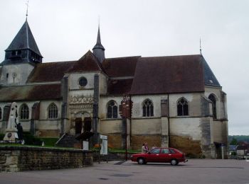
• Circuit proposé par l’Office du Tourisme du Chaourçois en Pays d’Armance. Départ de la « Ferme du clocher » à Eaux-Pu...

Randonnée Marche Eaux-Puiseaux - eau p - Photo
Marche 21.53
Km

Marche

Facile
Eaux-Puiseaux, Grand Est, Aube, France
22 km | 28 km-effort
6h 22min
491 m
487 m
Oui
maraisch

• eaux. p21

Randonnée Marche Eaux-Puiseaux - Eaux puiseaux - Photo
Marche 11.931
Km

Marche

Facile
Eaux-Puiseaux, Grand Est, Aube, France
11,9 km | 14,8 km-effort
3h 4min
212 m
212 m
Oui
richardetchantal

• rando facile

Randonnée Marche nordique Eaux-Puiseaux - circuit au départ de Eaux-Puiseaux - Photo
Marche nordique 7.336
Km

Marche nordique

Facile
Eaux-Puiseaux, Grand Est, Aube, France
7,3 km | 10 km-effort
1h 17min
202 m
202 m
Oui
choubaka77

• Circuit sympathique avec un peu de relief pour se challenger

Randonnée Marche Eaux-Puiseaux - d'eaux. Puiseaux. 32. borne  - Photo
Marche 31.336
Km

Marche

Moyen
Eaux-Puiseaux, Grand Est, Aube, France
31 km | 39 km-effort
9h 47min
614 m
603 m
Non
maraisch

Randonnée Marche nordique Eaux-Puiseaux - Eau-Puiseaux à Roffey - Photo
Marche nordique 32.283
Km

Marche nordique

Difficile
Eaux-Puiseaux, Grand Est, Aube, France
32 km | 37 km-effort
6h 49min
326 m
362 m
Non
BOUMA

Randonnée Marche Eaux-Puiseaux - Eaux Puiseaux 12.3km réel - Photo
Marche 12.346
Km

Marche

Difficile
Eaux-Puiseaux, Grand Est, Aube, France
12,3 km | 15,7 km-effort
3h 28min
252 m
252 m
Oui
rando-nico

Randonnée Marche Eaux-Puiseaux - Eaux Puiseaux  - Photo
Marche 11.537
Km

Marche

Difficile
Eaux-Puiseaux, Grand Est, Aube, France
11,5 km | 14,8 km-effort
2h 33min
248 m
250 m
Oui
MoiClaude

Randonnée Marche Eaux-Puiseaux - Eaux-Puiseaux 12km réel - Photo
Marche 12.098
Km

Marche

Très facile
Eaux-Puiseaux, Grand Est, Aube, France
12,1 km | 14,6 km-effort
3h 5min
185 m
185 m
Oui
rando-nico

Randonnée Marche Eaux-Puiseaux - eaux puiseaux 4 sept 2019 - Photo
Marche 11.781
Km

Marche

Très facile
Eaux-Puiseaux, Grand Est, Aube, France
11,8 km | 14,8 km-effort
3h 2min
226 m
223 m
Oui
yasujiro10

Randonnée Marche Eaux-Puiseaux - Eaux-Puiseaux 15km le 12-03-2019 - Photo
Marche 15.348
Km

Marche

Moyen
Eaux-Puiseaux, Grand Est, Aube, France
15,3 km | 18,8 km-effort
2h 55min
258 m
258 m
Oui
francis1952

Randonnée Marche Eaux-Puiseaux - Eaux Puiseaux 10.1km réel - Photo
Marche 10.064
Km

Marche

Très facile
Eaux-Puiseaux, Grand Est, Aube, France
10,1 km | 13,2 km-effort
2h 49min
234 m
235 m
Oui
rando-nico

12 randonnées affichées sur 12

Application GPS de randonnée GRATUITE

Logo SityTrail SityTrail

IGN / Instituts géographiques

Télécharger SityTrail sur l'App Store Télécharger SityTrail sur Google Play

Logo SityTrail SityTrail World

Le monde est à vous

Télécharger SityTrail sur l'App Store Télécharger SityTrail sur Google Play Télécharger SityTrail sur Huawei AppGallery

Activités

Fermer
Mes abonnements