Baerenthal, Moselle : Les meilleures randonnées, itinéraires, parcours, balades et promenades

3 commentaires

Baerenthal : découvrez les meilleures randonnées : 28 pédestres, 4 à vélo ou VTT et 6 parcours équestres. Tous ces circuits, parcours, itinéraires et activités en plein air sont disponibles dans nos applications SityTrail pour smartphones et tablettes.


Les meilleurs parcours (40)

Randonnée A pied Baerenthal - Anneau jaune - Photo
A pied 12.278
Km
PRO

A pied

Facile
Baerenthal, Grand Est, Moselle, France
12,3 km | 15,3 km-effort
3h 28min
227 m
229 m
Oui
SityTrail - itinéraires balisés pédestres

• Randonnée créée par Club vosgien Baerenthal. Symbole: yellow circle with white dot in the middle

Randonnée A pied Baerenthal - Anneau rouge - Photo
A pied 5.427
Km
PRO

A pied

Facile
Baerenthal, Grand Est, Moselle, France
5,4 km | 7,6 km-effort
1h 43min
160 m
164 m
Oui
SityTrail - itinéraires balisés pédestres

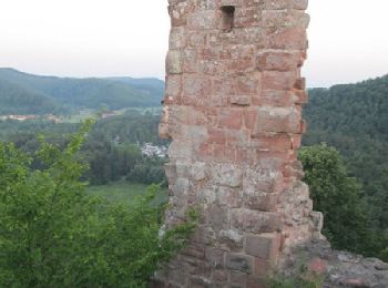
• Randonnée créée par Club vosgien Baerenthal. Follows the GR 532 from the crossroads north to the Ramstein Castle to ...

Randonnée A pied Baerenthal - Anneau bleu - Photo
A pied 6.233
Km
PRO

A pied

Facile
Baerenthal, Grand Est, Moselle, France
6,2 km | 9,1 km-effort
2h 4min
214 m
220 m
Oui
SityTrail - itinéraires balisés pédestres

• Randonnée créée par Club vosgien Baerenthal. Follows the GR 532 from Baerenthal to the Wolfskaul. Symbole: blue cir...

Randonnée A pied Baerenthal - Anneau vert - Photo
A pied 7.699
Km
PRO

A pied

Facile
Baerenthal, Grand Est, Moselle, France
7,7 km | 10,7 km-effort
2h 26min
225 m
236 m
Oui
SityTrail - itinéraires balisés pédestres

• Randonnée créée par Club vosgien Baerenthal. Follows the GR 532 from the Little Dunkelthal pass to Baerenthal. Symb...

Randonnée A pied Baerenthal - Rectangle jaune-blanc-jaune - Photo
A pied 3.747
Km
PRO

A pied

Facile
Baerenthal, Grand Est, Moselle, France
3,7 km | 4,5 km-effort
1h 0min
48 m
73 m
Non
SityTrail - itinéraires balisés pédestres

• Randonnée créée par Club vosgien Baerenthal. This is the former GR 532 route = route formerly marked by a yellow rec...

Randonnée A pied Baerenthal - Disque jaune - Photo
A pied 7.177
Km
PRO

A pied

Facile
Baerenthal, Grand Est, Moselle, France
7,2 km | 9,3 km-effort
2h 6min
140 m
203 m
Non
SityTrail - itinéraires balisés pédestres

• Randonnée créée par Club vosgien Baerenthal. Symbole: yellow dot Site web: https://ignrando.fr/fr/parcours/28149-3...

Randonnée Marche Baerenthal - Baerenthal - Photo
Marche 14.371
Km

Marche

Moyen
(1)
Baerenthal, Grand Est, Moselle, France
14,4 km | 18,7 km-effort
4h 22min
320 m
327 m
Oui
VacheKiri67

• Faite le 30/03/2018 avec notre fils Théo de 13 ans et nos amis régionaux de l'étape Eléonore et Bernard.

Randonnée Marche Baerenthal - Baerenthal - Ruines du Ramstein - Photo
Marche 5.636
Km

Marche

Facile
(1)
Baerenthal, Grand Est, Moselle, France
5,6 km | 8 km-effort
1h 28min
175 m
179 m
Oui
VacheKiri67

• Faite le 31/12/2015 avec notre fils de 11 ans et notre ami Bernard le régional de l'étape.

Randonnée Marche Baerenthal - Baerenthal, château de Ramstein de nuit - Photo
Marche 19.479
Km

Marche

Moyen
Baerenthal, Grand Est, Moselle, France
19,5 km | 26 km-effort
5h 30min
477 m
474 m
Oui
tracegps

• Marche de nuit, 20 juillet, du coucher au lever du soleil. Rendez-vous à 23h, sur le Parking devant la chapelle Notre...

Randonnée Marche Baerenthal - schmalenthal, bannstein, hammerschless - Photo
Marche 7.634
Km

Marche

Facile
Baerenthal, Grand Est, Moselle, France
7,6 km | 10,1 km-effort
2h 0min
188 m
184 m
Oui
BernardAF

Randonnée Marche Baerenthal - muhlthal route brambach Schwartzenberg  - Photo
Marche 12.161
Km

Marche

Facile
Baerenthal, Grand Est, Moselle, France
12,2 km | 16,3 km-effort
3h 55min
311 m
311 m
Oui
BernardAF

Randonnée Marche Baerenthal - Baerenthal  - Photo
Marche 9.68
Km

Marche

Facile
Baerenthal, Grand Est, Moselle, France
9,7 km | 13,2 km-effort
2h 49min
267 m
261 m
Oui
BernardAF

Randonnée Marche Baerenthal - Grand-Arnsbourg - Photo
Marche 12.553
Km

Marche

Facile
Baerenthal, Grand Est, Moselle, France
12,6 km | 17,6 km-effort
5h 9min
374 m
378 m
Oui
Claudele

Randonnée V.T.T. Baerenthal - 20220415 - Photo
V.T.T. 24.752
Km

V.T.T.

Difficile
Baerenthal, Grand Est, Moselle, France
25 km | 34 km-effort
1h 57min
668 m
668 m
Oui
fredodlageo

• sortie vtt

Randonnée Marche Baerenthal - 20200222 - Photo
Marche 10.049
Km

Marche

Baerenthal, Grand Est, Moselle, France
10 km | 13,2 km-effort
2h 27min
236 m
243 m
Oui
fredodlageo

• Rando Izzie

Randonnée Marche Baerenthal - Arnsbourg - Photo
Marche 20.934
Km

Marche

Moyen
Baerenthal, Grand Est, Moselle, France
21 km | 30 km-effort
6h 7min
646 m
751 m
Non
edouard_bieber

• 16.05.2014

Randonnée Marche Baerenthal - Baerenthal - Photo
Marche 12.015
Km

Marche

Facile
(1)
Baerenthal, Grand Est, Moselle, France
12 km | 16,9 km-effort
3h 40min
368 m
367 m
Oui
gilbraun67150

• Départ Ramstein plage,Fischerhof,Col du pt Dunkeithal, col du grd Dunkeithal, château de Ramstein

Randonnée Randonnée équestre Baerenthal - Balade château du Falkenstein  - Photo
Randonnée équestre 17.909
Km

Randonnée équestre

Moyen
Baerenthal, Grand Est, Moselle, France
17,9 km | 23 km-effort
2h 32min
407 m
412 m
Oui
Domlouise

Randonnée Randonnée équestre Baerenthal - OPTION 2 Baerenthal-Lembach - Photo
Randonnée équestre 28.445
Km

Randonnée équestre

Difficile
Baerenthal, Grand Est, Moselle, France
28 km | 38 km-effort
5h 2min
731 m
751 m
Non
maureengeorges

Randonnée Randonnée équestre Baerenthal - Option 1 Baerenthal-Lembach - Photo
Randonnée équestre 30.191
Km

Randonnée équestre

Difficile
Baerenthal, Grand Est, Moselle, France
30 km | 40 km-effort
5h 13min
711 m
735 m
Non
maureengeorges

20 randonnées affichées sur 40

Application GPS de randonnée GRATUITE

Logo SityTrail SityTrail

IGN / Instituts géographiques

Télécharger SityTrail sur l'App Store Télécharger SityTrail sur Google Play

Logo SityTrail SityTrail World

Le monde est à vous

Télécharger SityTrail sur l'App Store Télécharger SityTrail sur Google Play Télécharger SityTrail sur Huawei AppGallery

Activités

Fermer
Mes abonnements