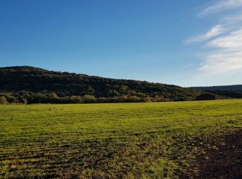
![](/images/other/stat-length.png)
- Randonnées
- Outdoor
- France
- Occitanie
- Hérault
Hérault, Occitanie : Les meilleures randonnées, itinéraires, parcours, balades et promenades
Hérault : découvrez les meilleures randonnées : 5 959 pédestres, 1 109 à vélo ou VTT et 43 parcours équestres. Tous ces circuits, parcours, itinéraires et activités en plein air sont disponibles dans nos applications SityTrail pour smartphones et tablettes.
Les meilleurs parcours (7511)
![Randonnée Marche Le Pouget - Randonnée du dolmen de Pouget et plus - Photo](https://media.geolcdn.com/t/350/260/ext.jpg?maxdim=2&url=https%3A%2F%2Fservices.sitytrail.com%2FGeolivesWS%2FDownloadMedia.ashx%3FTrailID%3D227927%26Media%3D20131019153354.jpg)
![Marche Marche](https://static1.geolcdn.com/sitytour/trail-icons/101.png)
Km
Marche
![](/images/other/stat-length.png)
![](https://static1.geolcdn.com/siteimages/upload/files/1508320355ic_sort_den_pos_24dp.png)
![](https://static1.geolcdn.com/siteimages/upload/files/1508320355ic_sort_den_neg_24dp.png)
![](https://static1.geolcdn.com/siteimages/upload/files/16400158638029165_repeat_loop_refresh_sync_direction_icon.png)
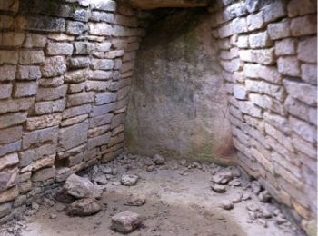
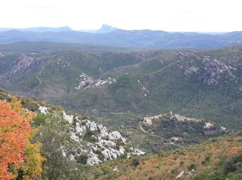
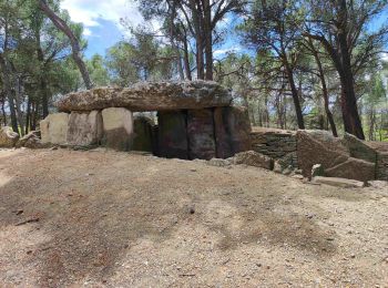
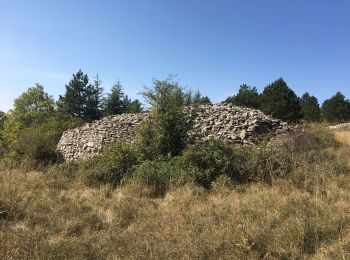
• Dolmen, vignes, forêt, cyste, anis, thym, olivier etc
![Randonnée V.T.T. Balaruc-le-Vieux - Tour Etang du Thau - Balaruc le Vieux - Photo](https://media.geolcdn.com/t/350/260/ext.jpg?maxdim=2&url=https%3A%2F%2Fservices.sitytrail.com%2FGeolivesWS%2FDownloadMedia.ashx%3FTrailID%3D129635%26Media%3D13155_4.jpg)
![V.T.T. V.T.T.](https://static1.geolcdn.com/sitytour/trail-icons/202.png)
Km
V.T.T.
![](/images/other/stat-length.png)
![](https://static1.geolcdn.com/siteimages/upload/files/1508320355ic_sort_den_pos_24dp.png)
![](https://static1.geolcdn.com/siteimages/upload/files/1508320355ic_sort_den_neg_24dp.png)
![](https://static1.geolcdn.com/siteimages/upload/files/16400158638029165_repeat_loop_refresh_sync_direction_icon.png)
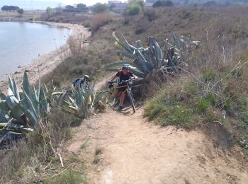
• Départ par la voie verte, corniche de Balaruc les Bains, corniche de Séte, voie verte Sète Marseillan, petit tour dan...
![Randonnée Marche Cesseras - Grotte Aldène Cesseras - Photo](https://media.geolcdn.com/t/350/260/ext.jpg?maxdim=2&url=https%3A%2F%2Fmedia.geolcdn.com%2Ff%2Ffbc77cc8-93f1-4b6b-b038-073024d6a586.jpg)
![Marche Marche](https://static1.geolcdn.com/sitytour/trail-icons/101.png)
Km
Marche
![](/images/other/stat-length.png)
![](https://static1.geolcdn.com/siteimages/upload/files/1508320355ic_sort_den_pos_24dp.png)
![](https://static1.geolcdn.com/siteimages/upload/files/1508320355ic_sort_den_neg_24dp.png)
![](https://static1.geolcdn.com/siteimages/upload/files/16400158638029165_repeat_loop_refresh_sync_direction_icon.png)
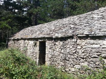
• Très chouette. Descendre au moulin, visiter la grotte. Prendre le petit chemin à droite en contrebas de la falaise, e...
![Randonnée Marche Laroque - Le Thaurac - Photo](https://media.geolcdn.com/t/350/260/ext.jpg?maxdim=2&url=https%3A%2F%2Fmedia.geolcdn.com%2Ff%2F30b167b1-5f63-4ec1-8145-7995590d63c1.jpg)
![Marche Marche](https://static1.geolcdn.com/sitytour/trail-icons/101.png)
Km
Marche
![](/images/other/stat-length.png)
![](https://static1.geolcdn.com/siteimages/upload/files/1508320355ic_sort_den_pos_24dp.png)
![](https://static1.geolcdn.com/siteimages/upload/files/1508320355ic_sort_den_neg_24dp.png)
![](https://static1.geolcdn.com/siteimages/upload/files/16400158638029165_repeat_loop_refresh_sync_direction_icon.png)
• au départ de Laroque
![Randonnée Marche Pégairolles-de-Buèges - Seranne Pontel - Photo](https://media.geolcdn.com/t/350/260/ext.jpg?maxdim=2&url=https%3A%2F%2Fmedia.geolcdn.com%2Ff%2F29a3d2a0-e263-4feb-8b8a-8f793f3452c4.jpg)
![Marche Marche](https://static1.geolcdn.com/sitytour/trail-icons/101.png)
Km
Marche
![](/images/other/stat-length.png)
![](https://static1.geolcdn.com/siteimages/upload/files/1508320355ic_sort_den_pos_24dp.png)
![](https://static1.geolcdn.com/siteimages/upload/files/1508320355ic_sort_den_neg_24dp.png)
![](https://static1.geolcdn.com/siteimages/upload/files/16400158638029165_repeat_loop_refresh_sync_direction_icon.png)
• depart le Mejanel
![Randonnée Marche Saint-Étienne-de-Gourgas - St Etienne de Gourgas - col de Melanque - Puech haut - Photo](https://media.geolcdn.com/t/350/260/ext.jpg?maxdim=2&url=https%3A%2F%2Fservices.sitytrail.com%2FGeolivesWS%2FDownloadMedia.ashx%3FTrailID%3D334032%26Media%3Decee9542-ae6c-4b78-860f-f4fbe993ce14.jpg)
![Marche Marche](https://static1.geolcdn.com/sitytour/trail-icons/101.png)
Km
Marche
![](/images/other/stat-length.png)
![](https://static1.geolcdn.com/siteimages/upload/files/1508320355ic_sort_den_pos_24dp.png)
![](https://static1.geolcdn.com/siteimages/upload/files/1508320355ic_sort_den_neg_24dp.png)
![](https://static1.geolcdn.com/siteimages/upload/files/16400158638029165_repeat_loop_refresh_sync_direction_icon.png)
• Très belle rando au départ du parking des Tennis de St Etienne de Gourgas vers le col et la serre de Melanque puis le...
![Randonnée Marche nordique Joncels - Joncels Circuit archéologique FFRP - Photo](https://media.geolcdn.com/t/350/260/ext.jpg?maxdim=2&url=https%3A%2F%2Fmedia.geolcdn.com%2Ff%2F0eb6a312-d62e-40e4-973b-25f789da995e.png)
![Marche nordique Marche nordique](https://static1.geolcdn.com/sitytour/trail-icons/102.png)
Km
Marche nordique
![](/images/other/stat-length.png)
![](https://static1.geolcdn.com/siteimages/upload/files/1508320355ic_sort_den_pos_24dp.png)
![](https://static1.geolcdn.com/siteimages/upload/files/1508320355ic_sort_den_neg_24dp.png)
![](https://static1.geolcdn.com/siteimages/upload/files/16400158638029165_repeat_loop_refresh_sync_direction_icon.png)
• Un parcours très agréable, empruntant tantôt de larges pistes forestières, tantôt de petits sentiers en sous-bois, av...
![Randonnée Marche nordique Lauroux - Labeil - Forêt de l'Escandorgue en marche nordique - Photo](https://media.geolcdn.com/t/350/260/ext.jpg?maxdim=2&url=https%3A%2F%2Fmedia.geolcdn.com%2Ff%2Fc2282928-f752-4149-927b-0f9ea4e169ca.jpg)
![Marche nordique Marche nordique](https://static1.geolcdn.com/sitytour/trail-icons/102.png)
Km
Marche nordique
![](/images/other/stat-length.png)
![](https://static1.geolcdn.com/siteimages/upload/files/1508320355ic_sort_den_pos_24dp.png)
![](https://static1.geolcdn.com/siteimages/upload/files/1508320355ic_sort_den_neg_24dp.png)
![](https://static1.geolcdn.com/siteimages/upload/files/16400158638029165_repeat_loop_refresh_sync_direction_icon.png)
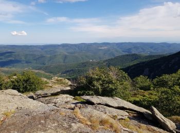
• La forêt domaniale de l'Escandorgue constitue la destination idéale pour la randonnée et la marche nordique en toute ...
![Randonnée Marche Le Bosc - Saint-Alban - Célis - La Roque - Photo](https://media.geolcdn.com/t/350/260/ext.jpg?maxdim=2&url=https%3A%2F%2Fmedia.geolcdn.com%2Ff%2F932d7dea-57ce-4b8a-b586-1c6511489398.jpg)
![Marche Marche](https://static1.geolcdn.com/sitytour/trail-icons/101.png)
Km
Marche
![](/images/other/stat-length.png)
![](https://static1.geolcdn.com/siteimages/upload/files/1508320355ic_sort_den_pos_24dp.png)
![](https://static1.geolcdn.com/siteimages/upload/files/1508320355ic_sort_den_neg_24dp.png)
![](https://static1.geolcdn.com/siteimages/upload/files/16400158638029165_repeat_loop_refresh_sync_direction_icon.png)
• Étant sorti de l'A75 sur la D144E2, on arrive à Saint-Martin (Le Bosc) où l'on prend à droite la D153E3 vers Saint-Al...
![Randonnée Marche Lunas - Laval de Nize - Briandes - ND de Nize - Photo](https://media.geolcdn.com/t/350/260/ext.jpg?maxdim=2&url=https%3A%2F%2Fmedia.geolcdn.com%2Ff%2Fa871bb29-ae4b-4227-a102-498b734b8914.jpg)
![Marche Marche](https://static1.geolcdn.com/sitytour/trail-icons/101.png)
Km
Marche
![](/images/other/stat-length.png)
![](https://static1.geolcdn.com/siteimages/upload/files/1508320355ic_sort_den_pos_24dp.png)
![](https://static1.geolcdn.com/siteimages/upload/files/1508320355ic_sort_den_neg_24dp.png)
![](https://static1.geolcdn.com/siteimages/upload/files/16400158638029165_repeat_loop_refresh_sync_direction_icon.png)
• En venant de Lodève, sur la route de Lunas (D35), on franchit le col de la Baraque de Bral et on continue, à gauche, ...
![Randonnée Marche Cesseras - Cesseras 12 kms - Photo](https://media.geolcdn.com/t/350/260/ext.jpg?maxdim=2&url=https%3A%2F%2Fmedia.geolcdn.com%2Ff%2F63ef11e1-9828-4e19-8811-ad8eeda1adef.jpg)
![Marche Marche](https://static1.geolcdn.com/sitytour/trail-icons/101.png)
Km
Marche
![](/images/other/stat-length.png)
![](https://static1.geolcdn.com/siteimages/upload/files/1508320355ic_sort_den_pos_24dp.png)
![](https://static1.geolcdn.com/siteimages/upload/files/1508320355ic_sort_den_neg_24dp.png)
![](https://static1.geolcdn.com/siteimages/upload/files/16400158638029165_repeat_loop_refresh_sync_direction_icon.png)
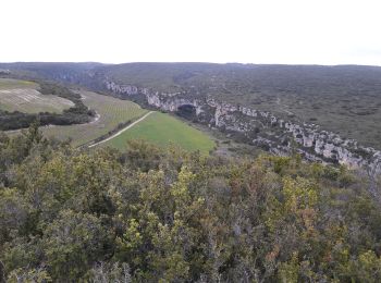
• belle randonnée dominant des gorges de la Cesse ;après la rando arrêter vous au superbe dolmen des Fados, vieux de 5...
![Randonnée Marche nordique Mérifons - Malavieille - Montagne de la Boutine - Photo](https://media.geolcdn.com/t/350/260/ext.jpg?maxdim=2&url=https%3A%2F%2Fmedia.geolcdn.com%2Ff%2F8aab6b2b-89ba-4093-96e5-b63d668fdd27.jpg)
![Marche nordique Marche nordique](https://static1.geolcdn.com/sitytour/trail-icons/102.png)
Km
Marche nordique
![](/images/other/stat-length.png)
![](https://static1.geolcdn.com/siteimages/upload/files/1508320355ic_sort_den_pos_24dp.png)
![](https://static1.geolcdn.com/siteimages/upload/files/1508320355ic_sort_den_neg_24dp.png)
![](https://static1.geolcdn.com/siteimages/upload/files/16400158638029165_repeat_loop_refresh_sync_direction_icon.png)
• En venant d'Octon, sur la route départementale D8E3, environ 500 m après le hameau de Malavieille (commune de Mérifon...
![Randonnée Marche nordique Lodève - Chemin des Tines - La Défriche - Belbezet - Montifort - Photo](https://media.geolcdn.com/t/350/260/ext.jpg?maxdim=2&url=https%3A%2F%2Fmedia.geolcdn.com%2Ff%2F5db620f0-9bce-46db-b4f7-036de46feabc.jpg)
![Marche nordique Marche nordique](https://static1.geolcdn.com/sitytour/trail-icons/102.png)
Km
Marche nordique
![](/images/other/stat-length.png)
![](https://static1.geolcdn.com/siteimages/upload/files/1508320355ic_sort_den_pos_24dp.png)
![](https://static1.geolcdn.com/siteimages/upload/files/1508320355ic_sort_den_neg_24dp.png)
![](https://static1.geolcdn.com/siteimages/upload/files/16400158638029165_repeat_loop_refresh_sync_direction_icon.png)
• Une boucle dans des décors très variés, au départ de Lodève-même : partant du stationnement de l'avenue Jospeh-Vallot...
![Randonnée Marche nordique Celles - Les Vailhés Barrage du Salagou Mas Audran - Photo](https://media.geolcdn.com/t/350/260/ext.jpg?maxdim=2&url=https%3A%2F%2Fmedia.geolcdn.com%2Ff%2Fa8d157b2-69b0-4a56-ba8e-97027a1d6541.jpg)
![Marche nordique Marche nordique](https://static1.geolcdn.com/sitytour/trail-icons/102.png)
Km
Marche nordique
![](/images/other/stat-length.png)
![](https://static1.geolcdn.com/siteimages/upload/files/1508320355ic_sort_den_pos_24dp.png)
![](https://static1.geolcdn.com/siteimages/upload/files/1508320355ic_sort_den_neg_24dp.png)
![](https://static1.geolcdn.com/siteimages/upload/files/16400158638029165_repeat_loop_refresh_sync_direction_icon.png)
• Pour la reprise des sorties de Marche Nordique du samedi matin, profitant d'une journée printanière en ce mois de Fév...
![Randonnée Marche nordique Lieuran-Cabrières - Les Balcons Volcaniques de Lieuran-Cabrières en Hiver - Photo](https://media.geolcdn.com/t/350/260/ext.jpg?maxdim=2&url=https%3A%2F%2Fmedia.geolcdn.com%2Ff%2Fb3b084c2-ea32-4657-9708-2057fc8ccf7c.JPG)
![Marche nordique Marche nordique](https://static1.geolcdn.com/sitytour/trail-icons/102.png)
Km
Marche nordique
![](/images/other/stat-length.png)
![](https://static1.geolcdn.com/siteimages/upload/files/1508320355ic_sort_den_pos_24dp.png)
![](https://static1.geolcdn.com/siteimages/upload/files/1508320355ic_sort_den_neg_24dp.png)
![](https://static1.geolcdn.com/siteimages/upload/files/16400158638029165_repeat_loop_refresh_sync_direction_icon.png)
• Une journée printanière, avec un ciel du plus beau bleu, comme une splendide parenthèse dans un hiver morne et pluvie...
![Randonnée Marche Nissan-lez-Enserune - Nissan-les-Ensérune - Chapelle Saint-Christol - Moulins de Barral et de Tiquet - Photo](https://media.geolcdn.com/t/350/260/ext.jpg?maxdim=2&url=https%3A%2F%2Fmedia.geolcdn.com%2Ff%2F470ffdfc-c144-43e2-8481-bcc5745d5c96.jpg)
![Marche Marche](https://static1.geolcdn.com/sitytour/trail-icons/101.png)
Km
Marche
![](/images/other/stat-length.png)
![](https://static1.geolcdn.com/siteimages/upload/files/1508320355ic_sort_den_pos_24dp.png)
![](https://static1.geolcdn.com/siteimages/upload/files/1508320355ic_sort_den_neg_24dp.png)
![](https://static1.geolcdn.com/siteimages/upload/files/16400158638029165_repeat_loop_refresh_sync_direction_icon.png)
• Départ au Four à chaux. Traversée des Moulières. Chapelle Saint-Christol. Roc du Caila. Puech Punchat. Puech de Grang...
![Randonnée Marche Saint-Pierre-de-la-Fage - Parlatges - La Vacquerie-et-St-Martin-de-Castries - Photo](https://media.geolcdn.com/t/350/260/ext.jpg?maxdim=2&url=https%3A%2F%2Fmedia.geolcdn.com%2Ff%2F076ea1bb-8acb-4fc6-bfb0-1a2a8946e2fc.jpg)
![Marche Marche](https://static1.geolcdn.com/sitytour/trail-icons/101.png)
Km
Marche
![](/images/other/stat-length.png)
![](https://static1.geolcdn.com/siteimages/upload/files/1508320355ic_sort_den_pos_24dp.png)
![](https://static1.geolcdn.com/siteimages/upload/files/1508320355ic_sort_den_neg_24dp.png)
![](https://static1.geolcdn.com/siteimages/upload/files/16400158638029165_repeat_loop_refresh_sync_direction_icon.png)
• Circuit en boucle dans la Forêt domaniale de Notre-Dame de Parlatges (au sud de Saint-Pierre-de-la-Fage sur le Larzac...
![Randonnée Marche Les Plans - Forêt domaniale d'Escandorgue par Roqueredonde et l'Engayresque - Photo](https://media.geolcdn.com/t/350/260/ext.jpg?maxdim=2&url=https%3A%2F%2Fmedia.geolcdn.com%2Ff%2Fc203cd03-9ac1-4e05-8a4c-6b4e6f9317be.jpg)
![Marche Marche](https://static1.geolcdn.com/sitytour/trail-icons/101.png)
Km
Marche
![](/images/other/stat-length.png)
![](https://static1.geolcdn.com/siteimages/upload/files/1508320355ic_sort_den_pos_24dp.png)
![](https://static1.geolcdn.com/siteimages/upload/files/1508320355ic_sort_den_neg_24dp.png)
![](https://static1.geolcdn.com/siteimages/upload/files/16400158638029165_repeat_loop_refresh_sync_direction_icon.png)
• Départ sur la D902 reliant Lodève à Roqueredonde, à proximité du radar météorologique (voir le point d'intérêt) situ...
![Randonnée Marche Fraisse-sur-Agout - Lac de Vésoles - Photo](https://media.geolcdn.com/t/350/260/ext.jpg?maxdim=2&url=https%3A%2F%2Fmedia.geolcdn.com%2Ff%2F44e1f175-1be9-4201-a598-541aa36f3c7d.jpg)
![Marche Marche](https://static1.geolcdn.com/sitytour/trail-icons/101.png)
Km
Marche
![](/images/other/stat-length.png)
![](https://static1.geolcdn.com/siteimages/upload/files/1508320355ic_sort_den_pos_24dp.png)
![](https://static1.geolcdn.com/siteimages/upload/files/1508320355ic_sort_den_neg_24dp.png)
![](https://static1.geolcdn.com/siteimages/upload/files/16400158638029165_repeat_loop_refresh_sync_direction_icon.png)
• jolie petite balade autour du lac .à faire en famille.
![Randonnée Marche Lodève - Grézac Pierre plate - Photo](https://media.geolcdn.com/t/350/260/ext.jpg?maxdim=2&url=https%3A%2F%2Fmedia.geolcdn.com%2Ff%2F75386f98-3a39-4298-9b55-f1cdd3bba77f.JPG)
![Marche Marche](https://static1.geolcdn.com/sitytour/trail-icons/101.png)
Km
Marche
![](/images/other/stat-length.png)
![](https://static1.geolcdn.com/siteimages/upload/files/1508320355ic_sort_den_pos_24dp.png)
![](https://static1.geolcdn.com/siteimages/upload/files/1508320355ic_sort_den_neg_24dp.png)
![](https://static1.geolcdn.com/siteimages/upload/files/16400158638029165_repeat_loop_refresh_sync_direction_icon.png)
• A partir de la route de Grézac (après Les Roucans, direction les Moulières), la piste monte sur le flanc est du Gréza...
20 randonnées affichées sur 7511
Application GPS de randonnée GRATUITE
Activités
Régions proches
- Abeilhan
- Adissan
- Agde
- Agel
- Agonès
- Aigne
- Aigues-Vives
- Alignan-du-Vent
- Aniane
- Arboras
- Argelliers
- Aspiran
- Assas
- Assignan
- Aumelas
- Aumes
- Autignac
- Avène
- Azillanet
- Babeau-Bouldoux
- Baillargues
- Balaruc-le-Vieux
- Balaruc-les-Bains
- Bassan
- Beaufort
- Beaulieu
- Bédarieux
- Bélarga
- Berlou
- Bessan
- Béziers
- Boisseron
- Boisset
- Boujan-sur-Libron
- Bouzigues
- Brenas
- Brignac
- Brissac
- Buzignargues
- Cabrerolles
- Cabrières
- Cambon-et-Salvergues
- Campagnan
- Campagne
- Camplong
- Candillargues
- Canet
- Capestang
- Carlencas-et-Levas
- Cassagnoles
- Castanet-le-Haut
- Castelnau-de-Guers
- Castelnau-le-Lez
- Castries
- Causse-de-la-Selle
- Causses-et-Veyran
- Caussiniojouls
- Caux
- Cazedarnes
- Cazevieille
- Cazilhac
- Cazouls-d'Hérault
- Cazouls-lès-Béziers
- Cébazan
- Ceilhes-et-Rocozels
- Celles
- Cers
- Cessenon-sur-Orb
- Cesseras
- Ceyras
- Clapiers
- Claret
- Clermont-l'Hérault
- Colombières-sur-Orb
- Colombiers
- Combaillaux
- Combes
- Corneilhan
- Coulobres
- Courniou
- Cournonsec
- Cournonterral
- Creissan
- Cruzy
- Dio-et-Valquières
- Entre-Vignes
- Espondeilhan
- Fabrègues
- Faugères
- Félines-Minervois
- Ferrals-les-Montagnes
- Ferrières-Poussarou
- Ferrières-les-Verreries
- Florensac
- Fontanès
- Fontès
- Fos
- Fouzilhon
- Fozières
- Fraisse-sur-Agout
- Frontignan
- Gabian
- Galargues
- Ganges
- Garrigues
- Gigean
- Gignac
- Gorniès
- Grabels
- Graissessac
- Guzargues
- Hérépian
- Jacou
- Joncels
- Jonquières
- Juvignac
- La Boissière
- La Caunette
- La Grande-Motte
- La Livinière
- La Salvetat-sur-Agout
- La Tour-sur-Orb
- La Vacquerie-et-Saint-Martin-de-Castries
- Lacoste
- Lagamas
- Lamalou-les-Bains
- Lansargues
- Laroque
- Lattes
- Laurens
- Lauret
- Lauroux
- Lavalette
- Lavérune
- Le Bosc
- Le Bousquet-d'Orb
- Le Caylar
- Le Crès
- Le Cros
- Le Pouget
- Le Poujol-sur-Orb
- Le Pradal
- Le Puech
- Le Soulié
- Le Triadou
- Les Aires
- Les Matelles
- Les Plans
- Les Rives
- Lespignan
- Lézignan-la-Cèbe
- Liausson
- Lieuran-Cabrières
- Lieuran-lès-Béziers
- Lignan-sur-Orb
- Lodève
- Loupian
- Lunas
- Lunel
- Lunel-Viel
- Magalas
- Maraussan
- Margon
- Marseillan
- Marsillargues
- Mas-de-Londres
- Mauguio
- Maureilhan
- Mérifons
- Mèze
- Minerve
- Mireval
- Mons
- Montady
- Montagnac
- Montarnaud
- Montaud
- Montbazin
- Montblanc
- Montels
- Montesquieu
- Montferrier-sur-Lez
- Montouliers
- Montoulieu
- Montpellier
- Montpeyroux
- Moulès-et-Baucels
- Mourèze
- Mudaison
- Murles
- Murviel-lès-Béziers
- Murviel-lès-Montpellier
- Nébian
- Neffiès
- Nézignan-l'Évêque
- Nissan-lez-Enserune
- Nizas
- Notre-Dame-de-Londres
- Octon
- Olargues
- Olmet-et-Villecun
- Olonzac
- Oupia
- Pailhès
- Palavas-les-Flots
- Pardailhan
- Paulhan
- Pégairolles-de-Buèges
- Pégairolles-de-l'Escalette
- Péret
- Pérols
- Pézenas
- Pézènes-les-Mines
- Pierrerue
- Pignan
- Pinet
- Plaissan
- Poilhes
- Pomérols
- Popian
- Portiragnes
- Poujols
- Poussan
- Pouzolles
- Pouzols
- Prades-le-Lez
- Prades-sur-Vernazobre
- Prémian
- Puéchabon
- Puilacher
- Puimisson
- Puissalicon
- Puisserguier
- Quarante
- Restinclières
- Rieussec
- Riols
- Romiguières
- Roquebrun
- Roqueredonde
- Roquessels
- Rosis
- Rouet
- Roujan
- Saint-André-de-Buèges
- Saint-André-de-Sangonis
- Saint-Aunès
- Saint-Bauzille-de-Montmel
- Saint-Bauzille-de-Putois
- Saint-Bauzille-de-la-Sylve
- Saint-Brès
- Saint-Chinian
- Saint-Clément-de-Rivière
- Saint-Drézéry
- Saint-Étienne-Estréchoux
- Saint-Étienne-d'Albagnan
- Saint-Étienne-de-Gourgas
- Saint-Félix-de-Lodez
- Saint-Félix-de-l'Héras
- Saint-Gély-du-Fesc
- Saint-Geniès-de-Fontedit
- Saint-Geniès-de-Varensal
- Saint-Geniès-des-Mourgues
- Saint-Georges-d'Orques
- Saint-Gervais-sur-Mare
- Saint-Guilhem-le-Désert
- Saint-Guiraud
- Saint-Hilaire-de-Beauvoir
- Saint-Jean-de-Buèges
- Saint-Jean-de-Cornies
- Saint-Jean-de-Cuculles
- Saint-Jean-de-Fos
- Saint-Jean-de-Minervois
- Saint-Jean-de-Védas
- Saint-Jean-de-la-Blaquière
- Saint-Julien
- Saint-Just
- Saint-Martin-de-Londres
- Saint-Martin-de-l'Arçon
- Saint-Mathieu-de-Tréviers
- Saint-Maurice-Navacelles
- Saint-Michel
- Saint-Nazaire-de-Ladarez
- Saint-Nazaire-de-Pézan
- Saint-Pargoire
- Saint-Paul-et-Valmalle
- Saint-Pierre-de-la-Fage
- Saint-Pons-de-Mauchiens
- Saint-Pons-de-Thomières
- Saint-Privat
- Saint-Saturnin-de-Lucian
- Saint-Sériès
- Saint-Thibéry
- Saint-Vincent-d'Olargues
- Saint-Vincent-de-Barbeyrargues
- Sainte-Croix-de-Quintillargues
- Salasc
- Saturargues
- Saussan
- Saussines
- Sauteyrargues
- Sauvian
- Sérignan
- Servian
- Sète
- Siran
- Sorbs
- Soubès
- Soumont
- Sussargues
- Taussac-la-Billière
- Teyran
- Thézan-lès-Béziers
- Tourbes
- Tressan
- Usclas-d'Hérault
- Usclas-du-Bosc
- Vacquières
- Vailhan
- Vailhauquès
- Valergues
- Valflaunès
- Valmascle
- Valras-Plage
- Valros
- Vélieux
- Vendargues
- Vendémian
- Vendres
- Verreries-de-Moussans
- Vias
- Vic-la-Gardiole
- Vieussan
- Villemagne-l'Argentière
- Villeneuve-lès-Béziers
- Villeneuve-lès-Maguelone
- Villeneuvette
- Villespassans
- Villetelle
- Villeveyrac
- Viols-en-Laval
- Viols-le-Fort