Estoher, Pyrénées-Orientales : Les meilleures randonnées, itinéraires, parcours, balades et promenades

Estoher : découvrez les meilleures randonnées : 16 pédestres. Tous ces circuits, parcours, itinéraires et activités en plein air sont disponibles dans nos applications SityTrail pour smartphones et tablettes.


Les meilleurs parcours (17)

Randonnée Marche Estoher - 20220227 Mas Maler- Mines de la Coume - Photo
Marche 15.192
Km

Marche

Difficile
Estoher, Occitanie, Pyrénées-Orientales, France
15,2 km | 30 km-effort
5h 35min
1140 m
1140 m
Oui
ThonyM

• Réservé pour ceux qui ne craignent pas les descentes caillouteuses et les bains de feuilles en Février

Randonnée Marche Estoher - 20201025 tour du Jocavell depuis Mas Malet  - Photo
Marche 15.212
Km

Marche

Moyen
Estoher, Occitanie, Pyrénées-Orientales, France
15,2 km | 30 km-effort
5h 55min
1116 m
1113 m
Oui
ThonyM

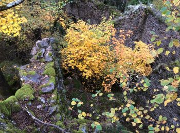
• Un tres beau parcours . Magnifique en automne

Randonnée Marche Estoher - Estoher - St Jeantres belle promenade pas  - Photo
Marche 7.967
Km

Marche

Moyen
Estoher, Occitanie, Pyrénées-Orientales, France
8 km | 15,7 km-effort
5h 0min
580 m
580 m
Oui
ThonyM

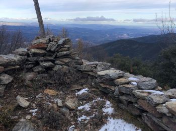
• Tres belle ballade du nouvel an qui en valait la peine

Randonnée Marche Estoher - Estoher Chapelle St. Étienne  - Photo
Marche 13.028
Km

Marche

Moyen
Estoher, Occitanie, Pyrénées-Orientales, France
13 km | 22 km-effort
3h 41min
707 m
703 m
Oui
oscar1

Randonnée Marche Estoher - 20211209 Estoher - Photo
Marche 10.197
Km

Marche

Difficile
Estoher, Occitanie, Pyrénées-Orientales, France
10,2 km | 22 km-effort
2h 58min
855 m
855 m
Oui
ThonyM

• Attention nous avons perdu la trace Super balade un peu sportive

Randonnée Marche Estoher - Mas Malet-La Mouline - Photo
Marche 10.74
Km

Marche

Moyen
Estoher, Occitanie, Pyrénées-Orientales, France
10,7 km | 17,2 km-effort
4h 10min
482 m
487 m
Oui
Machaon6

Randonnée A pied Estoher - Le Canigou etape 1 par GR 10 - Photo
A pied 8.004
Km

A pied

Difficile
Estoher, Occitanie, Pyrénées-Orientales, France
8 km | 15,9 km-effort
3h 10min
783 m
13 m
Non
Marc Auger

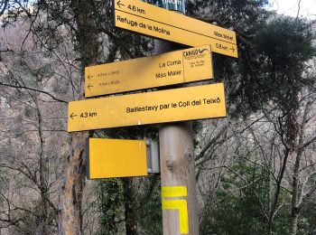
• Départ du parking d'Esquena d'Ase - Refuge des Cortalets.

Randonnée Marche Estoher - estoher 800m 10km - Photo
Marche 51.669
Km

Marche

Difficile
Estoher, Occitanie, Pyrénées-Orientales, France
52 km | 66 km-effort
4h 50min
1009 m
1339 m
Non
Erius

• attention glissades si humide

Randonnée Marche Estoher - Tour du roc de Jocavell - Photo
Marche 14.58
Km

Marche

Difficile
Estoher, Occitanie, Pyrénées-Orientales, France
14,6 km | 30 km-effort
5h 32min
1148 m
1154 m
Oui
Pek56

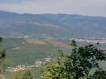
• Superbe randonnée ombragée sous de splendides hêtraies.

Randonnée Marche Estoher - Circuit Canigo day 6  - Photo
Marche 10.819
Km

Marche

Moyen
Estoher, Occitanie, Pyrénées-Orientales, France
10,8 km | 16,7 km-effort
2h 41min
73 m
1531 m
Non
Eric_Alu

• descente vers Vernet depuis refuge

Randonnée Marche Estoher - Prat Cabrera crete du Barbet et retour - Photo
Marche 9.675
Km

Marche

Très facile
Estoher, Occitanie, Pyrénées-Orientales, France
9,7 km | 24 km-effort
5h 55min
1104 m
1124 m
Non
micleo66

Randonnée Marche Estoher - Estoher - Photo
Marche 8.578
Km

Marche

Difficile
Estoher, Occitanie, Pyrénées-Orientales, France
8,6 km | 14,5 km-effort
3h 17min
444 m
448 m
Oui
ACEZAT

Randonnée Marche Estoher - maures - Photo
Marche 11.424
Km

Marche

Très difficile
Estoher, Occitanie, Pyrénées-Orientales, France
11,4 km | 22 km-effort
4h 29min
792 m
792 m
Oui
michcoq

Randonnée Marche Estoher - estoher - Photo
Marche 12.116
Km

Marche

Difficile
Estoher, Occitanie, Pyrénées-Orientales, France
12,1 km | 23 km-effort
7h 8min
809 m
808 m
Oui
michcoq

Randonnée Marche Estoher - estoher - Photo
Marche 13.72
Km

Marche

Très facile
Estoher, Occitanie, Pyrénées-Orientales, France
13,7 km | 25 km-effort
7h 55min
839 m
856 m
Oui
Jean-Jacques MARTI

Randonnée Marche Estoher - Estoher-Finestret-Estoher - Photo
Marche 10.036
Km

Marche

Moyen
Estoher, Occitanie, Pyrénées-Orientales, France
10 km | 16,4 km-effort
2h 48min
479 m
475 m
Oui
oscar1

Randonnée Autre activité Estoher - estoher chapelle st jean - Photo
Autre activité 3.641
Km

Autre activité

Très facile
Estoher, Occitanie, Pyrénées-Orientales, France
3,6 km | 4,5 km-effort
1h 25min
66 m
71 m
Oui
pat2103

17 randonnées affichées sur 17

Application GPS de randonnée GRATUITE

Logo SityTrail SityTrail

IGN / Instituts géographiques

Télécharger SityTrail sur l'App Store Télécharger SityTrail sur Google Play

Logo SityTrail SityTrail World

Le monde est à vous

Télécharger SityTrail sur l'App Store Télécharger SityTrail sur Google Play Télécharger SityTrail sur Huawei AppGallery

Activités

Fermer
Mes abonnements