L'Hospitalet-près-l'Andorre, Ariège : Les meilleures randonnées, itinéraires, parcours, balades et promenades

6 commentaires

L'Hospitalet-près-l'Andorre : découvrez les meilleures randonnées : 38 pédestres. Tous ces circuits, parcours, itinéraires et activités en plein air sont disponibles dans nos applications SityTrail pour smartphones et tablettes.


Les meilleurs parcours (38)

Randonnée Marche L'Hospitalet-près-l'Andorre - Tour du Nérassol - Photo
Marche 13.525
Km

Marche

Difficile
(2)
L'Hospitalet-près-l'Andorre, Occitanie, Ariège, France
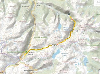
13,5 km | 27 km-effort
4h 0min
1012 m
1010 m
Oui
tracegps

• A partir de L'Hospitalet-près-l'Andorre, on démarre sur le chemin après le parking proche du pont Ste Suzanne. On sui...

Randonnée Marche L'Hospitalet-près-l'Andorre - étang  des Bésines - Photo
Marche 15.529
Km

Marche

Facile
(1)
L'Hospitalet-près-l'Andorre, Occitanie, Ariège, France
15,5 km | 25 km-effort
5h 14min
717 m
711 m
Oui
fhascoet

Randonnée Marche L'Hospitalet-près-l'Andorre - Etangs du Sisca - Photo
Marche 12.928
Km

Marche

Moyen
(1)
L'Hospitalet-près-l'Andorre, Occitanie, Ariège, France
12,9 km | 23 km-effort
4h 44min
766 m
768 m
Oui
petit-pied

Randonnée Marche L'Hospitalet-près-l'Andorre - Lac Brounic - Photo
Marche 3.814
Km

Marche

Moyen
L'Hospitalet-près-l'Andorre, Occitanie, Ariège, France
3,8 km | 9,2 km-effort
2h 59min
542 m
1 m
Non
AdrienB

• Monté par le GR68 pas facile au début. la fin est plus simple.

Randonnée Marche L'Hospitalet-près-l'Andorre - Traversée Bésines Enbeys Orlu D+1050m - Photo
Marche 22.71
Km

Marche

Très difficile
L'Hospitalet-près-l'Andorre, Occitanie, Ariège, France
23 km | 38 km-effort
8h 38min
1052 m
1446 m
Non
ericberlin

• Itinéraire très bien balisé En saison 2 refuges sur le parcours https://refugedesbesines.ffcam.fr/ https://www.refuge...

Randonnée Marche L'Hospitalet-près-l'Andorre - Etang de Besines - Photo
Marche 12.958
Km

Marche

Moyen
(2)
L'Hospitalet-près-l'Andorre, Occitanie, Ariège, France
13 km | 21 km-effort
5h 9min
578 m
580 m
Oui
kephas

Randonnée Marche L'Hospitalet-près-l'Andorre - Etang Moulsut par Les Bésines - Photo
Marche 15.151
Km

Marche

Moyen
L'Hospitalet-près-l'Andorre, Occitanie, Ariège, France
15,2 km | 26 km-effort
6h 30min
799 m
799 m
Oui
tracegps

• Montée de l'Hospitalet près d'Andorre

Randonnée Marche L'Hospitalet-près-l'Andorre - L'hospitalet-Pres-l'Andorre - Photo
Marche 3.895
Km

Marche

Moyen
L'Hospitalet-près-l'Andorre, Occitanie, Ariège, France
3,9 km | 5,8 km-effort
1h 41min
4 m
552 m
Non
AdrienB

• Descente du lac des Brougnic vers L'hospitalet-Pres-l'Andorre

Randonnée Marche L'Hospitalet-près-l'Andorre - Pic de la Cabaneta  - Photo
Marche 15.793
Km

Marche

Très difficile
L'Hospitalet-près-l'Andorre, Occitanie, Ariège, France
15,8 km | 34 km-effort
7h 49min
1396 m
1397 m
Oui
c.chehere

• Parking l'Hospitalet

Randonnée Marche L'Hospitalet-près-l'Andorre - l'Hospitalet refuge des Besines  - Photo
Marche 16.15
Km

Marche

Très difficile
L'Hospitalet-près-l'Andorre, Occitanie, Ariège, France
16,1 km | 26 km-effort
4h 50min
776 m
777 m
Oui
arnaudconde

Randonnée Marche L'Hospitalet-près-l'Andorre - J1 - Photo
Marche 11.601
Km

Marche

Très difficile
L'Hospitalet-près-l'Andorre, Occitanie, Ariège, France
11,6 km | 26 km-effort
5h 55min
1330 m
454 m
Non
dewasseigean

• Hospitalet- Jurca

Randonnée Marche L'Hospitalet-près-l'Andorre - Etangs Moulsut - Photo
Marche 16.127
Km

Marche

Très difficile
L'Hospitalet-près-l'Andorre, Occitanie, Ariège, France
16,1 km | 27 km-effort
6h 9min
824 m
824 m
Oui
domijeff

• départ de l'Hospitalet et passage par l'étang et le refuge des Besines

Randonnée Marche L'Hospitalet-près-l'Andorre - porteille des bésines, de l'Hospitalet à Mérens - Photo
Marche 16.702
Km

Marche

Difficile
L'Hospitalet-près-l'Andorre, Occitanie, Ariège, France
16,7 km | 31 km-effort
6h 11min
973 m
1350 m
Non
dporcher

• Magnifique rando. Le retour par la vallée du Nabre semble interminable...Si l'on a laissé sa voiture à l'Hospitalet o...

Randonnée A pied L'Hospitalet-près-l'Andorre - L Hospitalet vers Peric avec Barbara .. - Photo
A pied 59.014
Km

A pied

Très facile
L'Hospitalet-près-l'Andorre, Occitanie, Ariège, France
59 km | 97 km-effort
Inconnu
2851 m
2853 m
Oui
ign090820

• Le tour des Péric

Randonnée Marche L'Hospitalet-près-l'Andorre - Tour du pic de Nérassol - Photo
Marche 15.455
Km

Marche

Difficile
L'Hospitalet-près-l'Andorre, Occitanie, Ariège, France
15,5 km | 29 km-effort
7h 59min
1020 m
1020 m
Oui
Alokteff

• Boucle L'Hospitalet-près-l'Andorre - Etang de Sisca- Porteille de Sisca - Etang de Pedorrès - L'Hospitalet

Randonnée Marche L'Hospitalet-près-l'Andorre - Refuge besines j 1 étang et col anyiel - Photo
Marche 16.187
Km

Marche

L'Hospitalet-près-l'Andorre, Occitanie, Ariège, France
16,2 km | 0 m-effort
7h 32min
0 m
0 m
Non
pio31

Randonnée Marche L'Hospitalet-près-l'Andorre - Etang Moulsut par Les Bésines - Photo
Marche 15.151
Km

Marche

Moyen
L'Hospitalet-près-l'Andorre, Occitanie, Ariège, France
15,2 km | 26 km-effort
5h 15min
799 m
799 m
Oui
c.chehere

• Montée de l'Hospitalet près d'Andorre en passant par le refuge des Besines

Randonnée Marche L'Hospitalet-près-l'Andorre - Tour du Nérassol par étangs du Sisca et de Pédoures - Photo
Marche 15.643
Km

Marche

Moyen
L'Hospitalet-près-l'Andorre, Occitanie, Ariège, France
15,6 km | 29 km-effort
5h 49min
1024 m
1026 m
Oui
toutankhcarton

• Départ depuis L'Hospitalet Passage par Porteille du Sisca (2440m)

Randonnée Marche L'Hospitalet-près-l'Andorre - 09_L'Hospitalet - Photo
Marche 15.647
Km

Marche

Difficile
L'Hospitalet-près-l'Andorre, Occitanie, Ariège, France
15,6 km | 29 km-effort
7h 10min
1019 m
1020 m
Oui
jab31

• L'étang de Pédoures; montagne

Randonnée Marche L'Hospitalet-près-l'Andorre - Le Pic d'Auriol - L'Hospitalet près l'Andorre - Photo
Marche 19.788
Km

Marche

Très difficile
L'Hospitalet-près-l'Andorre, Occitanie, Ariège, France
19,8 km | 38 km-effort
8h 0min
1394 m
1395 m
Oui
tracegps

• De la Jasse du Pla, un peu avant le refuge des Bésines la montée n'est pas balisée, il faut trouver son chemin parmi ...

20 randonnées affichées sur 38

Application GPS de randonnée GRATUITE

Logo SityTrail SityTrail

IGN / Instituts géographiques

Télécharger SityTrail sur l'App Store Télécharger SityTrail sur Google Play

Logo SityTrail SityTrail World

Le monde est à vous

Télécharger SityTrail sur l'App Store Télécharger SityTrail sur Google Play Télécharger SityTrail sur Huawei AppGallery

Activités

Fermer
Mes abonnements