Candes-Saint-Martin, Indre-et-Loire : Les meilleures randonnées, itinéraires, parcours, balades et promenades

Candes-Saint-Martin : découvrez les meilleures randonnées : 8 pédestres et 4 à vélo ou VTT. Tous ces circuits, parcours, itinéraires et activités en plein air sont disponibles dans nos applications SityTrail pour smartphones et tablettes.


Les meilleurs parcours (12)

Randonnée Marche Candes-Saint-Martin - Candes-Saint-Martin - Montsoreau GR3 - 9.6km 140m 2h25 (40mn) - 2023 10 01 - Photo
Marche 9.588
Km

Marche

Moyen
Candes-Saint-Martin, Centre-Val de Loire, Indre-et-Loire, France
9,6 km | 11,5 km-effort
2h 25min
147 m
141 m
Oui
Orcal37

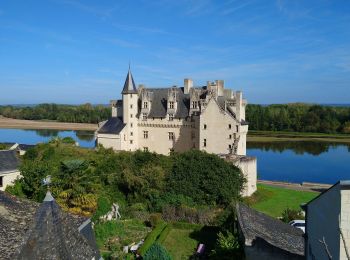
• Candes-Saint-Martin - Montsoreau - GR3 - 9.6km 140m 2h25 (40mn) - 2023 10 01

Randonnée Marche Candes-Saint-Martin - cande saumur - Photo
Marche 19.43
Km

Marche

Moyen
Candes-Saint-Martin, Centre-Val de Loire, Indre-et-Loire, France
19,4 km | 24 km-effort
6h 29min
317 m
317 m
Non
louis49

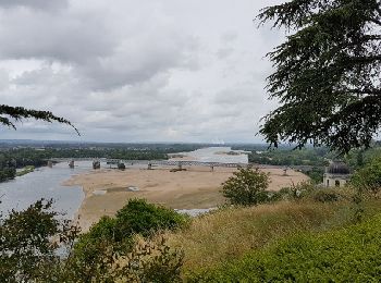
• le long de la loire.

Randonnée Vélo Candes-Saint-Martin - LA VOIE ROMAINE - Photo
Vélo 12.833
Km

Vélo

Facile
Candes-Saint-Martin, Centre-Val de Loire, Indre-et-Loire, France
12,8 km | 14,1 km-effort
49min
94 m
95 m
Oui
laoj

• PETITE BALLADE EN FAMILLE AU NORD DE LA VIENNE AUCUNE DIFFICULTE CIRCUIT PLAT !

Randonnée Vélo Candes-Saint-Martin - Loire à Vélo n° 4 - Photo
Vélo 26.944
Km

Vélo

Facile
Candes-Saint-Martin, Centre-Val de Loire, Indre-et-Loire, France
27 km | 29 km-effort
1h 43min
183 m
186 m
Non
mimi53

• Loire à vélo de Candes St Martin à Bréhémont

Randonnée Course à pied Candes-Saint-Martin -  Candes-Saumur - Photo
Course à pied 13.812
Km

Course à pied

Très facile
Candes-Saint-Martin, Centre-Val de Loire, Indre-et-Loire, France
13,8 km | 17,7 km-effort
Inconnu
294 m
284 m
Non
escopac

Randonnée Course à pied Candes-Saint-Martin -  Candes-Saumur - Photo
Course à pied 13.812
Km

Course à pied

Très facile
Candes-Saint-Martin, Centre-Val de Loire, Indre-et-Loire, France
13,8 km | 17,7 km-effort
Inconnu
294 m
284 m
Non
escopac

Randonnée Marche Candes-Saint-Martin - Candé saint Martin Fontevraud - Photo
Marche 18.451
Km

Marche

Moyen
Candes-Saint-Martin, Centre-Val de Loire, Indre-et-Loire, France
18,5 km | 22 km-effort
3h 54min
284 m
282 m
Oui
taguette

Randonnée Marche Candes-Saint-Martin - ça dès st martin - Photo
Marche 18.165
Km

Marche

Très facile
Candes-Saint-Martin, Centre-Val de Loire, Indre-et-Loire, France
18,2 km | 22 km-effort
6h 57min
317 m
289 m
Non
lecorvec

Randonnée Vélo Candes-Saint-Martin - 05-Rigny-Usse_Candes-St-Martin_ - Photo
Vélo 24.643
Km

Vélo

Très facile
Candes-Saint-Martin, Centre-Val de Loire, Indre-et-Loire, France
25 km | 27 km-effort
1h 33min
167 m
161 m
Non
murph

Randonnée Vélo Candes-Saint-Martin - 04_CandesStMartin_Saumur 18.2 - Photo
Vélo 18.157
Km

Vélo

Très facile
Candes-Saint-Martin, Centre-Val de Loire, Indre-et-Loire, France
18,2 km | 21 km-effort
1h 14min
207 m
201 m
Non
murph

Randonnée Marche Candes-Saint-Martin - 04_CandesStMartin_Saumur_A_parcours.gpx - Photo
Marche 18.158
Km

Marche

Très facile
Candes-Saint-Martin, Centre-Val de Loire, Indre-et-Loire, France
18,2 km | 21 km-effort
Inconnu
207 m
200 m
Non
murph

Randonnée Marche Candes-Saint-Martin - Pic Epeiche 4 - Candes-Saint-Martin - Photo
Marche 2.503
Km

Marche

Facile
Candes-Saint-Martin, Centre-Val de Loire, Indre-et-Loire, France
2,5 km | 3,2 km-effort
49min
55 m
55 m
Oui
pmg.griot

12 randonnées affichées sur 12

Application GPS de randonnée GRATUITE

Logo SityTrail SityTrail

IGN / Instituts géographiques

Télécharger SityTrail sur l'App Store Télécharger SityTrail sur Google Play

Logo SityTrail SityTrail World

Le monde est à vous

Télécharger SityTrail sur l'App Store Télécharger SityTrail sur Google Play Télécharger SityTrail sur Huawei AppGallery

Activités

Fermer
Mes abonnements