Accueil
World
NEW
Premium
Shop
Randonnées
Articles
Aide - support
Français
English
Nederlands
Español
Italiano
Deutsch
Connexion
Accueil
World
Premium
Shop
Randonnées
Articles
Aide - support
SityTrail
>
Points d'intérêt
>
GCVR32
SityTrail
>
Points d'intérêt
>
GCVR32
GCVR32
Description
LA FORÊT DE BLAIRE WITCH by jo
Photos
GCVR32 est à découvir dans les randonnées suivantes...
tracegps
Dent du Villard depuis La Rosière
Marche
Difficile
(1)
Courchevel, Auvergne-Rhône-Alpes, Savoie, France
9,4 km | 19,2 km-effort
6h 0min
Oui
tracegps
Utilisateur
©
OpenStreetMap
contributors
Localisation
Pays :
France
Région :
Auvergne-Rhône-Alpes
Département/Province :
Savoie
Commune :
Entrelacs
Localité :
Saint-Germain-la-Chambotte
Localisation
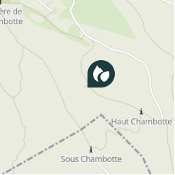
45.76855 / 5.880267
Date de création :
2018-04-09 12:21:51.555
Dernière modification
2018-04-09 12:21:51.555
(0 Avis)
Commentaires
Veuillez vous connecter pour laisser un commentaire ou une note
Points d'intérêt à proximité
tracegps
GCVR32
ENTRELACS
tracegps
GCVR32
ENTRELACS
tracegps
GCVR32
ENTRELACS
tracegps
GCVR32
ENTRELACS
tracegps
GCVR32
ENTRELACS
tracegps
GCVR32
ENTRELACS
tracegps
GCVR32
ENTRELACS
tracegps
GCVR32
ENTRELACS
Fermer
Mes abonnements