Randonnée V.T.T. Soultzbach-les-Bains - Rando du Petit Ballon - Photo
 tracegps
tracegps

Utilisateur

© OpenStreetMap contributors
Longueur
Longueur
30 km
Altitude max
Altitude max
1103 m
Dénivelé positif
Dénivelé positif
1113 m
Km-Effort
Km-Effort  
45 km
Altitude min
Altitude min
329 m
Dénivelé négatif
Dénivelé négatif
1116 m
Boucle
Boucle
Oui
Date de création :
2014-12-10 00:00:00.0
Dernière modification :
2014-12-10 00:00:00.0

(0 Avis)

V.T.T.
V.T.T.
3h00
Difficulté : Très difficile

Scannez ce code QR pour ouvrir la randonnée dans l'application SityTrail

Application GPS de randonnée GRATUITE

Logo SityTrail SityTrail

IGN / Instituts géographiques

Télécharger SityTrail sur l'App Store Télécharger SityTrail sur Google Play

Logo SityTrail SityTrail World

Le monde est à vous

Télécharger SityTrail sur l'App Store Télécharger SityTrail sur Google Play Télécharger SityTrail sur Huawei AppGallery

À propos

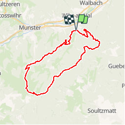
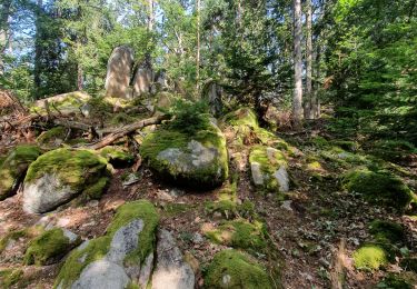
Randonnée V.T.T. de 30 km à découvrir à Grand Est, Haut-Rhin, Soultzbach-les-Bains. Cette randonnée est proposée par tracegps.

Description

Le descriptif est un mixage entre l'édition de 1994 et celle de 1999. Si vous partez de l'étang, vous aurez à affronter un petit raidillon avant de redescendre sur Soultzbach. De là une montée régulière sans difficultés ( si ce n'est la longueur ) vous amènera vers le col de Marbach.... La suite et une carte détaillée sont ICI Source: Cyclo-Club de la Vallée de Munster

Profil altimétrique

Photos

Localisation

Pays :
France
Région :
Grand Est
Département/Province :
Haut-Rhin
Commune :
Soultzbach-les-Bains
Localité :
Unknown
Départ:(Dec)
Départ:(UTM)
366078 ; 5322058 (32U) N.

Randonnées à proximité

Randonnée Marche Munster - 19.06.13.Munster  - Photo
Marche
ROPPJP

Marche

Très facile
(1)
Munster, Grand Est, Haut-Rhin, France
7,3 km | 10,6 km-effort
2h 10min
Oui
Randonnée Randonnée équestre Gunsbach - Le petit Hohnack - verkort (23) - Photo
Randonnée équestre
eddyvermeulen1

Randonnée équestre

Facile
(1)
Gunsbach, Grand Est, Haut-Rhin, France
13,1 km | 18,4 km-effort
2h 25min
Oui
Randonnée Marche Wintzenheim - Château de Pflixbourg depuis Saint Gilles - Photo
Marche
sit68000

Marche

Facile
(1)
Wintzenheim, Grand Est, Haut-Rhin, France
3,7 km | 6,2 km-effort
1h 21min
Oui
Randonnée Marche Wasserbourg - Autour de Wasserbourg - Photo
Marche
bob68

Marche

Facile
(1)
Wasserbourg, Grand Est, Haut-Rhin, France
8,8 km | 14 km-effort
2h 6min
Oui
Randonnée Marche Munster - Munster Narrenstein - Photo
Marche
serge.rougerie

Marche

Moyen
(1)
Munster, Grand Est, Haut-Rhin, France
4,7 km | 7,7 km-effort
1h 24min
Non
Randonnée A pied Walbach - wihr au val - le petit hohnack - Photo
A pied
OxygenLT

A pied

Moyen
(1)
Walbach, Grand Est, Haut-Rhin, France
15,6 km | 25 km-effort
5h 46min
Oui
Randonnée Marche Gunsbach - Gunsbach - Munster - Photo
Marche
Bart2015

Marche

Difficile
Gunsbach, Grand Est, Haut-Rhin, France
11,8 km | 18,3 km-effort
4h 9min
Oui
Randonnée Marche Wintzenheim - Boucle de la fontaine de la dame  - Photo
Marche
dudu42

Marche

Moyen
Wintzenheim, Grand Est, Haut-Rhin, France
7,9 km | 12,6 km-effort
2h 0min
Oui
Randonnée Marche Wintzenheim - rdpr witzenheim 210907 - Photo
Marche
GUIDE
stempfel52

Marche

Très difficile
Wintzenheim, Grand Est, Haut-Rhin, France
16,2 km | 24 km-effort
5h 52min
Oui


Fermer
Mes abonnements