Randonnée Vélo Saubion - saubion - seignosse - tosse - saubion - Photo

saubion - seignosse - tosse - saubion

 lolomilastef
lolomilastef

Utilisateur

© OpenStreetMap contributors
Longueur
Longueur
17,3 km
Altitude max
Altitude max
40 m
Dénivelé positif
Dénivelé positif
172 m
Km-Effort
Km-Effort  
19,6 km
Altitude min
Altitude min
12 m
Dénivelé négatif
Dénivelé négatif
173 m
Boucle
Boucle
Oui
Date de création :
2019-01-15 14:08:15.303
Dernière modification :
2019-01-15 14:08:15.303

(1 Avis)

Vélo
Vélo
1h09
Difficulté : Facile

Scannez ce code QR pour ouvrir la randonnée dans l'application SityTrail

Application GPS de randonnée GRATUITE

Logo SityTrail SityTrail

IGN / Instituts géographiques

Télécharger SityTrail sur l'App Store Télécharger SityTrail sur Google Play

Logo SityTrail SityTrail World

Le monde est à vous

Télécharger SityTrail sur l'App Store Télécharger SityTrail sur Google Play Télécharger SityTrail sur Huawei AppGallery

À propos

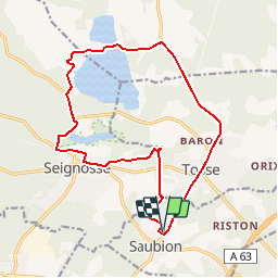
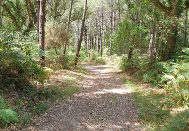
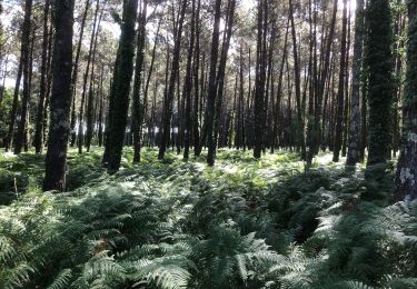
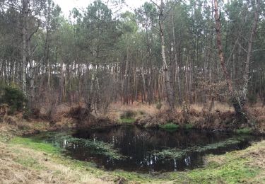
Randonnée Vélo de 17,3 km à découvrir à Nouvelle-Aquitaine, Landes, Saubion. Cette randonnée est proposée par lolomilastef.

Profil altimétrique

Localisation

Pays :
France
Région :
Nouvelle-Aquitaine
Département/Province :
Landes
Commune :
Saubion
Localité :
Unknown
Départ:(Dec)
Départ:(UTM)
633357 ; 4837018 (30T) N.

Commentaires

Veuillez vous connecter pour laisser un commentaire ou une note


Randonnées à proximité

Randonnée Vélo Bénesse-Maremne - Boucles des lacs - Benesse - Photo
Vélo
tracegps

Vélo

Facile
(1)
Bénesse-Maremne, Nouvelle-Aquitaine, Landes, France
75 km | 85 km-effort
3h 0min
Oui
Randonnée Marche Seignosse - seignosse  - Photo
Marche
Titome

Marche

Moyen
Seignosse, Nouvelle-Aquitaine, Landes, France
10,1 km | 12,5 km-effort
3h 0min
Non
Randonnée V.T.T. Soorts-Hossegor - Boucle Seignosse - Souston - Photo
V.T.T.
phibos

V.T.T.

Facile
Soorts-Hossegor, Nouvelle-Aquitaine, Landes, France
35 km | 40 km-effort
3h 20min
Oui
Randonnée V.T.T. Soorts-Hossegor - Soorts_Plage du Penon - Photo
V.T.T.
ChristopheLefauconnier

V.T.T.

Moyen
(1)
Soorts-Hossegor, Nouvelle-Aquitaine, Landes, France
23 km | 27 km-effort
1h 52min
Oui
Randonnée Marche Seignosse - 40 SEIGNOSSE-BOURG, réservé naturelle de l'Etang Noir, l'étang blanc et l'étang D'Hardy, forêts de Soustons et SEIGNOSSE  - Photo
Marche
jeff66

Marche

Moyen
Seignosse, Nouvelle-Aquitaine, Landes, France
11,5 km | 14 km-effort
2h 8min
Oui
Randonnée Marche Seignosse - Étang noir - Photo
Marche
yoye

Marche

Très facile
Seignosse, Nouvelle-Aquitaine, Landes, France
1,5 km | 1,6 km-effort
21min
Oui
Randonnée V.T.T. Bénesse-Maremne - Tour benesse - Photo
V.T.T.
alain.moisset@orange.fr

V.T.T.

Facile
Bénesse-Maremne, Nouvelle-Aquitaine, Landes, France
26 km | 29 km-effort
2h 23min
Oui
Randonnée Course à pied Saint-Vincent-de-Tyrosse - Trail de Semisens 2013 - Saint Vincent de Tyrosse - Photo
Course à pied
tracegps

Course à pied

Moyen
Saint-Vincent-de-Tyrosse, Nouvelle-Aquitaine, Landes, France
25 km | 29 km-effort
2h 30min
Oui
Randonnée Marche Seignosse - Lac blanc seignosse - Photo
Marche
yoye

Marche

Très facile
Seignosse, Nouvelle-Aquitaine, Landes, France
10,6 km | 12,8 km-effort
2h 36min
Non


Fermer
Mes abonnements