Randonnée Cheval Lalbenque - Marcenac-Couanac - Photo

Marcenac-Couanac

 gabriela.pfeifle
gabriela.pfeifle

Utilisateur

© OpenStreetMap contributors
Longueur
Longueur
13,7 km
Altitude max
Altitude max
316 m
Dénivelé positif
Dénivelé positif
153 m
Km-Effort
Km-Effort  
15,7 km
Altitude min
Altitude min
262 m
Dénivelé négatif
Dénivelé négatif
159 m
Boucle
Boucle
Non
Date de création :
2019-02-26 10:29:49.99
Dernière modification :
2019-02-26 10:29:49.99

(0 Avis)

Cheval
Cheval
2h00
Difficulté : Moyen

Scannez ce code QR pour ouvrir la randonnée dans l'application SityTrail

Application GPS de randonnée GRATUITE

Logo SityTrail SityTrail

IGN / Instituts géographiques

Télécharger SityTrail sur l'App Store Télécharger SityTrail sur Google Play

Logo SityTrail SityTrail World

Le monde est à vous

Télécharger SityTrail sur l'App Store Télécharger SityTrail sur Google Play Télécharger SityTrail sur Huawei AppGallery

À propos

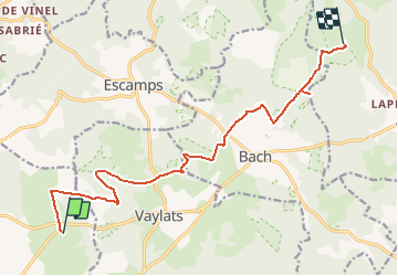
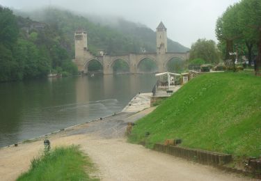
Randonnée Cheval de 13,7 km à découvrir à Occitanie, Lot, Lalbenque. Cette randonnée est proposée par gabriela.pfeifle.

Profil altimétrique

Points d'intérêt

Point d'intérêt Varaire - Panorama - Photo
gabriela.pfeifle
VARAIRE 

Localisation

Pays :
France
Région :
Occitanie
Département/Province :
Lot
Commune :
Lalbenque
Localité :
Unknown
Départ:(Dec)
Départ:(UTM)
389365 ; 4909831 (31T) N.

Randonnées à proximité

Randonnée Vélo Lalbenque - Circuit cyclotourisme Lalbenque / St Cirq Lapopie - Photo
Vélo
tracegps

Vélo

Difficile
(1)
Lalbenque, Occitanie, Lot, France
61 km | 75 km-effort
6h 0min
Oui
Randonnée Marche Escamps - de Varaire à Lalbenque Lot  - Photo
Marche
Maria Chapalain

Marche

Moyen
Escamps, Occitanie, Lot, France
7,2 km | 8,3 km-effort
4h 44min
Non
Randonnée Marche Escamps - Escamp 3 - Photo
Marche
GUIDE
antignacs

Marche

Moyen
Escamps, Occitanie, Lot, France
13,7 km | 16,2 km-effort
2h 58min
Oui
Randonnée Marche Bach - CC_Velay_DB_14_Bach_Cahors_20080505 - Photo
Marche
patrickdanilo

Marche

Facile
Bach, Occitanie, Lot, France
26 km | 32 km-effort
6h 5min
Non
Randonnée Marche Lalbenque - Balade coup de coeur du gîte de Poudally - Photo
Marche
tracegps

Marche

Moyen
Lalbenque, Occitanie, Lot, France
16,4 km | 19,9 km-effort
4h 30min
Oui
Randonnée Marche Concots - Escamps  - Photo
Marche
GUIDE
antignacs

Marche

Très facile
Concots, Occitanie, Lot, France
10,9 km | 12,5 km-effort
2h 14min
Oui
Randonnée Marche Bach - Bach varayre  - Photo
Marche
GUIDE
antignacs

Marche

Très facile
Bach, Occitanie, Lot, France
12,4 km | 14,7 km-effort
2h 25min
Oui
Randonnée Marche Lalbenque - Balade découverte du petit patrimoine - Lalbenque - Photo
Marche
tracegps

Marche

Moyen
Lalbenque, Occitanie, Lot, France
13,1 km | 16,1 km-effort
3h 15min
Oui
Randonnée Marche Lalbenque - Circuit des châteaux - Lalbenque - Photo
Marche
tracegps

Marche

Moyen
Lalbenque, Occitanie, Lot, France
19,6 km | 23 km-effort
5h 30min
Oui


Fermer
Mes abonnements