Randonnée V.T.T. Val d'Arry - Le Locheur - Photo
 tracegps
tracegps

Utilisateur

© OpenStreetMap contributors
Longueur
Longueur
40 km
Altitude max
Altitude max
165 m
Dénivelé positif
Dénivelé positif
740 m
Km-Effort
Km-Effort  
50 km
Altitude min
Altitude min
22 m
Dénivelé négatif
Dénivelé négatif
747 m
Boucle
Boucle
Oui
Date de création :
2014-12-10 00:00:00.0
Dernière modification :
2014-12-10 00:00:00.0

(0 Avis)

V.T.T.
V.T.T.
2h30
Difficulté : Difficile

Scannez ce code QR pour ouvrir la randonnée dans l'application SityTrail

Application GPS de randonnée GRATUITE

Logo SityTrail SityTrail

IGN / Instituts géographiques

Télécharger SityTrail sur l'App Store Télécharger SityTrail sur Google Play

Logo SityTrail SityTrail World

Le monde est à vous

Télécharger SityTrail sur l'App Store Télécharger SityTrail sur Google Play Télécharger SityTrail sur Huawei AppGallery

À propos

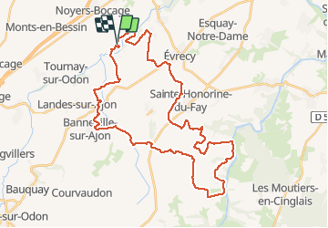
Randonnée V.T.T. de 40 km à découvrir à Normandie, Calvados, Val d'Arry. Cette randonnée est proposée par tracegps.

Description

Boucle au départ de le Locheur, sur les côteaux de l'Odon.

Profil altimétrique

Localisation

Pays :
France
Région :
Normandie
Département/Province :
Calvados
Commune :
Val d'Arry
Localité :
Le Locheur
Départ:(Dec)
Départ:(UTM)
678926 ; 5442049 (30U) N.

Randonnées à proximité

Randonnée Marche Gavrus - gavrus08 - Photo
Marche
gr1346

Marche

Moyen
Gavrus, Normandie, Calvados, France
8,5 km | 9,7 km-effort
2h 6min
Oui
Randonnée Marche Parfouru-sur-Odon - Parfouru - Photo
Marche
gr1346

Marche

Moyen
(1)
Parfouru-sur-Odon, Normandie, Calvados, France
9,8 km | 12,1 km-effort
2h 36min
Oui
Randonnée A pied Val d'Arry - Autour de Le Locheur - Photo
A pied
PRO

A pied

Facile
Val d'Arry, Normandie, Calvados, France
7,9 km | 9,6 km-effort
2h 10min
Oui
Randonnée A pied Landes-sur-Ajon - De l'Ajon à l'Odon - Photo
A pied
PRO

A pied

Facile
Landes-sur-Ajon, Normandie, Calvados, France
13,2 km | 16,7 km-effort
3h 47min
Non
Randonnée Marche Sainte-Honorine-du-Fay - st hono dufay  - Photo
Marche
yannick14

Marche

Difficile
Sainte-Honorine-du-Fay, Normandie, Calvados, France
10,6 km | 13,5 km-effort
3h 4min
Oui
Randonnée V.T.T. Évrecy - 1er vttae 14062023 - Photo
V.T.T.
cedric14

V.T.T.

Moyen
Évrecy, Normandie, Calvados, France
24 km | 28 km-effort
1h 38min
Oui
Randonnée V.T.C. Bougy - VELO CAEN 2 - Photo
V.T.C.
UDGI54

V.T.C.

Très difficile
Bougy, Normandie, Calvados, France
40 km | 45 km-effort
3h 7min
Oui
Randonnée Marche Gavrus - Gavrus - Photo
Marche
papylou7

Marche

Difficile
Gavrus, Normandie, Calvados, France
14 km | 16,8 km-effort
3h 48min
Oui
Randonnée V.T.T. Parfouru-sur-Odon - VTT Vallée de l'Odon #2 26 km - Photo
V.T.T.
BureauChris

V.T.T.

Moyen
Parfouru-sur-Odon, Normandie, Calvados, France
26 km | 32 km-effort
2h 8min
Oui


Fermer
Mes abonnements