Randonnée Course à pied Sousceyrac-en-Quercy - circuit 11 amelioré - Photo
 kayakiste15
kayakiste15

Utilisateur

© OpenStreetMap contributors
Longueur
Longueur
14,2 km
Altitude max
Altitude max
696 m
Dénivelé positif
Dénivelé positif
329 m
Km-Effort
Km-Effort  
18,6 km
Altitude min
Altitude min
552 m
Dénivelé négatif
Dénivelé négatif
332 m
Boucle
Boucle
Oui
Date de création :
2019-01-15 17:02:20.395
Dernière modification :
2019-01-15 17:02:20.395

(0 Avis)

Course à pied
Course à pied
1h25
Difficulté : Moyen

Scannez ce code QR pour ouvrir la randonnée dans l'application SityTrail

Application GPS de randonnée GRATUITE

Logo SityTrail SityTrail

IGN / Instituts géographiques

Télécharger SityTrail sur l'App Store Télécharger SityTrail sur Google Play

Logo SityTrail SityTrail World

Le monde est à vous

Télécharger SityTrail sur l'App Store Télécharger SityTrail sur Google Play Télécharger SityTrail sur Huawei AppGallery

À propos

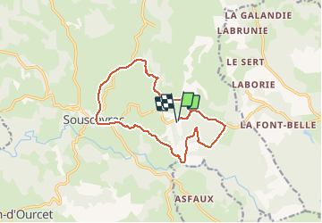
Randonnée Course à pied de 14,2 km à découvrir à Occitanie, Lot, Sousceyrac-en-Quercy. Cette randonnée est proposée par kayakiste15.

Description

du ruisseau aux collines en passant par lac de pêche

Profil altimétrique

Localisation

Pays :
France
Région :
Occitanie
Département/Province :
Lot
Commune :
Sousceyrac-en-Quercy
Localité :
Sousceyrac
Départ:(Dec)
Départ:(UTM)
426388 ; 4969303 (31T) N.

Randonnées à proximité

Randonnée V.T.T. Sousceyrac-en-Quercy - les fougères 2024 - Photo
V.T.T.
kayakiste15

V.T.T.

Moyen
Sousceyrac-en-Quercy, Occitanie, Lot, France
37 km | 48 km-effort
2h 36min
Non
Randonnée V.T.T. Sousceyrac-en-Quercy - Sousceyrac - Lac de Tolerme  - Photo
V.T.T.
Gpoujade

V.T.T.

Très difficile
Sousceyrac-en-Quercy, Occitanie, Lot, France
32 km | 41 km-effort
2h 50min
Oui
Randonnée Autre activité Sousceyrac-en-Quercy - vtt lot Sousceyrac  - Photo
Autre activité
momodoudou

Autre activité

Très facile
Sousceyrac-en-Quercy, Occitanie, Lot, France
31 km | 40 km-effort
3h 10min
Oui
Randonnée Moteur Sousceyrac-en-Quercy - ballade 4X4 haut segala - Photo
Moteur
alain46

Moteur

Facile
Sousceyrac-en-Quercy, Occitanie, Lot, France
96 km | 123 km-effort
7h 30min
Oui
Randonnée Marche Sousceyrac-en-Quercy - les lotois - Photo
Marche
vialette

Marche

Très difficile
Sousceyrac-en-Quercy, Occitanie, Lot, France
22 km | 29 km-effort
6h 12min
Oui
Randonnée Marche Sousceyrac-en-Quercy - Le Cayla - Photo
Marche
GLORIEUX_PH

Marche

Moyen
Sousceyrac-en-Quercy, Occitanie, Lot, France
11,2 km | 14,4 km-effort
2h 42min
Oui
Randonnée Marche Sousceyrac-en-Quercy - Les Cambous - Photo
Marche
GLORIEUX_PH

Marche

Moyen
Sousceyrac-en-Quercy, Occitanie, Lot, France
6,7 km | 8,7 km-effort
2h 0min
Oui
Randonnée Marche Sousceyrac-en-Quercy - De Sousceyrac au Lac du Tolerme - Photo
Marche
GLORIEUX_PH

Marche

Facile
Sousceyrac-en-Quercy, Occitanie, Lot, France
8,4 km | 10,8 km-effort
1h 52min
Non
Randonnée Marche Labastide-du-Haut-Mont - labastide du haut mont - Photo
Marche
daniel46100

Marche

Moyen
Labastide-du-Haut-Mont, Occitanie, Lot, France
13,1 km | 18,8 km-effort
3h 56min
Oui


Fermer
Mes abonnements