Randonnée Marche Saint-Hubert - Mirwart - Parc (SH27) - Photo
 grande_foret_sthubert
grande_foret_sthubert

Utilisateur GUIDE

© OpenStreetMap contributors
Longueur
Longueur
4,2 km
Altitude max
Altitude max
328 m
Dénivelé positif
Dénivelé positif
103 m
Km-Effort
Km-Effort  
5,6 km
Altitude min
Altitude min
258 m
Dénivelé négatif
Dénivelé négatif
104 m
Boucle
Boucle
Oui
Date de création :
2019-01-15 17:53:35.082
Dernière modification :
2019-01-15 17:53:35.082

(0 Avis)

Marche
Marche
1h13
Difficulté : Facile

Scannez ce code QR pour ouvrir la randonnée dans l'application SityTrail

Application GPS de randonnée GRATUITE

Logo SityTrail SityTrail

IGN / Instituts géographiques

Télécharger SityTrail sur l'App Store Télécharger SityTrail sur Google Play

Logo SityTrail SityTrail World

Le monde est à vous

Télécharger SityTrail sur l'App Store Télécharger SityTrail sur Google Play Télécharger SityTrail sur Huawei AppGallery

À propos

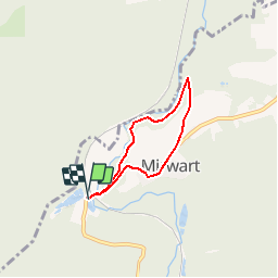
Randonnée Marche de 4,2 km à découvrir à Wallonie, Luxembourg, Saint-Hubert. Cette randonnée est proposée par grande_foret_sthubert.

Description

C'est une des quatre promenades du Domaine provincial de Mirwart.
Quittant la pisciculture en direction de Mirwart, vous trouverez juste avant la côte, sur votre gauche, le départ de cette promenade. Elle longe la Lomme à quelque hauteur, complétant la promenade du Marsoult. Les eaux, là encore, donnent leur rythme à la vie :la vie présente de la nature, mais aussi celle, passée, de l'industrie mirwartine.
Tout le long du parcours, vous pourrez également découvrir 24 espèces d'arbres identifiés tout au long de la promenade. Un livret explicatif "Le Monde des arbres" est en vente à la pisciculture de Mirwart, située à côté du point de départ de la promenade.

Extrait de la carte de promenade « Au Pays de Saint-Hubert » (30 balades pédestres, 6 circuits VTT – carte topographique 1/25.000) disponible au Royal Syndicat d’Initiative de Saint-Hubert au prix de 8€.

Royal Syndicat d’Initiative de Saint-Hubert
Place du Marché, n°15
B-6870 SAINT-HUBERT
Tél.:  32 (0)61 61 30 10
Fax:  32 (0)61 61 54 44
rsi@saint-hubert-tourisme.be
www.rsi-sainthubert.be
facebook.com/rsisainthubert

Profil altimétrique

Photos

Points d'intérêt

Point d'intérêt Saint-Hubert - Forge d’affinage - Photo
grande_foret_sthubert
SAINT-HUBERT 
Point d'intérêt Saint-Hubert - Réserve naturelle du Pré des Forge - Photo
grande_foret_sthubert
Point d'intérêt Saint-Hubert - Chemin des sangliers - Photo
grande_foret_sthubert
SAINT-HUBERT 
Point d'intérêt Saint-Hubert - Banc public - Photo
grande_foret_sthubert
SAINT-HUBERT 
Point d'intérêt Saint-Hubert - « Gouffre de la sorcière » - Photo
grande_foret_sthubert
Point d'intérêt Saint-Hubert - Reboisement - Photo
grande_foret_sthubert
SAINT-HUBERT 
Point d'intérêt Saint-Hubert - Le Parc - Photo
grande_foret_sthubert
SAINT-HUBERT 
Point d'intérêt Saint-Hubert - Départ - Photo
grande_foret_sthubert
SAINT-HUBERT 

Localisation

Pays :
Belgique
Région :
Wallonie
Département/Province :
Luxembourg
Commune :
Saint-Hubert
Localité :
Mirwart
Départ:(Dec)
Départ:(UTM)
661212 ; 5547030 (31U) N.

Randonnées à proximité

Randonnée Marche Tellin - Tellin. Natura 2000, des sites qui valent le détour ! Lx 7 - Photo
Marche
GUIDE+

Marche

Moyen
(6)
Tellin, Wallonie, Luxembourg, Belgique
9,6 km | 11,9 km-effort
1h 30min
Oui
Randonnée Marche Saint-Hubert - Poix - Sainte-Adeline (SH15) - Photo
Marche
GUIDE+

Marche

Moyen
(7)
Saint-Hubert, Wallonie, Luxembourg, Belgique
8,3 km | 10,8 km-effort
2h 23min
Oui
Randonnée Marche Saint-Hubert - Mirwart_Vieux Moulin de Mirwart_Alternative Forêt (SH29 bis) - Photo
Marche
GUIDE+

Marche

Difficile
(11)
Saint-Hubert, Wallonie, Luxembourg, Belgique
10,8 km | 14,2 km-effort
3h 4min
Oui
Randonnée Marche Tellin - RL-GG-13_Grupont_Poix-Saint-Hubert - Photo
Marche
PRO

Marche

Très difficile
(2)
Tellin, Wallonie, Luxembourg, Belgique
26 km | 34 km-effort
7h 23min
Non
Randonnée Marche Tellin - Balade à Grupont - Photo
Marche
GUIDE
Desrumaux

Marche

Facile
(1)
Tellin, Wallonie, Luxembourg, Belgique
8,4 km | 11,9 km-effort
2h 33min
Oui
Randonnée Marche Tellin - Bure - Promenade des chapelles - Photo
Marche
GUIDE+

Marche

Facile
(1)
Tellin, Wallonie, Luxembourg, Belgique
4,5 km | 5,9 km-effort
1h 15min
Oui
Randonnée Marche Tellin - Tellin - Promenade du trou des Lûtons - Photo
Marche
GUIDE+

Marche

Facile
(1)
Tellin, Wallonie, Luxembourg, Belgique
5,2 km | 6,1 km-effort
1h 21min
Oui
Randonnée A pied Tellin - Tellin - Promenade des étangs - Photo
A pied
GUIDE+

A pied

Moyen
(2)
Tellin, Wallonie, Luxembourg, Belgique
20 km | 27 km-effort
Inconnu
Oui
Randonnée Marche Tellin - Grupont - Promenade du bois de Machi - Photo
Marche
GUIDE+

Marche

Moyen
(1)
Tellin, Wallonie, Luxembourg, Belgique
8,6 km | 12,6 km-effort
2h 37min
Oui


Fermer
Mes abonnements