Randonnée V.T.T. Morée - Circuit de vallées et coteaux n° 3 - Morée - Photo

Circuit de vallées et coteaux n° 3 - Morée

 tracegps
tracegps

Utilisateur

© OpenStreetMap contributors
Longueur
Longueur
16,5 km
Altitude max
Altitude max
150 m
Dénivelé positif
Dénivelé positif
178 m
Km-Effort
Km-Effort  
18,9 km
Altitude min
Altitude min
85 m
Dénivelé négatif
Dénivelé négatif
179 m
Boucle
Boucle
Oui
Date de création :
2014-12-10 00:00:00.0
Dernière modification :
2014-12-10 00:00:00.0

(0 Avis)

V.T.T.
V.T.T.
2h00
Difficulté : Moyen

Scannez ce code QR pour ouvrir la randonnée dans l'application SityTrail

Application GPS de randonnée GRATUITE

Logo SityTrail SityTrail

IGN / Instituts géographiques

Télécharger SityTrail sur l'App Store Télécharger SityTrail sur Google Play

Logo SityTrail SityTrail World

Le monde est à vous

Télécharger SityTrail sur l'App Store Télécharger SityTrail sur Google Play Télécharger SityTrail sur Huawei AppGallery

À propos

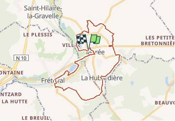
Randonnée V.T.T. de 16,5 km à découvrir à Centre-Val de Loire, Loir-et-Cher, Morée. Cette randonnée est proposée par tracegps.

Description

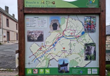
Circuit proposé par le Syndicat d’Initiative du Loir Haut-Vendômois. Départ du parking du pont du Loir à Morée.

Profil altimétrique

Photos

Localisation

Pays :
France
Région :
Centre-Val de Loire
Département/Province :
Loir-et-Cher
Commune :
Morée
Localité :
Unknown
Départ:(Dec)
Départ:(UTM)
367979 ; 5306952 (31T) N.

Randonnées à proximité

Randonnée Marche Fréteval - Fréteval - Photo
Marche
guydu41

Marche

Moyen
Fréteval, Centre-Val de Loire, Loir-et-Cher, France
10,8 km | 12,5 km-effort
2h 50min
Oui
Randonnée Marche Saint-Hilaire-la-Gravelle - Saint-Hilaire-la-Gravelle - Entre Loir et étangs  - Photo
Marche
guydu41

Marche

Facile
Saint-Hilaire-la-Gravelle, Centre-Val de Loire, Loir-et-Cher, France
16,5 km | 18,9 km-effort
4h 44min
Oui
Randonnée Marche Fréteval - Fréteval - L'histoire en chemin - Photo
Marche
guydu41

Marche

Facile
Fréteval, Centre-Val de Loire, Loir-et-Cher, France
19,7 km | 22 km-effort
6h 25min
Oui
Randonnée Vélo Fréteval - Circuit des 2 coteaux - Fréteval - Photo
Vélo
tracegps

Vélo

Difficile
Fréteval, Centre-Val de Loire, Loir-et-Cher, France
48 km | 54 km-effort
3h 0min
Oui
Randonnée Marche Fréteval - freteval 12 kms - Photo
Marche
migauthi

Marche

Très facile
Fréteval, Centre-Val de Loire, Loir-et-Cher, France
12,3 km | 14,1 km-effort
2h 44min
Oui
Randonnée Marche Fréteval - Freteval 27022022 - Photo
Marche
laurence41

Marche

Très difficile
Fréteval, Centre-Val de Loire, Loir-et-Cher, France
27 km | 30 km-effort
5h 20min
Oui
Randonnée A pied Fréteval - Randonnée Fréteval-Morée - Photo
A pied
Jean LABADIE

A pied

Moyen
Fréteval, Centre-Val de Loire, Loir-et-Cher, France
19,5 km | 22 km-effort
5h 1min
Oui
Randonnée Marche Fréteval - freteval david - Photo
Marche
richardlelot

Marche

Très facile
Fréteval, Centre-Val de Loire, Loir-et-Cher, France
14,2 km | 16,8 km-effort
2h 15min
Oui
Randonnée Moteur Morée - rendo bruno - Photo
Moteur
ludo41

Moteur

Moyen
Morée, Centre-Val de Loire, Loir-et-Cher, France
66 km | 73 km-effort
3h 48min
Oui


Fermer
Mes abonnements