Randonnée Marche Ponts sur Seulles - Pierrepont  (sur les pas des c - Photo

Pierrepont (sur les pas des c

 phi14
phi14

Utilisateur

© OpenStreetMap contributors
Longueur
Longueur
9,2 km
Altitude max
Altitude max
46 m
Dénivelé positif
Dénivelé positif
108 m
Km-Effort
Km-Effort  
10,6 km
Altitude min
Altitude min
5 m
Dénivelé négatif
Dénivelé négatif
101 m
Boucle
Boucle
Oui
Date de création :
2019-01-15 19:45:50.086
Dernière modification :
2019-01-15 19:45:50.086

(0 Avis)

Marche
Marche
2h20
Difficulté : Très facile

Scannez ce code QR pour ouvrir la randonnée dans l'application SityTrail

Application GPS de randonnée GRATUITE

Logo SityTrail SityTrail

IGN / Instituts géographiques

Télécharger SityTrail sur l'App Store Télécharger SityTrail sur Google Play

Logo SityTrail SityTrail World

Le monde est à vous

Télécharger SityTrail sur l'App Store Télécharger SityTrail sur Google Play Télécharger SityTrail sur Huawei AppGallery

À propos

Randonnée Marche de 9,2 km à découvrir à Normandie, Calvados, Ponts sur Seulles. Cette randonnée est proposée par phi14.

Description

Ballade très agréable permettant de découvrir de beaux villages.(sur les pas des carriers).

Profil altimétrique

Points d'intérêt

Point d'intérêt Ponts sur Seulles - pic-nic - Photo
phi14
PONTS SUR SEULLES 

Localisation

Pays :
France
Région :
Normandie
Département/Province :
Calvados
Commune :
Ponts sur Seulles
Localité :
Lantheuil
Départ:(Dec)
Départ:(UTM)
681661 ; 5461108 (30U) N.

Randonnées à proximité

Randonnée A pied Le Fresne-Camilly - autours de Fresne-Camilly, Fontaine Henry - Photo
A pied
Privatb

A pied

Moyen
(1)
Le Fresne-Camilly, Normandie, Calvados, France
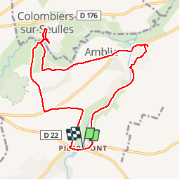
18,8 km | 21 km-effort
4h 50min
Oui
Randonnée Marche Fontaine-Henry - Fontaine-Henry-Claude - Photo
Marche
gr1346

Marche

Facile
(1)
Fontaine-Henry, Normandie, Calvados, France
7,8 km | 9,1 km-effort
2h 1min
Oui
Randonnée V.T.T. Creully sur Seulles - creuilly- asnelles - Photo
V.T.T.
mouss65

V.T.T.

Moyen
Creully sur Seulles, Normandie, Calvados, France
44 km | 49 km-effort
2h 42min
Oui
Randonnée sport Cairon - Départ Cairon  - Photo
sport
papylou7

sport

Très facile
Cairon, Normandie, Calvados, France
14,1 km | 15,9 km-effort
Inconnu
Oui
Randonnée V.T.T. Fontaine-Henry - reco vtt photo CTDCCR2016 - Photo
V.T.T.
mouss65

V.T.T.

Facile
Fontaine-Henry, Normandie, Calvados, France
14,1 km | 16,1 km-effort
1h 9min
Non
Randonnée A pied Fontaine-Henry - j 3 fontai henry   - Photo
A pied
chrisdouville

A pied

Facile
Fontaine-Henry, Normandie, Calvados, France
8,9 km | 10,6 km-effort
2h 24min
Oui
Randonnée Marche Cairon - cairon annick - Photo
Marche
gr1346

Marche

Moyen
Cairon, Normandie, Calvados, France
7,6 km | 8,2 km-effort
2h 5min
Oui
Randonnée Marche Thaon - Thaon - Photo
Marche
papylou7

Marche

Facile
Thaon, Normandie, Calvados, France
17,9 km | 19,9 km-effort
3h 46min
Oui
Randonnée V.T.T. Cairon - Cairon-la mer  - Photo
V.T.T.
memeche

V.T.T.

Très difficile
Cairon, Normandie, Calvados, France
46 km | 50 km-effort
4h 24min
Oui


Fermer
Mes abonnements