Randonnée Marche Chennebrun - Circuit des Normands - Chennebrun - Photo

Circuit des Normands - Chennebrun

 tracegps
tracegps

Utilisateur

© OpenStreetMap contributors
Longueur
Longueur
5,5 km
Altitude max
Altitude max
219 m
Dénivelé positif
Dénivelé positif
34 m
Km-Effort
Km-Effort  
5,9 km
Altitude min
Altitude min
196 m
Dénivelé négatif
Dénivelé négatif
34 m
Boucle
Boucle
Oui
Date de création :
2014-12-10 00:00:00.0
Dernière modification :
2014-12-10 00:00:00.0

(0 Avis)

Marche
Marche
1h19
Difficulté : Facile

Scannez ce code QR pour ouvrir la randonnée dans l'application SityTrail

Application GPS de randonnée GRATUITE

Logo SityTrail SityTrail

IGN / Instituts géographiques

Télécharger SityTrail sur l'App Store Télécharger SityTrail sur Google Play

Logo SityTrail SityTrail World

Le monde est à vous

Télécharger SityTrail sur l'App Store Télécharger SityTrail sur Google Play Télécharger SityTrail sur Huawei AppGallery

À propos

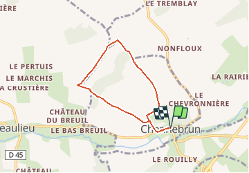
Randonnée Marche de 5,5 km à découvrir à Normandie, Eure, Chennebrun. Cette randonnée est proposée par tracegps.

Description

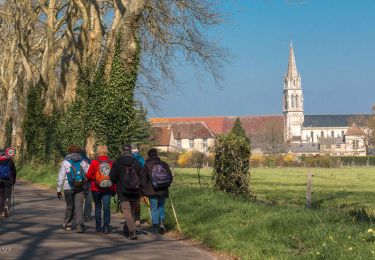
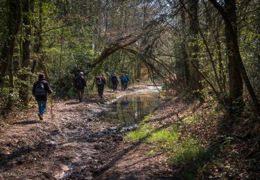
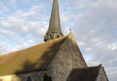
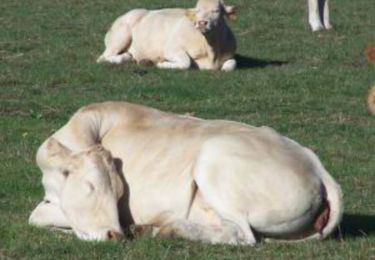
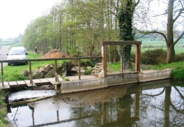
Circuit proposé par l'Office de Tourisme du Pays d'Avre, d'Eure et d'Iton. Une promenade au milieux des champs. Prenez le temps d'admirer Chennebrun, son château, son église, ses ruelles et les fossés royaux (à coté desquels on peut pique-niquer). Départ de la place de Chennebrun Retrouvez le circuit et son descriptif sur le site de l'Office de Tourisme du Pays d'Avre, d'Eure et d'Iton.

Profil altimétrique

Photos

Localisation

Pays :
France
Région :
Normandie
Département/Province :
Eure
Commune :
Chennebrun
Localité :
Unknown
Départ:(Dec)
Départ:(UTM)
336835 ; 5394243 (31U) N.

Randonnées à proximité

Randonnée Marche Charencey - Saint-Maurice-lès-Charencey - Soligny-la-Trappe 25 km - Photo
Marche

Marche

Moyen
Charencey, Normandie, Orne, France
24 km | 28 km-effort
6h 22min
Non
Randonnée Marche Charencey - Saint-Maurice-les-Charencey - Tourouvre 28 km - Photo
Marche

Marche

Facile
Charencey, Normandie, Orne, France
26 km | 30 km-effort
6h 53min
Non
Randonnée Marche Saint-Christophe-sur-Avre - Les Fossés Royaux - St Christophe-sur-Avre - Photo
Marche
tracegps

Marche

Facile
Saint-Christophe-sur-Avre, Normandie, Eure, France
7,2 km | 8 km-effort
1h 49min
Oui
Randonnée Marche Gournay-le-Guérin - Circuit des Fermes -  Gournay-le-Guérin  - Photo
Marche
tracegps

Marche

Facile
Gournay-le-Guérin, Normandie, Eure, France
7,3 km | 7,9 km-effort
1h 49min
Oui
Randonnée Marche Chennebrun - Circuit des Normands - Chennebrun  - Photo
Marche
tracegps

Marche

Facile
Chennebrun, Normandie, Eure, France
5,5 km | 5,9 km-effort
1h 19min
Oui
Randonnée Marche Beaulieu - Beaulieu - D'un calvaire à l'autre 6,3 km - Photo
Marche
ODDAD78

Marche

Moyen
Beaulieu, Normandie, Orne, France
5,7 km | 6,3 km-effort
1h 25min
Oui
Randonnée Marche Beaulieu - Beaulieu - Autour du bourg 4,6 km - Photo
Marche
ODDAD78

Marche

Facile
Beaulieu, Normandie, Orne, France
4,2 km | 4,6 km-effort
1h 2min
Oui
Randonnée Marche Saint-Christophe-sur-Avre - st Christophe - Photo
Marche
bipf

Marche

Très facile
Saint-Christophe-sur-Avre, Normandie, Eure, France
510 m | 556 m-effort
15min
Non
Randonnée Marche Charencey - TPE 2018 Etape 3 Saint-Maurice-lès-Charencey - Tourouvre 26,1Km - Photo
Marche
ODDAD78

Marche

Moyen
Charencey, Normandie, Orne, France
26 km | 31 km-effort
6h 43min
Non


Fermer
Mes abonnements