Randonnée Marche Saint-Christophe-sur-Avre - st Christophe - Photo
 bipf
bipf

Utilisateur

© OpenStreetMap contributors
Longueur
Longueur
510 m
Altitude max
Altitude max
210 m
Dénivelé positif
Dénivelé positif
1 m
Km-Effort
Km-Effort  
556 m
Altitude min
Altitude min
199 m
Dénivelé négatif
Dénivelé négatif
11 m
Boucle
Boucle
Non
Date de création :
2020-09-27 09:42:48.422
Dernière modification :
2020-09-28 06:44:50.9

(0 Avis)

Marche
Marche
15m
Difficulté : Très facile

Scannez ce code QR pour ouvrir la randonnée dans l'application SityTrail

Application GPS de randonnée GRATUITE

Logo SityTrail SityTrail

IGN / Instituts géographiques

Télécharger SityTrail sur l'App Store Télécharger SityTrail sur Google Play

Logo SityTrail SityTrail World

Le monde est à vous

Télécharger SityTrail sur l'App Store Télécharger SityTrail sur Google Play Télécharger SityTrail sur Huawei AppGallery

À propos

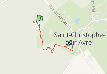
Randonnée Marche de 510 m à découvrir à Normandie, Eure, Saint-Christophe-sur-Avre. Cette randonnée est proposée par bipf.

Profil altimétrique

Photos

Localisation

Pays :
France
Région :
Normandie
Département/Province :
Eure
Commune :
Saint-Christophe-sur-Avre
Localité :
Unknown
Départ:(UTM)
339042 ; 5396437 (31U) N.

Randonnées à proximité

Randonnée Marche Chennebrun - Circuit des Normands - Chennebrun - Photo
Marche
tracegps

Marche

Facile
Chennebrun, Normandie, Eure, France
5,5 km | 5,9 km-effort
1h 19min
Oui
Randonnée Vélo Les Barils - Circuit découverte de villages normands - Les Barils - Photo
Vélo
tracegps

Vélo

Facile
Les Barils, Normandie, Eure, France
17,9 km | 19,7 km-effort
1h 15min
Oui
Randonnée Marche Les Barils - ballade autour de center parc les bois franc - Photo
Marche
franckaille

Marche

Très facile
Les Barils, Normandie, Eure, France
12,9 km | 14,1 km-effort
2h 7min
Non
Randonnée Marche Saint-Christophe-sur-Avre - Les Fossés Royaux - St Christophe-sur-Avre - Photo
Marche
tracegps

Marche

Facile
Saint-Christophe-sur-Avre, Normandie, Eure, France
7,2 km | 8 km-effort
1h 49min
Oui
Randonnée Marche Gournay-le-Guérin - Circuit des Fermes -  Gournay-le-Guérin  - Photo
Marche
tracegps

Marche

Facile
Gournay-le-Guérin, Normandie, Eure, France
7,3 km | 7,9 km-effort
1h 49min
Oui
Randonnée Marche Chennebrun - Circuit des Normands - Chennebrun  - Photo
Marche
tracegps

Marche

Facile
Chennebrun, Normandie, Eure, France
5,5 km | 5,9 km-effort
1h 19min
Oui
Randonnée Marche Beaulieu - Beaulieu - D'un calvaire à l'autre 6,3 km - Photo
Marche
ODDAD78

Marche

Moyen
Beaulieu, Normandie, Orne, France
5,7 km | 6,3 km-effort
1h 25min
Oui
Randonnée Marche Beaulieu - Beaulieu - Autour du bourg 4,6 km - Photo
Marche
ODDAD78

Marche

Facile
Beaulieu, Normandie, Orne, France
4,2 km | 4,6 km-effort
1h 2min
Oui
Randonnée Marche Pullay - Pullay Bois Francs 10.1 Km - Photo
Marche
ODDAD78

Marche

Facile
Pullay, Normandie, Eure, France
10,1 km | 11 km-effort
2h 27min
Oui


Fermer
Mes abonnements