Randonnée V.T.T. Saint-André-d'Huiriat -  Rando Saint André d'Huiriat 2012 - Photo

Rando Saint André d'Huiriat 2012

 tracegps
tracegps

Utilisateur

© OpenStreetMap contributors
Longueur
Longueur
44 km
Altitude max
Altitude max
260 m
Dénivelé positif
Dénivelé positif
399 m
Km-Effort
Km-Effort  
50 km
Altitude min
Altitude min
182 m
Dénivelé négatif
Dénivelé négatif
400 m
Boucle
Boucle
Oui
Date de création :
2014-12-10 00:00:00.0
Dernière modification :
2014-12-10 00:00:00.0

(0 Avis)

V.T.T.
V.T.T.
2h30
Difficulté : Facile

Scannez ce code QR pour ouvrir la randonnée dans l'application SityTrail

Application GPS de randonnée GRATUITE

Logo SityTrail SityTrail

IGN / Instituts géographiques

Télécharger SityTrail sur l'App Store Télécharger SityTrail sur Google Play

Logo SityTrail SityTrail World

Le monde est à vous

Télécharger SityTrail sur l'App Store Télécharger SityTrail sur Google Play Télécharger SityTrail sur Huawei AppGallery

À propos

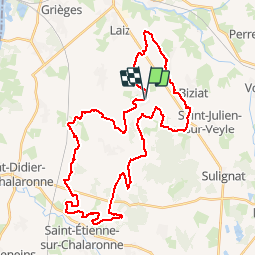
Randonnée V.T.T. de 44 km à découvrir à Auvergne-Rhône-Alpes, Ain, Saint-André-d'Huiriat. Cette randonnée est proposée par tracegps.

Description

Circuit avec peu de dénivelé et très roulant.

Profil altimétrique

Photos

Localisation

Pays :
France
Région :
Auvergne-Rhône-Alpes
Département/Province :
Ain
Commune :
Saint-André-d'Huiriat
Localité :
Unknown
Départ:(Dec)
Départ:(UTM)
647367 ; 5119480 (31T) N.

Randonnées à proximité

Randonnée Randonnée équestre Laiz - 2023-05-25_09h39m05_boucle_30_km_vonnas-7413273-1684955259-744 - Photo
Randonnée équestre
azipat

Randonnée équestre

Difficile
Laiz, Auvergne-Rhône-Alpes, Ain, France
29 km | 33 km-effort
4h 21min
Oui
Randonnée Randonnée équestre Laiz - 2023-05-25_09h38m20_laiz_vesines_34_km-16835074-1684955197-729 - Photo
Randonnée équestre
azipat

Randonnée équestre

Difficile
(1)
Laiz, Auvergne-Rhône-Alpes, Ain, France
34 km | 38 km-effort
4h 57min
Non
Randonnée Randonnée équestre Laiz - 2023-05-25_09h36m55_boucle_illiat_30km-13377883-1684955247-776 - Photo
Randonnée équestre
azipat

Randonnée équestre

Difficile
Laiz, Auvergne-Rhône-Alpes, Ain, France
29 km | 34 km-effort
4h 24min
Non
Randonnée Marche Grièges - Griéges / Cruzille  - Photo
Marche
daniel delorme

Marche

Très facile
Grièges, Auvergne-Rhône-Alpes, Ain, France
7,2 km | 8 km-effort
1h 43min
Oui
Randonnée Randonnée équestre Laiz - Boucle Heike Vonnas - Photo
Randonnée équestre
poneys

Randonnée équestre

Difficile
Laiz, Auvergne-Rhône-Alpes, Ain, France
28 km | 31 km-effort
4h 7min
Oui
Randonnée Marche Illiat - Illat - Photo
Marche
janussity

Marche

Facile
Illiat, Auvergne-Rhône-Alpes, Ain, France
4,9 km | 5,7 km-effort
1h 15min
Oui
Randonnée Marche Saint-Jean-sur-Veyle - Saint Jean sur Veyle - Photo
Marche
chapeland

Marche

Facile
Saint-Jean-sur-Veyle, Auvergne-Rhône-Alpes, Ain, France
6,4 km | 7,1 km-effort
1h 56min
Oui
Randonnée Marche Perrex - Perrex  - Photo
Marche
chapeland

Marche

Moyen
Perrex, Auvergne-Rhône-Alpes, Ain, France
8 km | 8,6 km-effort
2h 14min
Oui
Randonnée Randonnée équestre Laiz - Boucle Laiz 4 - Replonges - Photo
Randonnée équestre
poneys

Randonnée équestre

Difficile
Laiz, Auvergne-Rhône-Alpes, Ain, France
32 km | 35 km-effort
4h 34min
Oui


Fermer
Mes abonnements