Randonnée V.T.T. Barbazan - Les sites touristiques n ° 13 - Barbazan - Photo

Les sites touristiques n ° 13 - Barbazan

 tracegps
tracegps

Utilisateur

© OpenStreetMap contributors
Longueur
Longueur
12,2 km
Altitude max
Altitude max
478 m
Dénivelé positif
Dénivelé positif
139 m
Km-Effort
Km-Effort  
14,1 km
Altitude min
Altitude min
438 m
Dénivelé négatif
Dénivelé négatif
140 m
Boucle
Boucle
Oui
Date de création :
2014-12-10 00:00:00.0
Dernière modification :
2014-12-10 00:00:00.0

(0 Avis)

V.T.T.
V.T.T.
1h15
Difficulté : Facile

Scannez ce code QR pour ouvrir la randonnée dans l'application SityTrail

Application GPS de randonnée GRATUITE

Logo SityTrail SityTrail

IGN / Instituts géographiques

Télécharger SityTrail sur l'App Store Télécharger SityTrail sur Google Play

Logo SityTrail SityTrail World

Le monde est à vous

Télécharger SityTrail sur l'App Store Télécharger SityTrail sur Google Play Télécharger SityTrail sur Huawei AppGallery

À propos

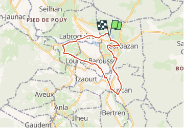
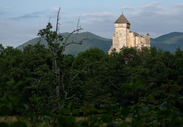
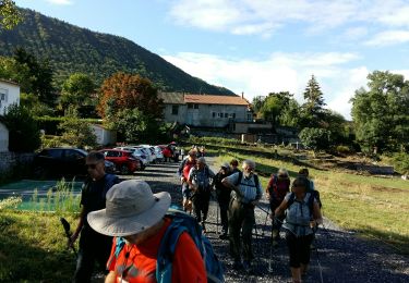
Randonnée V.T.T. de 12,2 km à découvrir à Occitanie, Haute-Garonne, Barbazan. Cette randonnée est proposée par tracegps.

Description

Une collection de 10 fiches de randonnées pédestres et 13 fiches dédiées au VTT vous sont proposées par la Communauté de communes du Haut Comminges. Départ du lac de Barbazan.

Profil altimétrique

Photos

Localisation

Pays :
France
Région :
Occitanie
Département/Province :
Haute-Garonne
Commune :
Barbazan
Localité :
Unknown
Départ:(Dec)
Départ:(UTM)
305707 ; 4767721 (31T) N.

Randonnées à proximité

Randonnée Marche Ardiège - Promenade autour d'Ardiège et de Cier de Rivière - Photo
Marche
tracegps

Marche

Facile
(1)
Ardiège, Occitanie, Haute-Garonne, France
5 km | 6,4 km-effort
1h 15min
Oui
Randonnée Marche Saint-Bertrand-de-Comminges - Autour de Saint Bertrand de Comminges - Photo
Marche
tracegps

Marche

Difficile
(1)
Saint-Bertrand-de-Comminges, Occitanie, Haute-Garonne, France
10,2 km | 17,1 km-effort
3h 30min
Oui
Randonnée Marche Seilhan - Tour de Seilhan - Photo
Marche
tracegps

Marche

Facile
(1)
Seilhan, Occitanie, Haute-Garonne, France
5,9 km | 7,7 km-effort
1h 30min
Oui
Randonnée Marche Barbazan - Tour de Barbazan - Photo
Marche
tracegps

Marche

Facile
(2)
Barbazan, Occitanie, Haute-Garonne, France
5,7 km | 7,3 km-effort
1h 30min
Oui
Randonnée Marche Antichan - sommet d'Herbe Rouge en boucle depuis Antichan  - Photo
Marche
GUIDE
lhomme.ph

Marche

Moyen
Antichan, Occitanie, Hautes-Pyrénées, France
11,4 km | 20 km-effort
5h 47min
Oui
Randonnée A pied Saint-Bertrand-de-Comminges - Saint-Bertrand-de-Comminges : au coeur du Comminges - Photo
A pied
PRO

A pied

Facile
Saint-Bertrand-de-Comminges, Occitanie, Haute-Garonne, France
10,1 km | 17,1 km-effort
3h 52min
Oui
Randonnée V.T.T. Sauveterre-de-Comminges - sunday spin 8/6/14 - Photo
V.T.T.
ray23

V.T.T.

Difficile
(2)
Sauveterre-de-Comminges, Occitanie, Haute-Garonne, France
18,2 km | 26 km-effort
2h 10min
Oui
Randonnée Marche Seilhan - bord de Garonne vers Labroquère  - Photo
Marche
GUIDE
lhomme.ph

Marche

Moyen
Seilhan, Occitanie, Haute-Garonne, France
9,5 km | 11,4 km-effort
2h 51min
Oui
Randonnée A pied Barbazan - BARBAZAN  le refuge saint-martin G3 Fait
A pied
GUIDE
marmotte65

A pied

Facile
Barbazan, Occitanie, Haute-Garonne, France
11,2 km | 18,1 km-effort
3h 34min
Oui


Fermer
Mes abonnements