Randonnée Vélo La Ferté-Vidame - La Chapelle de Réveillon - La Ferté Vidame - Photo

La Chapelle de Réveillon - La Ferté Vidame

 tracegps
tracegps

Utilisateur

© OpenStreetMap contributors
Longueur
Longueur
16,7 km
Altitude max
Altitude max
283 m
Dénivelé positif
Dénivelé positif
141 m
Km-Effort
Km-Effort  
18,5 km
Altitude min
Altitude min
228 m
Dénivelé négatif
Dénivelé négatif
141 m
Boucle
Boucle
Oui
Date de création :
2014-12-10 00:00:00.0
Dernière modification :
2014-12-10 00:00:00.0

(0 Avis)

Vélo
Vélo
2h00
Difficulté : Facile

Scannez ce code QR pour ouvrir la randonnée dans l'application SityTrail

Application GPS de randonnée GRATUITE

Logo SityTrail SityTrail

IGN / Instituts géographiques

Télécharger SityTrail sur l'App Store Télécharger SityTrail sur Google Play

Logo SityTrail SityTrail World

Le monde est à vous

Télécharger SityTrail sur l'App Store Télécharger SityTrail sur Google Play Télécharger SityTrail sur Huawei AppGallery

À propos

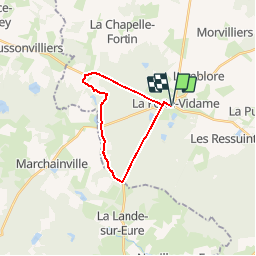
Randonnée Vélo de 16,7 km à découvrir à Centre-Val de Loire, Eure-et-Loir, La Ferté-Vidame. Cette randonnée est proposée par tracegps.

Description

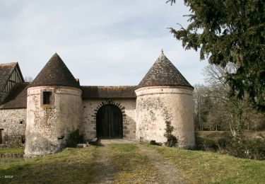
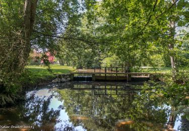
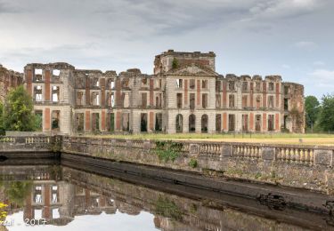
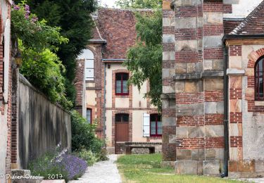
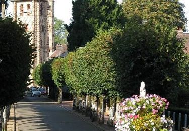
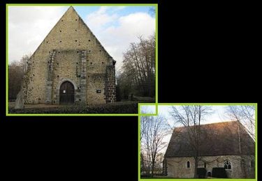
Circuit proposé par la Communauté de communes de l’Orée du Perche et le syndicat d'initiative de La Ferté-Vidame. Un circuit familial sans difficulté, ombragé et verdoyant dans l’univers calme et intime des forêts préservées du Parc Naturel Régional du Perche. La chapelle Saint-Pierre de Réveillon, joyau du XIIIème siècle serti dans un écrin de sapins, est bordée par le ruisseau de Buternay. À l’intérieur, des peintures murales du XVIème siècle, récemment dégagées de leur badigeon de chaux, constituent un centre d’intérêt archéologique et artistique majeur. Départ de l'église de la Ferté-Vidame. Retrouvez le circuit et son descriptif sur le site du Comité départemental de l’Eure-et-Loir.

Profil altimétrique

Photos

Localisation

Pays :
France
Région :
Centre-Val de Loire
Département/Province :
Eure-et-Loir
Commune :
La Ferté-Vidame
Localité :
Unknown
Départ:(Dec)
Départ:(UTM)
345140 ; 5386293 (31U) N.

Randonnées à proximité

Randonnée Marche La Ferté-Vidame - La Ferté-Vidame - Longny-au-Perche (Longny-les-Villages) 23 km - Photo
Marche

Marche

Très difficile
La Ferté-Vidame, Centre-Val de Loire, Eure-et-Loir, France
23 km | 25 km-effort
5h 35min
Non
Randonnée Marche La Ferté-Vidame - La Ferté-Vidame - Tourouvre (TCP) 29 km - Photo
Marche

Marche

Moyen
La Ferté-Vidame, Centre-Val de Loire, Eure-et-Loir, France
29 km | 33 km-effort
7h 9min
Non
Randonnée Marche La Ferté-Vidame - La Ferté-Vidame - Moutiers-au-Perche (TCP) 28 km - Photo
Marche

Marche

Facile
La Ferté-Vidame, Centre-Val de Loire, Eure-et-Loir, France
28 km | 32 km-effort
7h 1min
Non
Randonnée Marche La Ferté-Vidame - La Ferté-Vidame - Saint-Maurice-lès-Charencey 15 km - Photo
Marche

Marche

Facile
(1)
La Ferté-Vidame, Centre-Val de Loire, Eure-et-Loir, France
15,3 km | 16,9 km-effort
3h 34min
Non
Randonnée Marche La Ferté-Vidame - La Ferté Vidame 07.86 - Photo
Marche
togolo28

Marche

Facile
(1)
La Ferté-Vidame, Centre-Val de Loire, Eure-et-Loir, France
8,2 km | 9,1 km-effort
1h 58min
Oui
Randonnée Marche La Ferté-Vidame - La Ferté-Vidame - Senonches 17 km - Photo
Marche

Marche

Facile
La Ferté-Vidame, Centre-Val de Loire, Eure-et-Loir, France
16,7 km | 18,5 km-effort
4h 36min
Non
Randonnée V.T.T. La Ferté-Vidame - Autour de la forêt (Etape 1) -  La Ferté-Vidame - Photo
V.T.T.
tracegps

V.T.T.

Moyen
(1)
La Ferté-Vidame, Centre-Val de Loire, Eure-et-Loir, France
19,5 km | 22 km-effort
2h 0min
Non
Randonnée Marche La Ferté-Vidame - Autour de la forêt (Etape 1) -  La Ferté-Vidame - Photo
Marche
tracegps

Marche

Difficile
La Ferté-Vidame, Centre-Val de Loire, Eure-et-Loir, France
19,5 km | 22 km-effort
5h 19min
Non
Randonnée V.T.T. La Ferté-Vidame - Sentier Saint Hubert - La Ferté Vidame - Photo
V.T.T.
tracegps

V.T.T.

Facile
La Ferté-Vidame, Centre-Val de Loire, Eure-et-Loir, France
11,3 km | 12,5 km-effort
1h 0min
Oui


Fermer
Mes abonnements