Randonnée V.T.T. Langoiran - 33-Langoiran-20120826 - Photo
 Gus64
Gus64

Utilisateur

© OpenStreetMap contributors
Longueur
Longueur
43 km
Altitude max
Altitude max
108 m
Dénivelé positif
Dénivelé positif
906 m
Km-Effort
Km-Effort  
55 km
Altitude min
Altitude min
2 m
Dénivelé négatif
Dénivelé négatif
906 m
Boucle
Boucle
Oui
Date de création :
2014-12-10 00:00:00.0
Dernière modification :
2014-12-10 00:00:00.0

(0 Avis)

V.T.T.
V.T.T.
3h35
Difficulté : Moyen

Scannez ce code QR pour ouvrir la randonnée dans l'application SityTrail

Application GPS de randonnée GRATUITE

Logo SityTrail SityTrail

IGN / Instituts géographiques

Télécharger SityTrail sur l'App Store Télécharger SityTrail sur Google Play

Logo SityTrail SityTrail World

Le monde est à vous

Télécharger SityTrail sur l'App Store Télécharger SityTrail sur Google Play Télécharger SityTrail sur Huawei AppGallery

À propos

Randonnée V.T.T. de 43 km à découvrir à Nouvelle-Aquitaine, Gironde, Langoiran. Cette randonnée est proposée par Gus64.

Description

Via Haut Langoiran,Lestiac,Ste Anne,Capian et Minguet.

Profil altimétrique

Localisation

Pays :
France
Région :
Nouvelle-Aquitaine
Département/Province :
Gironde
Commune :
Langoiran
Localité :
Unknown
Départ:(Dec)
Départ:(UTM)
705789 ; 4953631 (30T) N.

Randonnées à proximité

Randonnée V.T.T. Saint-Caprais-de-Bordeaux - St Caprais - Madirac - Photo
V.T.T.
FranckBag

V.T.T.

Moyen
(1)
Saint-Caprais-de-Bordeaux, Nouvelle-Aquitaine, Gironde, France
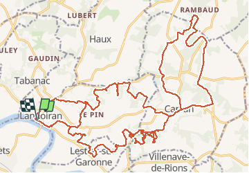
33 km | 42 km-effort
2h 43min
Oui
Randonnée Marche Rions - Rions est - Photo
Marche
bedous

Marche

Moyen
Rions, Nouvelle-Aquitaine, Gironde, France
13,2 km | 16,2 km-effort
4h 1min
Oui
Randonnée Marche Lestiac-sur-Garonne - aze - Photo
Marche
PatrickBEGUIN

Marche

Facile
Lestiac-sur-Garonne, Nouvelle-Aquitaine, Gironde, France
4,5 km | 4,8 km-effort
2h 34min
Non
Randonnée Marche Le Tourne - langoiran - Photo
Marche
bedous

Marche

Facile
Le Tourne, Nouvelle-Aquitaine, Gironde, France
17,8 km | 24 km-effort
4h 12min
Non
Randonnée Marche Lestiac-sur-Garonne - lestiac   - Photo
Marche
phil33

Marche

Très facile
Lestiac-sur-Garonne, Nouvelle-Aquitaine, Gironde, France
9,4 km | 11,3 km-effort
3h 2min
Oui
Randonnée V.T.T. Haux - 33-haux-20120527 - Photo
V.T.T.
Gus64

V.T.T.

Difficile
Haux, Nouvelle-Aquitaine, Gironde, France
32 km | 41 km-effort
3h 0min
Oui
Randonnée Marche Tabanac - languaran  - Photo
Marche
jara

Marche

Très facile
Tabanac, Nouvelle-Aquitaine, Gironde, France
9,8 km | 12,1 km-effort
2h 54min
Oui
Randonnée Marche Haux - haux - Photo
Marche
gerardbarreau

Marche

Très facile
Haux, Nouvelle-Aquitaine, Gironde, France
11,8 km | 15,3 km-effort
4h 1min
Oui
Randonnée Randonnée équestre Portets - Florence CB arbanats  - Photo
Randonnée équestre
kikiumer

Randonnée équestre

Très facile
Portets, Nouvelle-Aquitaine, Gironde, France
15,4 km | 17,1 km-effort
2h 49min
Oui


Fermer
Mes abonnements