![](/images/other/stat-length.png)
![Randonnée Moteur Stavelot - Visite ancien tracé circuit Francorchamps - Photo](https://media.geolcdn.com/t/1900/400/ext.pjpeg?maxdim=2&url=https%3A%2F%2Fstatic1.geolcdn.com%2Fsiteimages%2Fupload%2Ffiles%2F15247431544x4.jpg)
Visite ancien tracé circuit Francorchamps
cwuidard
Utilisateur
![Longueur](/images/other/stat-length.png)
Longueur
14,2 km
![Altitude max](https://static1.geolcdn.com/siteimages/upload/files/1508320355ic_sort_altitude_max_24dp.png)
Altitude max
483 m
![Dénivelé positif](https://static1.geolcdn.com/siteimages/upload/files/1508320355ic_sort_den_pos_24dp.png)
Dénivelé positif
211 m
![Km-Effort](/images/other/stat-length.png)
Km-Effort
17,3 km
![Altitude min](https://static1.geolcdn.com/siteimages/upload/files/1508320355ic_sort_altitude_min_24dp.png)
Altitude min
293 m
![Dénivelé négatif](https://static1.geolcdn.com/siteimages/upload/files/1508320355ic_sort_den_neg_24dp.png)
Dénivelé négatif
303 m
![Boucle](https://static1.geolcdn.com/siteimages/upload/files/16400158638029165_repeat_loop_refresh_sync_direction_icon.png)
Boucle
Non
Date de création :
2014-12-10 00:00:00.0
Dernière modification :
2014-12-10 00:00:00.0
![Moteur](https://static1.geolcdn.com/sitytour/trail-icons/400.png)
1h00
Difficulté : Inconnu
![Scannez ce code QR pour ouvrir la randonnée dans l'application SityTrail](https://capi.geolives.com/qq0zvz2zws4bq2lad0pu/sitytour/trails/154369/qr.png?size=200)
Application GPS de randonnée GRATUITE
À propos
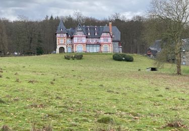
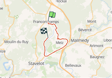
Randonnée Moteur de 14,2 km à découvrir à Wallonie, Liège, Stavelot. Cette randonnée est proposée par cwuidard.
Description
La visite commentée de l'ancien tracé du circuit sera organisée lors de la sortie de 22/09.
Point de départ au Racing Hôtel, 1 route du Circuit à 4970 Francorchamps.
Localisation
Pays :
Belgique
Région :
Wallonie
Département/Province :
Liège
Commune :
Stavelot
Localité :
Francorchamps
Départ:(Dec)
Départ:(UTM)
709923 ; 5593161 (31U) N.
Commentaires
Randonnées à proximité
![Randonnée Marche Stavelot - 20211213 - Hockay 5.4 Km - Photo](https://media.geolcdn.com/t/375/260/ext.jpg?maxdim=2&url=https%3A%2F%2Fmedia.geolcdn.com%2Ff%2F2af4f064-4123-4bf2-a6f0-d07b2843bf6f.JPG)
![Marche Marche](https://static1.geolcdn.com/sitytour/trail-icons/101.png)
20211213 - Hockay 5.4 Km
Marche
Moyen
(3)
Stavelot,
Wallonie,
Liège,
Belgique
![](/images/other/stat-length.png)
5,1 km | 6,6 km-effort
1h 34min
![](https://static1.geolcdn.com/siteimages/upload/files/16400158638029165_repeat_loop_refresh_sync_direction_icon.png)
Oui
![Randonnée Marche Stavelot - Hockai ❄️☃️ - Photo](https://media.geolcdn.com/t/375/260/ext.jpg?maxdim=2&url=https%3A%2F%2Fmedia.geolcdn.com%2Ff%2Fa5e9d4f4-0133-456e-a4c0-187a5c868dc0.jpg)
![Marche Marche](https://static1.geolcdn.com/sitytour/trail-icons/101.png)
![Randonnée Marche Stavelot - Francorchamps - Photo](https://media.geolcdn.com/t/375/260/ext.jpg?maxdim=2&url=https%3A%2F%2Fmedia.geolcdn.com%2Ff%2F25022bf7-5f16-4f7a-a496-8bea46c46417.jpg)
![Marche Marche](https://static1.geolcdn.com/sitytour/trail-icons/101.png)
![Randonnée Marche Stavelot - Chemin des Sources |étape n°4 HOCKAI – HOËGNE – SOLWASTER - Photo](https://media.geolcdn.com/t/375/260/ext.jpg?maxdim=2&url=https%3A%2F%2Fmedia.geolcdn.com%2Ff%2Fb573e435-769d-4260-adb4-88571687d0e5.jpg)
![Marche Marche](https://static1.geolcdn.com/sitytour/trail-icons/101.png)
Chemin des Sources |étape n°4 HOCKAI – HOËGNE – SOLWASTER
Marche
Difficile
(1)
Stavelot,
Wallonie,
Liège,
Belgique
![](/images/other/stat-length.png)
15,1 km | 18,6 km-effort
4h 13min
![](https://static1.geolcdn.com/siteimages/upload/files/16400158638029165_repeat_loop_refresh_sync_direction_icon.png)
Non
![Randonnée Marche Stavelot - Chemin des Sources |étape n°2 FRANCORCHAMPS – COO – STAVELOT - Photo](https://media.geolcdn.com/t/375/260/ext.jpg?maxdim=2&url=https%3A%2F%2Fmedia.geolcdn.com%2Ff%2F6be923f6-252e-4736-a317-aac3802af958.jpg)
![Marche Marche](https://static1.geolcdn.com/sitytour/trail-icons/101.png)
Chemin des Sources |étape n°2 FRANCORCHAMPS – COO – STAVELOT
Marche
Très difficile
(1)
Stavelot,
Wallonie,
Liège,
Belgique
![](/images/other/stat-length.png)
24 km | 35 km-effort
7h 53min
![](https://static1.geolcdn.com/siteimages/upload/files/16400158638029165_repeat_loop_refresh_sync_direction_icon.png)
Non
![Randonnée Marche Stavelot - Francorchamps roannay rive gauche - Ruy retour rive droite - Photo](https://media.geolcdn.com/t/375/260/ext.jpg?maxdim=2&url=https%3A%2F%2Fmedia.geolcdn.com%2Ff%2F64e75e8f-5811-4b51-8561-04158e15268c.jpg)
![Marche Marche](https://static1.geolcdn.com/sitytour/trail-icons/101.png)
Francorchamps roannay rive gauche - Ruy retour rive droite
Marche
Moyen
(2)
Stavelot,
Wallonie,
Liège,
Belgique
![](/images/other/stat-length.png)
12,8 km | 17,1 km-effort
4h 0min
![](https://static1.geolcdn.com/siteimages/upload/files/16400158638029165_repeat_loop_refresh_sync_direction_icon.png)
Oui
![Randonnée Marche Spa - grand tour de la fagne depuis Malchamps - Photo](https://media.geolcdn.com/t/375/260/ext.jpg?maxdim=2&url=https%3A%2F%2Fmedia.geolcdn.com%2Ff%2F2251e14d-ae7a-4ea0-8644-29762dde1b20.jpg)
![Marche Marche](https://static1.geolcdn.com/sitytour/trail-icons/101.png)
grand tour de la fagne depuis Malchamps
Marche
Très facile
(2)
Spa,
Wallonie,
Liège,
Belgique
![](/images/other/stat-length.png)
8,3 km | 9,7 km-effort
2h 13min
![](https://static1.geolcdn.com/siteimages/upload/files/16400158638029165_repeat_loop_refresh_sync_direction_icon.png)
Oui
![Randonnée Marche Malmedy - malmedy . ferme libert . tro maret . ferme libert . malmedy par les crêtes - Photo](https://media.geolcdn.com/t/375/260/ext.jpg?maxdim=2&url=https%3A%2F%2Fmedia.geolcdn.com%2Ff%2F6c222aa1-844a-4917-af45-0da05eb40a0e.jpg)
![Marche Marche](https://static1.geolcdn.com/sitytour/trail-icons/101.png)
malmedy . ferme libert . tro maret . ferme libert . malmedy par les crêtes
Marche
Très facile
(1)
Malmedy,
Wallonie,
Liège,
Belgique
![](/images/other/stat-length.png)
13,1 km | 18,8 km-effort
4h 1min
![](https://static1.geolcdn.com/siteimages/upload/files/16400158638029165_repeat_loop_refresh_sync_direction_icon.png)
Oui
![Randonnée Marche Spa - Spa - Photo](https://media.geolcdn.com/t/375/260/ext.jpg?maxdim=2&url=https%3A%2F%2Fmedia.geolcdn.com%2Ff%2F34a34675-12f0-4187-8612-2eb0191af933.jpg)
![Marche Marche](https://static1.geolcdn.com/sitytour/trail-icons/101.png)