Randonnée Marche Bergen - 13km wandelen in De Maasduinen - Photo

13km wandelen in De Maasduinen

 WouterDrijfhout
WouterDrijfhout

Utilisateur

© OpenStreetMap contributors
Longueur
Longueur
13,7 km
Altitude max
Altitude max
33 m
Dénivelé positif
Dénivelé positif
92 m
Km-Effort
Km-Effort  
14,9 km
Altitude min
Altitude min
15 m
Dénivelé négatif
Dénivelé négatif
93 m
Boucle
Boucle
Oui
Date de création :
2018-07-20 18:40:15.282
Dernière modification :
2018-07-20 18:40:15.282

(0 Avis)

Marche
Marche
3h16
Difficulté : Très facile

Scannez ce code QR pour ouvrir la randonnée dans l'application SityTrail

Application GPS de randonnée GRATUITE

Logo SityTrail SityTrail

IGN / Instituts géographiques

Télécharger SityTrail sur l'App Store Télécharger SityTrail sur Google Play

Logo SityTrail SityTrail World

Le monde est à vous

Télécharger SityTrail sur l'App Store Télécharger SityTrail sur Google Play Télécharger SityTrail sur Huawei AppGallery

À propos

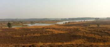
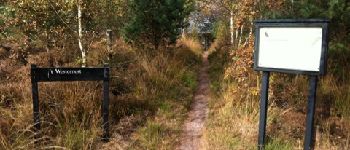
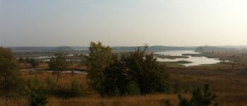
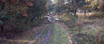
Randonnée Marche de 13,7 km à découvrir à Limbourg, Inconnu, Bergen. Cette randonnée est proposée par WouterDrijfhout.

Profil altimétrique

Photos

Points d'intérêt

Point d'intérêt Bergen - Oosten van Westmeer - Photo
WouterDrijfhout
Point d'intérêt Bergen - Westen tov Westmeer - Photo
WouterDrijfhout
Point d'intérêt Bergen - Ingang
WouterDrijfhout
Point d'intérêt Bergen - Dikkenberg - Photo
WouterDrijfhout
BERGEN 
Point d'intérêt Bergen - Infobord - Photo
WouterDrijfhout
BERGEN 
Point d'intérêt Bergen - Bankje in de zon - Photo
WouterDrijfhout
Point d'intérêt Bergen - Bijenkasten - Photo
WouterDrijfhout
BERGEN 

Localisation

Pays :
Pays-Bas
Région :
Limbourg
Département/Province :
Inconnu
Commune :
Bergen
Localité :
Unknown
Départ:(Dec)
Départ:(UTM)
303657 ; 5710126 (32U) N.

Randonnées à proximité

Randonnée A pied Bergen - De Hamert - Blauwe paaltjes - Photo
A pied
PRO

A pied

Facile
Bergen, Limbourg, Inconnu, Pays-Bas
3,7 km | 4,1 km-effort
56min
Oui
Randonnée A pied Geldern - Walbeck Rundweg A3 - Photo
A pied
PRO

A pied

Facile
Geldern, Rhénanie-du-Nord-Westphalie, Kreis Kleve, Allemagne
6,2 km | 6,8 km-effort
1h 33min
Non
Randonnée Marche Horst aan de Maas - Broekhuizen-Lottum Theetuin - Photo
Marche
nicomoors

Marche

Très facile
Horst aan de Maas, Limbourg, Inconnu, Pays-Bas
8,2 km | 8,9 km-effort
2h 3min
Non
Randonnée Marche Venlo - Naar de Kiesgrubbe Walbeck - Photo
Marche
nicomoors

Marche

Très facile
Venlo, Limbourg, Inconnu, Pays-Bas
10,3 km | 11,3 km-effort
2h 23min
Oui
Randonnée Vélo Horst aan de Maas - f-limburg-blauwe-bessenroute - Photo
Vélo
gpstracks

Vélo

Très facile
Horst aan de Maas, Limbourg, Inconnu, Pays-Bas
32 km | 34 km-effort
Inconnu
Oui
Randonnée V.T.T. Horst aan de Maas - m-limburg-rondje-om-venray - Photo
V.T.T.
gpstracks

V.T.T.

Très facile
Horst aan de Maas, Limbourg, Inconnu, Pays-Bas
80 km | 86 km-effort
Inconnu
Oui
Randonnée V.T.T. Horst aan de Maas - m-limburg-lottum-en-omgeving - Photo
V.T.T.
gpstracks

V.T.T.

Très facile
Horst aan de Maas, Limbourg, Inconnu, Pays-Bas
53 km | 58 km-effort
Inconnu
Oui
Randonnée V.T.T. Horst aan de Maas - m-limburg-links-en-rechts-van-de-maas - Photo
V.T.T.
gpstracks

V.T.T.

Très facile
Horst aan de Maas, Limbourg, Inconnu, Pays-Bas
47 km | 51 km-effort
Inconnu
Oui
Randonnée V.T.T. Venlo - m-limburg-drie-kastelenroute - Photo
V.T.T.
gpstracks

V.T.T.

Très facile
Venlo, Limbourg, Inconnu, Pays-Bas
35 km | 39 km-effort
Inconnu
Oui


Fermer
Mes abonnements