![](/images/other/stat-length.png)
![Randonnée Marche Corconne - corconne 1 - Photo](https://media.geolcdn.com/t/1900/400/ext.pjpeg?maxdim=2&url=https%3A%2F%2Fstatic1.geolcdn.com%2Fsiteimages%2Fupload%2Ffiles%2F1553511878bg_sport_marche.png)
corconne 1
guignier
Utilisateur
![Longueur](/images/other/stat-length.png)
Longueur
13,9 km
![Altitude max](https://static1.geolcdn.com/siteimages/upload/files/1508320355ic_sort_altitude_max_24dp.png)
Altitude max
188 m
![Dénivelé positif](https://static1.geolcdn.com/siteimages/upload/files/1508320355ic_sort_den_pos_24dp.png)
Dénivelé positif
156 m
![Km-Effort](/images/other/stat-length.png)
Km-Effort
16 km
![Altitude min](https://static1.geolcdn.com/siteimages/upload/files/1508320355ic_sort_altitude_min_24dp.png)
Altitude min
68 m
![Dénivelé négatif](https://static1.geolcdn.com/siteimages/upload/files/1508320355ic_sort_den_neg_24dp.png)
Dénivelé négatif
154 m
![Boucle](https://static1.geolcdn.com/siteimages/upload/files/16400158638029165_repeat_loop_refresh_sync_direction_icon.png)
Boucle
Oui
Date de création :
2014-12-10 00:00:00.0
Dernière modification :
2014-12-10 00:00:00.0
![Marche](https://static1.geolcdn.com/sitytour/trail-icons/101.png)
3h31
Difficulté : Facile
![Scannez ce code QR pour ouvrir la randonnée dans l'application SityTrail](https://capi.geolives.com/qq0zvz2zws4bq2lad0pu/sitytour/trails/162342/qr.png?size=200)
Application GPS de randonnée GRATUITE
À propos
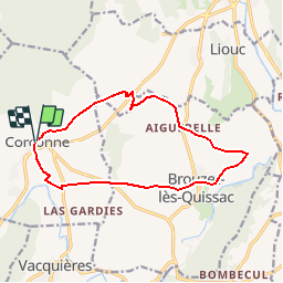
Randonnée Marche de 13,9 km à découvrir à Occitanie, Gard, Corconne. Cette randonnée est proposée par guignier.
Description
A partir du centre du village partir vers la vialatte-chemin des graves-aiguebelle-ruisseau des valadas-brouzet-moulin de vere-brestalou-corconne..voir les poteaux indicatifs
Localisation
Pays :
France
Région :
Occitanie
Département/Province :
Gard
Commune :
Corconne
Localité :
Unknown
Départ:(Dec)
Départ:(UTM)
575540 ; 4858150 (31T) N.
Commentaires
Randonnées à proximité
![Randonnée Marche Quissac - Quissac - Photo](https://media.geolcdn.com/t/375/260/ext.jpg?maxdim=2&url=https%3A%2F%2Fservices.sitytrail.com%2FGeolivesWS%2FDownloadMedia.ashx%3FTrailID%3D233243%26Media%3Dfix__20131117121007.jpg)
![Marche Marche](https://static1.geolcdn.com/sitytour/trail-icons/101.png)
![Randonnée Marche Carnas - Carnas bois de Paris - Photo](https://media.geolcdn.com/t/375/260/ext.jpg?maxdim=2&url=https%3A%2F%2Fservices.sitytrail.com%2FGeolivesWS%2FDownloadMedia.ashx%3FTrailID%3D178653%26Media%3D20130304133341.jpeg)
![Marche Marche](https://static1.geolcdn.com/sitytour/trail-icons/101.png)
Carnas bois de Paris
Marche
Moyen
(2)
Carnas,
Occitanie,
Gard,
France
![](/images/other/stat-length.png)
12,8 km | 15,6 km-effort
4h 0min
![](https://static1.geolcdn.com/siteimages/upload/files/16400158638029165_repeat_loop_refresh_sync_direction_icon.png)
Oui
![Randonnée A pied Liouc - Les chênes de Coutach - Photo](https://media.geolcdn.com/t/375/260/ext.jpg?maxdim=2&url=https%3A%2F%2Fmedia.geolcdn.com%2Ff%2Fcf45b531-3715-4133-ba5a-b053d48b9be2.jpeg)
![A pied A pied](https://static1.geolcdn.com/sitytour/trail-icons/100.png)
Les chênes de Coutach
A pied
Facile
Liouc,
Occitanie,
Gard,
France
![](/images/other/stat-length.png)
6,7 km | 10,6 km-effort
2h 24min
![](https://static1.geolcdn.com/siteimages/upload/files/16400158638029165_repeat_loop_refresh_sync_direction_icon.png)
Non
![Randonnée Marche Lauret - lac de Matane / moulin de la Fous - Photo](https://media.geolcdn.com/t/375/260/ext.jpg?maxdim=2&url=https%3A%2F%2Fmedia.geolcdn.com%2Ff%2F7a42b83d-a238-4ec2-9bf1-47f0c2f04255.jpg)
![Marche Marche](https://static1.geolcdn.com/sitytour/trail-icons/101.png)
lac de Matane / moulin de la Fous
Marche
Moyen
Lauret,
Occitanie,
Hérault,
France
![](/images/other/stat-length.png)
12,3 km | 17,7 km-effort
5h 5min
![](https://static1.geolcdn.com/siteimages/upload/files/16400158638029165_repeat_loop_refresh_sync_direction_icon.png)
Oui
![Randonnée Marche Claret - LL34 Reculée de Claret - Photo](https://media.geolcdn.com/t/375/260/ext.jpg?maxdim=2&url=https%3A%2F%2Fstatic1.geolcdn.com%2Fsiteimages%2Fupload%2Ffiles%2F1553511878bg_sport_marche.png)
![Marche Marche](https://static1.geolcdn.com/sitytour/trail-icons/101.png)
LL34 Reculée de Claret
Marche
Moyen
(2)
Claret,
Occitanie,
Hérault,
France
![](/images/other/stat-length.png)
17,1 km | 22 km-effort
5h 30min
![](https://static1.geolcdn.com/siteimages/upload/files/16400158638029165_repeat_loop_refresh_sync_direction_icon.png)
Oui
![Randonnée Marche Claret - LL34 Reculée de Claret-1 - Photo](https://media.geolcdn.com/t/375/260/ext.jpg?maxdim=2&url=https%3A%2F%2Fstatic1.geolcdn.com%2Fsiteimages%2Fupload%2Ffiles%2F1553511878bg_sport_marche.png)
![Marche Marche](https://static1.geolcdn.com/sitytour/trail-icons/101.png)
LL34 Reculée de Claret-1
Marche
Facile
(1)
Claret,
Occitanie,
Hérault,
France
![](/images/other/stat-length.png)
12,9 km | 16,6 km-effort
3h 52min
![](https://static1.geolcdn.com/siteimages/upload/files/16400158638029165_repeat_loop_refresh_sync_direction_icon.png)
Oui
![Randonnée Marche Corconne - Corconne et la forêt de Coutach - Photo](https://media.geolcdn.com/t/375/260/ext.jpg?maxdim=2&url=https%3A%2F%2Fstatic1.geolcdn.com%2Fsiteimages%2Fupload%2Ffiles%2F1553511878bg_sport_marche.png)
![Marche Marche](https://static1.geolcdn.com/sitytour/trail-icons/101.png)
Corconne et la forêt de Coutach
Marche
Facile
(2)
Corconne,
Occitanie,
Gard,
France
![](/images/other/stat-length.png)
18,1 km | 25 km-effort
5h 26min
![](https://static1.geolcdn.com/siteimages/upload/files/16400158638029165_repeat_loop_refresh_sync_direction_icon.png)
Oui
![Randonnée Marche Corconne - Corconne - Photo](https://media.geolcdn.com/t/375/260/ext.jpg?maxdim=2&url=https%3A%2F%2Fstatic1.geolcdn.com%2Fsiteimages%2Fupload%2Ffiles%2F1553511878bg_sport_marche.png)
![Marche Marche](https://static1.geolcdn.com/sitytour/trail-icons/101.png)
![Randonnée Marche Corconne - 30 le mazet des gardes Corconne 8/11/23 - Photo](https://media.geolcdn.com/t/375/260/ext.jpg?maxdim=2&url=https%3A%2F%2Fmedia.geolcdn.com%2Ff%2Fb14cbd76-fce3-469c-9994-e0217aa95e9f.jpg)
![Marche Marche](https://static1.geolcdn.com/sitytour/trail-icons/101.png)
30 le mazet des gardes Corconne 8/11/23
Marche
Très difficile
Corconne,
Occitanie,
Gard,
France
![](/images/other/stat-length.png)
18,1 km | 24 km-effort
5h 21min
![](https://static1.geolcdn.com/siteimages/upload/files/16400158638029165_repeat_loop_refresh_sync_direction_icon.png)
Oui