![](/images/other/stat-length.png)
![Randonnée Marche Modave - MODAVE - Froide Fontaine - Photo](https://media.geolcdn.com/t/1900/400/ext.pjpeg?maxdim=2&url=https%3A%2F%2Fservices.sitytrail.com%2FGeolivesWS%2FDownloadMedia.ashx%3FTrailID%3D163540%26Media%3Da9dfd4e0-07be-4695-be31-23a02d75fa1f.jpg)
MODAVE - Froide Fontaine
tourcondroz
Utilisateur
![Longueur](/images/other/stat-length.png)
Longueur
8,6 km
![Altitude max](https://static1.geolcdn.com/siteimages/upload/files/1508320355ic_sort_altitude_max_24dp.png)
Altitude max
271 m
![Dénivelé positif](https://static1.geolcdn.com/siteimages/upload/files/1508320355ic_sort_den_pos_24dp.png)
Dénivelé positif
149 m
![Km-Effort](/images/other/stat-length.png)
Km-Effort
10,6 km
![Altitude min](https://static1.geolcdn.com/siteimages/upload/files/1508320355ic_sort_altitude_min_24dp.png)
Altitude min
201 m
![Dénivelé négatif](https://static1.geolcdn.com/siteimages/upload/files/1508320355ic_sort_den_neg_24dp.png)
Dénivelé négatif
151 m
![Boucle](https://static1.geolcdn.com/siteimages/upload/files/16400158638029165_repeat_loop_refresh_sync_direction_icon.png)
Boucle
Oui
![Balise](https://services.sitytrail.com/GeolivesWS/DownloadMedia.ashx?TrailID=163540&Media=balise.png)
Balise
Date de création :
2019-04-01 13:27:43.572
Dernière modification :
2019-04-01 13:27:43.78
![Marche](https://static1.geolcdn.com/sitytour/trail-icons/101.png)
2h14
Difficulté : Moyen
![Scannez ce code QR pour ouvrir la randonnée dans l'application SityTrail](https://capi.geolives.com/qq0zvz2zws4bq2lad0pu/sitytour/trails/163540/qr.png?size=200)
Application GPS de randonnée GRATUITE
À propos
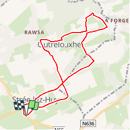
Randonnée Marche de 8,6 km à découvrir à Wallonie, Liège, Modave. Cette randonnée est proposée par tourcondroz.
Description
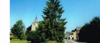
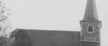
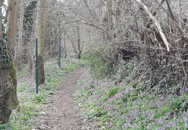
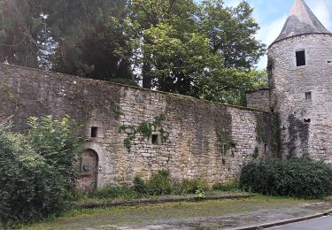
Au départ de l'église de Strée, cette promenade permet de découvrir le village de Strée et dans sa partie nord.
BALISE: losange bleu
Sources: SIVH
Crédits photographiques: SIVH
Points d'intérêt
Localisation
Pays :
Belgique
Région :
Wallonie
Département/Province :
Liège
Commune :
Modave
Localité :
Strée
Départ:(Dec)
Départ:(UTM)
664879 ; 5595540 (31U) N.
Commentaires
Randonnées à proximité
![Randonnée Marche Marchin - MARCHIN - Chemin de la Mémoire - Photo](https://media.geolcdn.com/t/375/260/ext.jpg?maxdim=2&url=https%3A%2F%2Fservices.sitytrail.com%2FGeolivesWS%2FDownloadMedia.ashx%3FTrailID%3D134945%26Media%3D9baec6a8-ffff-4223-8cd2-41c1e7b6afda.jpg)
![Marche Marche](https://static1.geolcdn.com/sitytour/trail-icons/101.png)
MARCHIN - Chemin de la Mémoire
Marche
Moyen
(5)
Marchin,
Wallonie,
Liège,
Belgique
![](/images/other/stat-length.png)
9 km | 11 km-effort
2h 15min
![](https://static1.geolcdn.com/siteimages/upload/files/16400158638029165_repeat_loop_refresh_sync_direction_icon.png)
Oui
![Randonnée Marche Modave - Rausa GR 575 bis - Photo](https://media.geolcdn.com/t/375/260/ext.jpg?maxdim=2&url=https%3A%2F%2Fstatic1.geolcdn.com%2Fsiteimages%2Fupload%2Ffiles%2F1553511878bg_sport_marche.png)
![Marche Marche](https://static1.geolcdn.com/sitytour/trail-icons/101.png)
Rausa GR 575 bis
Marche
Facile
(12)
Modave,
Wallonie,
Liège,
Belgique
![](/images/other/stat-length.png)
6 km | 7,7 km-effort
1h 38min
![](https://static1.geolcdn.com/siteimages/upload/files/16400158638029165_repeat_loop_refresh_sync_direction_icon.png)
Oui
![Randonnée Marche Nandrin - Villers le temple . st jean sart . clemaude - Photo](https://media.geolcdn.com/t/375/260/ext.jpg?maxdim=2&url=https%3A%2F%2Fmedia.geolcdn.com%2Ff%2Fc7438fda-ad3c-4a12-91ed-f3aabfc6b7ce.jpg)
![Marche Marche](https://static1.geolcdn.com/sitytour/trail-icons/101.png)
Villers le temple . st jean sart . clemaude
Marche
Très facile
(1)
Nandrin,
Wallonie,
Liège,
Belgique
![](/images/other/stat-length.png)
7,9 km | 10,4 km-effort
2h 12min
![](https://static1.geolcdn.com/siteimages/upload/files/16400158638029165_repeat_loop_refresh_sync_direction_icon.png)
Oui
![Randonnée Marche Huy - TIHANGE (Temple Tibétain). - Photo](https://media.geolcdn.com/t/375/260/ext.jpg?maxdim=2&url=https%3A%2F%2Fservices.sitytrail.com%2FGeolivesWS%2FDownloadMedia.ashx%3FTrailID%3D458488%26Media%3Dfix__20150813122829.jpg)
![Marche Marche](https://static1.geolcdn.com/sitytour/trail-icons/101.png)
TIHANGE (Temple Tibétain).
Marche
Très facile
(2)
Huy,
Wallonie,
Liège,
Belgique
![](/images/other/stat-length.png)
11,5 km | 13,9 km-effort
3h 1min
![](https://static1.geolcdn.com/siteimages/upload/files/16400158638029165_repeat_loop_refresh_sync_direction_icon.png)
Oui
![Randonnée Marche Nandrin - promenade de la rochette : villers le temple - grand fond d'oxhe - villers le temple - Photo](https://media.geolcdn.com/t/375/260/ext.jpg?maxdim=2&url=https%3A%2F%2Fmedia.geolcdn.com%2Ff%2F6a65eaf0-07ca-4e09-ab79-c1ffba2fba6b.jpg)
![Marche Marche](https://static1.geolcdn.com/sitytour/trail-icons/101.png)
promenade de la rochette : villers le temple - grand fond d'oxhe - villers le...
Marche
Moyen
Nandrin,
Wallonie,
Liège,
Belgique
![](/images/other/stat-length.png)
10 km | 13,3 km-effort
2h 47min
![](https://static1.geolcdn.com/siteimages/upload/files/16400158638029165_repeat_loop_refresh_sync_direction_icon.png)
Oui
![Randonnée Marche Modave - Stree reco 21 12 - Photo](https://media.geolcdn.com/t/375/260/ext.jpg?maxdim=2&url=https%3A%2F%2Fstatic1.geolcdn.com%2Fsiteimages%2Fupload%2Ffiles%2F1553511878bg_sport_marche.png)
![Marche Marche](https://static1.geolcdn.com/sitytour/trail-icons/101.png)
Stree reco 21 12
Marche
Moyen
(1)
Modave,
Wallonie,
Liège,
Belgique
![](/images/other/stat-length.png)
7,6 km | 9,3 km-effort
1h 55min
![](https://static1.geolcdn.com/siteimages/upload/files/16400158638029165_repeat_loop_refresh_sync_direction_icon.png)
Oui
![Randonnée Marche Marchin - Vyle et Tharoul 29-1-2023 - Photo](https://media.geolcdn.com/t/375/260/ext.jpg?maxdim=2&url=https%3A%2F%2Fstatic1.geolcdn.com%2Fsiteimages%2Fupload%2Ffiles%2F1553511878bg_sport_marche.png)
![Marche Marche](https://static1.geolcdn.com/sitytour/trail-icons/101.png)
Vyle et Tharoul 29-1-2023
Marche
Difficile
(1)
Marchin,
Wallonie,
Liège,
Belgique
![](/images/other/stat-length.png)
9,7 km | 12,3 km-effort
2h 47min
![](https://static1.geolcdn.com/siteimages/upload/files/16400158638029165_repeat_loop_refresh_sync_direction_icon.png)
Oui
![Randonnée Marche Huy - Bois de Tihange - Photo](https://media.geolcdn.com/t/375/260/ext.jpg?maxdim=2&url=https%3A%2F%2Fstatic1.geolcdn.com%2Fsiteimages%2Fupload%2Ffiles%2F1553511878bg_sport_marche.png)
![Marche Marche](https://static1.geolcdn.com/sitytour/trail-icons/101.png)
Bois de Tihange
Marche
Moyen
(2)
Huy,
Wallonie,
Liège,
Belgique
![](/images/other/stat-length.png)
8,4 km | 10,4 km-effort
2h 14min
![](https://static1.geolcdn.com/siteimages/upload/files/16400158638029165_repeat_loop_refresh_sync_direction_icon.png)
Oui
![Randonnée Marche Modave - regissa marchin - Photo](https://media.geolcdn.com/t/375/260/ext.jpg?maxdim=2&url=https%3A%2F%2Fstatic1.geolcdn.com%2Fsiteimages%2Fupload%2Ffiles%2F1553511878bg_sport_marche.png)
![Marche Marche](https://static1.geolcdn.com/sitytour/trail-icons/101.png)
regissa marchin
Marche
Moyen
(2)
Modave,
Wallonie,
Liège,
Belgique
![](/images/other/stat-length.png)
9,9 km | 13,1 km-effort
2h 44min
![](https://static1.geolcdn.com/siteimages/upload/files/16400158638029165_repeat_loop_refresh_sync_direction_icon.png)
Oui