


o2bikers_120_Tessenderlo

O2 bikers
Randonnées de O2bikers GUIDE+
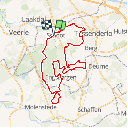

Longueur
67 km

Altitude max
58 m

Dénivelé positif
727 m
Km-Effort
76 km

Altitude min
16 m

Dénivelé négatif
727 m
Boucle
Oui
Date de création :
2014-12-11 00:00:00.0
Dernière modification :
2014-12-11 00:00:00.0
--
Difficulté : Inconnu

Application GPS de randonnée GRATUITE
 SityTrail
IGN / Instituts géographiques
SityTrail Plus
Le monde est à vous
À propos
Randonnée V.T.T. de 67 km à découvrir à Flandre, Limbourg, Tessenderlo. Cette randonnée est proposée par O2 bikers.
Localisation
Pays :
Belgique
Région :
Flandre
Département/Province :
Limbourg
Commune :
Tessenderlo
Localité :
Tessenderlo
Départ:(Dec)
Départ:(UTM)
642560 ; 5659100 (31U) N.
Commentaires