Randonnée Autre activité Neuchâtel - Neuchâtelareuse - Photo
 mab
mab

Utilisateur

© OpenStreetMap contributors
Longueur
Longueur
12,1 km
Altitude max
Altitude max
480 m
Dénivelé positif
Dénivelé positif
92 m
Km-Effort
Km-Effort  
13,4 km
Altitude min
Altitude min
422 m
Dénivelé négatif
Dénivelé négatif
127 m
Boucle
Boucle
Non
Date de création :
2014-12-11 00:00:00.0
Dernière modification :
2014-12-11 00:00:00.0

(0 Avis)

Autre activité
Autre activité
--
Difficulté : Inconnu

Scannez ce code QR pour ouvrir la randonnée dans l'application SityTrail

Application GPS de randonnée GRATUITE

Logo SityTrail SityTrail

IGN / Instituts géographiques

Télécharger SityTrail sur l'App Store Télécharger SityTrail sur Google Play

Logo SityTrail SityTrail World

Le monde est à vous

Télécharger SityTrail sur l'App Store Télécharger SityTrail sur Google Play Télécharger SityTrail sur Huawei AppGallery

À propos

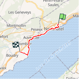
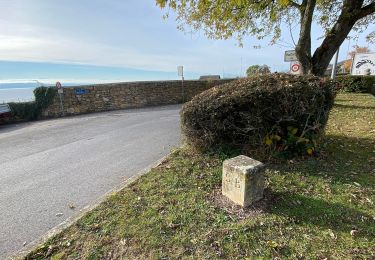
Randonnée Autre activité de 12,1 km à découvrir à Neuchâtel, Inconnu, Neuchâtel. Cette randonnée est proposée par mab.

Description

Les barzettes Trubelnstock retour

Profil altimétrique

Localisation

Pays :
Suisse
Région :
Neuchâtel
Département/Province :
Inconnu
Commune :
Neuchâtel
Localité :
Unknown
Départ:(Dec)
Départ:(UTM)
343321 ; 5206890 (32T) N.

Randonnées à proximité

Randonnée A pied Neuchâtel - Valangin - Serroue - Photo
A pied
PRO

A pied

Facile
Neuchâtel, Neuchâtel, Inconnu, Suisse
3,1 km | 4,7 km-effort
1h 4min
Non
Randonnée A pied Neuchâtel - Chaumont Funiculaire - Les Trois Bornes - Photo
A pied
PRO

A pied

Facile
Neuchâtel, Neuchâtel, Inconnu, Suisse
4,2 km | 5,4 km-effort
1h 14min
Non
Randonnée A pied Neuchâtel - Neuchâtel Cadolles - Ch. de la Châtelainie - Photo
A pied
PRO

A pied

Facile
Neuchâtel, Neuchâtel, Inconnu, Suisse
4,8 km | 6,3 km-effort
1h 25min
Non
Randonnée A pied Neuchâtel - Enges - Chemin de la Châtelainie - Photo
A pied
PRO

A pied

Facile
Neuchâtel, Neuchâtel, Inconnu, Suisse
6,6 km | 9,5 km-effort
2h 9min
Non
Randonnée V.T.T. Neuchâtel - Bike32913 - Photo
V.T.T.
GUIDE+

V.T.T.

Très facile
Neuchâtel, Neuchâtel, Inconnu, Suisse
37 km | 55 km-effort
Inconnu
Oui
Randonnée Marche Neuchâtel - bike_creuxduvan - Photo
Marche
GUIDE+

Marche

Très facile
Neuchâtel, Neuchâtel, Inconnu, Suisse
55 km | 80 km-effort
15h 30min
Oui
Randonnée Autre activité Hauterive (NE) - Lac de Morat - Photo
Autre activité
Werner44

Autre activité

Très facile
Hauterive (NE), Neuchâtel, Inconnu, Suisse
61 km | 68 km-effort
Inconnu
Oui
Randonnée Via ferrata Hauterive (NE) - Lac de Bienne - Photo
Via ferrata
Werner44

Via ferrata

Très facile
Hauterive (NE), Neuchâtel, Inconnu, Suisse
61 km | 68 km-effort
Inconnu
Oui
Randonnée Autre activité Hauterive (NE) - Hauterive-Landeron - Photo
Autre activité
Werner44

Autre activité

Très facile
Hauterive (NE), Neuchâtel, Inconnu, Suisse
10,5 km | 15,4 km-effort
Inconnu
Non


Fermer
Mes abonnements