![](/images/other/stat-length.png)
![Randonnée Marche Vireux-Molhain - Balade Franco-Belge - De Vireux-Molhain à Mazée - Photo](https://media.geolcdn.com/t/1900/400/ext.pjpeg?maxdim=2&url=https%3A%2F%2Fservices.sitytrail.com%2FGeolivesWS%2FDownloadMedia.ashx%3FTrailID%3D191490%26Media%3D15083_5.jpg)
Balade Franco-Belge - De Vireux-Molhain à Mazée
tracegps
Utilisateur
![Longueur](/images/other/stat-length.png)
Longueur
14,4 km
![Altitude max](https://static1.geolcdn.com/siteimages/upload/files/1508320355ic_sort_altitude_max_24dp.png)
Altitude max
242 m
![Dénivelé positif](https://static1.geolcdn.com/siteimages/upload/files/1508320355ic_sort_den_pos_24dp.png)
Dénivelé positif
362 m
![Km-Effort](/images/other/stat-length.png)
Km-Effort
19,2 km
![Altitude min](https://static1.geolcdn.com/siteimages/upload/files/1508320355ic_sort_altitude_min_24dp.png)
Altitude min
110 m
![Dénivelé négatif](https://static1.geolcdn.com/siteimages/upload/files/1508320355ic_sort_den_neg_24dp.png)
Dénivelé négatif
361 m
![Boucle](https://static1.geolcdn.com/siteimages/upload/files/16400158638029165_repeat_loop_refresh_sync_direction_icon.png)
Boucle
Oui
Date de création :
2014-12-10 00:00:00.0
Dernière modification :
2014-12-10 00:00:00.0
![Marche](https://static1.geolcdn.com/sitytour/trail-icons/101.png)
3h30
Difficulté : Moyen
![Scannez ce code QR pour ouvrir la randonnée dans l'application SityTrail](https://capi.geolives.com/qq0zvz2zws4bq2lad0pu/sitytour/trails/191490/qr.png?size=200)
Application GPS de randonnée GRATUITE
À propos
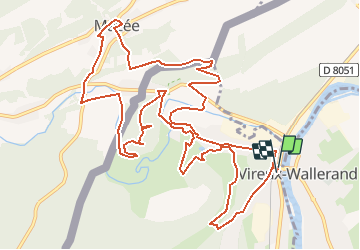
Randonnée Marche de 14,4 km à découvrir à Grand Est, Ardennes, Vireux-Molhain. Cette randonnée est proposée par tracegps.
Description
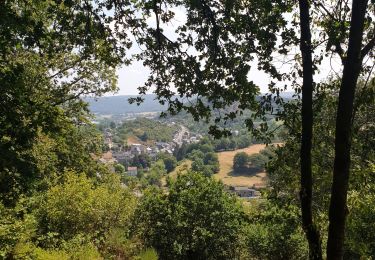
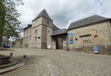
Par monts et vallées, la randonnée rencontre des points de vue exceptionnels sur la vallée du Viroin, la grande forêt des Ardennes Franco-Belges, la forêt de Thiérache et le site fortifié du Mont-Vireux. Départ: Eglise de Vireux-Molhain.
Points d'intérêt
Localisation
Pays :
France
Région :
Grand Est
Département/Province :
Ardennes
Commune :
Vireux-Molhain
Localité :
Unknown
Départ:(Dec)
Départ:(UTM)
623371 ; 5549533 (31U) N.
Commentaires
Randonnées à proximité
![Randonnée Marche Viroinval - RB-Na-12_Treignes_via-racc - Photo](https://media.geolcdn.com/t/375/260/ext.jpg?maxdim=2&url=https%3A%2F%2Fservices.sitytrail.com%2FGeolivesWS%2FDownloadMedia.ashx%3FTrailID%3D794212%26Media%3D5fba0928-65b8-4f08-8244-3dd1e2295f4a.jpg)
![Marche Marche](https://static1.geolcdn.com/sitytour/trail-icons/101.png)
RB-Na-12_Treignes_via-racc
Marche
Moyen
(2)
Viroinval,
Wallonie,
Namur,
Belgique
![](/images/other/stat-length.png)
14,8 km | 21 km-effort
6h 13min
![](https://static1.geolcdn.com/siteimages/upload/files/16400158638029165_repeat_loop_refresh_sync_direction_icon.png)
Oui
![Randonnée Marche Viroinval - Mazée, sur le sentier des Douaniers - Photo](https://media.geolcdn.com/t/375/260/ext.jpg?maxdim=2&url=https%3A%2F%2Fmedia.geolcdn.com%2Ff%2Fe6a3fc86-55fd-4ddf-a6e6-df3228867288.jpg)
![Marche Marche](https://static1.geolcdn.com/sitytour/trail-icons/101.png)
Mazée, sur le sentier des Douaniers
Marche
Très facile
(1)
Viroinval,
Wallonie,
Namur,
Belgique
![](/images/other/stat-length.png)
7,6 km | 10,5 km-effort
4h 2min
![](https://static1.geolcdn.com/siteimages/upload/files/16400158638029165_repeat_loop_refresh_sync_direction_icon.png)
Oui
![Randonnée Marche Vireux-Molhain - Du Mont Vireux au château de Hierges - Photo](https://media.geolcdn.com/t/375/260/ext.jpg?maxdim=2&url=https%3A%2F%2Fservices.sitytrail.com%2FGeolivesWS%2FDownloadMedia.ashx%3FTrailID%3D108904%26Media%3D2563_6.jpg)
![Marche Marche](https://static1.geolcdn.com/sitytour/trail-icons/101.png)
Du Mont Vireux au château de Hierges
Marche
Difficile
(1)
Vireux-Molhain,
Grand Est,
Ardennes,
France
![](/images/other/stat-length.png)
12,3 km | 16,8 km-effort
4h 0min
![](https://static1.geolcdn.com/siteimages/upload/files/16400158638029165_repeat_loop_refresh_sync_direction_icon.png)
Oui
![Randonnée Marche Vireux-Molhain - Du Mont Vireux au château de Hierges - Photo](https://media.geolcdn.com/t/375/260/ext.jpg?maxdim=2&url=https%3A%2F%2Fstatic1.geolcdn.com%2Fsiteimages%2Fupload%2Ffiles%2F1553511878bg_sport_marche.png)
![Marche Marche](https://static1.geolcdn.com/sitytour/trail-icons/101.png)
Du Mont Vireux au château de Hierges
Marche
Facile
(1)
Vireux-Molhain,
Grand Est,
Ardennes,
France
![](/images/other/stat-length.png)
12,3 km | 16,8 km-effort
3h 0min
![](https://static1.geolcdn.com/siteimages/upload/files/16400158638029165_repeat_loop_refresh_sync_direction_icon.png)
Oui
![Randonnée Marche Doische - De Vaucelles à Hierges par la montagne de le carrière - Photo](https://media.geolcdn.com/t/375/260/ext.jpg?maxdim=2&url=https%3A%2F%2Fmedia.geolcdn.com%2Ff%2Fff0fe14c-ce13-470d-811d-574f23709db3.JPG)
![Marche Marche](https://static1.geolcdn.com/sitytour/trail-icons/101.png)
De Vaucelles à Hierges par la montagne de le carrière
Marche
Moyen
(1)
Doische,
Wallonie,
Namur,
Belgique
![](/images/other/stat-length.png)
6,7 km | 8,7 km-effort
1h 58min
![](https://static1.geolcdn.com/siteimages/upload/files/16400158638029165_repeat_loop_refresh_sync_direction_icon.png)
Oui
![Randonnée A pied Viroinval - La Villa Gallo-Romaine - Photo](https://media.geolcdn.com/t/375/260/ext.jpg?maxdim=2&url=https%3A%2F%2Fmedia.geolcdn.com%2Ff%2F0fbc23cb-6394-4025-9f50-97c9c9ed0621.jpeg)
![A pied A pied](https://static1.geolcdn.com/sitytour/trail-icons/100.png)
La Villa Gallo-Romaine
A pied
Facile
Viroinval,
Wallonie,
Namur,
Belgique
![](/images/other/stat-length.png)
3,7 km | 4,5 km-effort
1h 1min
![](https://static1.geolcdn.com/siteimages/upload/files/16400158638029165_repeat_loop_refresh_sync_direction_icon.png)
Oui
![Randonnée A pied Viroinval - Pré Aigret - Photo](https://media.geolcdn.com/t/375/260/ext.jpg?maxdim=2&url=https%3A%2F%2Fmedia.geolcdn.com%2Ff%2F0fbc23cb-6394-4025-9f50-97c9c9ed0621.jpeg)
![A pied A pied](https://static1.geolcdn.com/sitytour/trail-icons/100.png)
![Randonnée A pied Viroinval - Les Rivelottes - Photo](https://media.geolcdn.com/t/375/260/ext.jpg?maxdim=2&url=https%3A%2F%2Fmedia.geolcdn.com%2Ff%2F0fbc23cb-6394-4025-9f50-97c9c9ed0621.jpeg)
![A pied A pied](https://static1.geolcdn.com/sitytour/trail-icons/100.png)
Les Rivelottes
A pied
Facile
Viroinval,
Wallonie,
Namur,
Belgique
![](/images/other/stat-length.png)
3,6 km | 4,8 km-effort
1h 5min
![](https://static1.geolcdn.com/siteimages/upload/files/16400158638029165_repeat_loop_refresh_sync_direction_icon.png)
Oui
![Randonnée A pied Viroinval - Les Elmonts - Photo](https://media.geolcdn.com/t/375/260/ext.jpg?maxdim=2&url=https%3A%2F%2Fmedia.geolcdn.com%2Ff%2F0fbc23cb-6394-4025-9f50-97c9c9ed0621.jpeg)
![A pied A pied](https://static1.geolcdn.com/sitytour/trail-icons/100.png)