Randonnée Vélo Cornol - 0110  3  Cornol - St.Ursanne - Photo

0110 3 Cornol - St.Ursanne

 LCGsell
LCGsell

Utilisateur

© OpenStreetMap contributors
Longueur
Longueur
10,6 km
Altitude max
Altitude max
786 m
Dénivelé positif
Dénivelé positif
333 m
Km-Effort
Km-Effort  
15,3 km
Altitude min
Altitude min
437 m
Dénivelé négatif
Dénivelé négatif
409 m
Boucle
Boucle
Non
Date de création :
2014-12-11 00:00:00.0
Dernière modification :
2014-12-11 00:00:00.0

(0 Avis)

Vélo
Vélo
--
Difficulté : Inconnu

Scannez ce code QR pour ouvrir la randonnée dans l'application SityTrail

Application GPS de randonnée GRATUITE

Logo SityTrail SityTrail

IGN / Instituts géographiques

Télécharger SityTrail sur l'App Store Télécharger SityTrail sur Google Play

Logo SityTrail SityTrail World

Le monde est à vous

Télécharger SityTrail sur l'App Store Télécharger SityTrail sur Google Play Télécharger SityTrail sur Huawei AppGallery

À propos

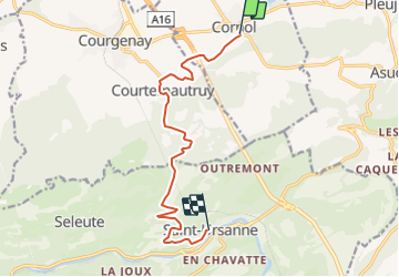
Randonnée Vélo de 10,6 km à découvrir à Jura, District de Porrentruy, Cornol. Cette randonnée est proposée par LCGsell.

Description

In Cornol folgt man den Wegweisern der Route Nr. 7, die auf der Nordseite des Mont Terri auf Feldwegen an einem Bauernhof mit Kapelle vorbei führt und nachdem man die Tunneleinfahrt der Autobahn passiert hat erreicht man Courtemautruy. Nun geht es auf der NR. 7 steil hinauf in den Jura zum Col de la Croix. Hier oben verlässt man die offizielle Velo Route Nr. 7, die rechts abbiegt und erfreut sich auf dem festen Belag an der Talfahrt nach St.Ursanne hinunter.

In Cornol you follow the signs of the National Bike Route Nr. 7 along the north side of Mount Terri leading you on farmers roads to a farm house with a nearby chappel and across the highway disappearing in its tunnel. In Courtemautruy  we are back on normal roads and still on Bike Route 7 climb the steep Col de la Croix. The official bike route turns right on gravel again. We stay on the better main road for an enjoyable downhill to St.Ursanne.

Profil altimétrique

Localisation

Pays :
Suisse
Région :
Jura
Département/Province :
District de Porrentruy
Commune :
Cornol
Localité :
Unknown
Départ:(Dec)
Départ:(UTM)
361407 ; 5251909 (32T) N.

Randonnées à proximité

Randonnée Marche Levoncourt - Sortie les Copains d'abord.. 24/03/2022 - Photo
Marche
boubou68

Marche

Moyen
Levoncourt, Grand Est, Haut-Rhin, France
24 km | 34 km-effort
4h 57min
Oui
Randonnée A pied Clos du Doubs - Col de la Croix - Seleute - Photo
A pied
PRO

A pied

Facile
Clos du Doubs, Jura, District de Porrentruy, Suisse
4,3 km | 6,3 km-effort
1h 26min
Non
Randonnée A pied La Baroche - Pleujuse - fixme - Photo
A pied
PRO

A pied

Facile
La Baroche, Jura, District de Porrentruy, Suisse
3,1 km | 5,6 km-effort
1h 16min
Non
Randonnée Vélo Clos du Doubs - St.Ursanne - Basel (Jura Suisse) - Photo
Vélo
karawatsj

Vélo

Difficile
Clos du Doubs, Jura, District de Porrentruy, Suisse
68 km | 88 km-effort
5h 45min
Non
Randonnée Marche La Baroche - Les Rangiers - Photo
Marche
tiene

Marche

Moyen
La Baroche, Jura, District de Porrentruy, Suisse
19,9 km | 30 km-effort
6h 28min
Oui
Randonnée V.T.T. Clos du Doubs - Bike32908 - Photo
V.T.T.
GUIDE+

V.T.T.

Très facile
Clos du Doubs, Jura, District de Porrentruy, Suisse
34 km | 46 km-effort
Inconnu
Oui
Randonnée Autre activité La Baroche - Les vergers de La Baroche - Photo
Autre activité
necira

Autre activité

Très facile
La Baroche, Jura, District de Porrentruy, Suisse
12,8 km | 15,9 km-effort
Inconnu
Oui
Randonnée Autre activité Clos du Doubs - St. Ursanne - Le Noirmont - Photo
Autre activité
bffcuc

Autre activité

Très facile
Clos du Doubs, Jura, District de Porrentruy, Suisse
37 km | 53 km-effort
Inconnu
Non
Randonnée Vélo Clos du Doubs - 0110 4  St.Ursanne - Saignelégier - Photo
Vélo
LCGsell

Vélo

Très facile
Clos du Doubs, Jura, District de Porrentruy, Suisse
24 km | 32 km-effort
Inconnu
Non


Fermer
Mes abonnements