![](/images/other/stat-length.png)
![Randonnée V.T.C. Wanze - Wanse Fallais Waleffes vinalmont - Photo](https://media.geolcdn.com/t/1900/400/ext.pjpeg?maxdim=2&url=https%3A%2F%2Fstatic1.geolcdn.com%2Fsiteimages%2Fupload%2Ffiles%2F1524743154velo.jpg)
Wanse Fallais Waleffes vinalmont
Lucdelmoitie
Utilisateur
![Longueur](/images/other/stat-length.png)
Longueur
29 km
![Altitude max](https://static1.geolcdn.com/siteimages/upload/files/1508320355ic_sort_altitude_max_24dp.png)
Altitude max
202 m
![Dénivelé positif](https://static1.geolcdn.com/siteimages/upload/files/1508320355ic_sort_den_pos_24dp.png)
Dénivelé positif
375 m
![Km-Effort](/images/other/stat-length.png)
Km-Effort
34 km
![Altitude min](https://static1.geolcdn.com/siteimages/upload/files/1508320355ic_sort_altitude_min_24dp.png)
Altitude min
71 m
![Dénivelé négatif](https://static1.geolcdn.com/siteimages/upload/files/1508320355ic_sort_den_neg_24dp.png)
Dénivelé négatif
403 m
![Boucle](https://static1.geolcdn.com/siteimages/upload/files/16400158638029165_repeat_loop_refresh_sync_direction_icon.png)
Boucle
Non
Date de création :
2019-06-02 13:54:57.227
Dernière modification :
2019-06-03 07:49:36.892
![V.T.C.](https://static1.geolcdn.com/sitytour/trail-icons/203.png)
2h00
Difficulté : Moyen
![Cyclotourisme](https://static1.geolcdn.com/sitytour/trail-icons/204.png)
2h10
Difficulté : Moyen
![Vélo électrique](https://static1.geolcdn.com/sitytour/trail-icons/205.png)
2h01
Difficulté : Moyen
![Scannez ce code QR pour ouvrir la randonnée dans l'application SityTrail](https://capi.geolives.com/qq0zvz2zws4bq2lad0pu/sitytour/trails/2102585/qr.png?size=200)
Application GPS de randonnée GRATUITE
À propos
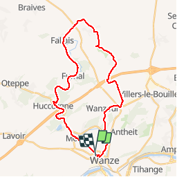
Randonnée V.T.C. de 29 km à découvrir à Wallonie, Liège, Wanze. Cette randonnée est proposée par Lucdelmoitie.
Description
Un très beau tour autour de la Mehaigne.
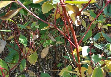
Petit tronçon sur terre et graviers qui n'est boueux que par très grosses pluies ( ce tronçon peut être évité par la route )
Localisation
Pays :
Belgique
Région :
Wallonie
Département/Province :
Liège
Commune :
Wanze
Localité :
Wanze
Départ:(Dec)
Départ:(UTM)
656341 ; 5600817 (31U) N.
Commentaires
Randonnées à proximité
![Randonnée Marche Huy - Huy Ben-Ahin. Natura 2000 des sites qui valent le détour ! Lg9 - Photo](https://media.geolcdn.com/t/375/260/ext.jpg?maxdim=2&url=https%3A%2F%2Fservices.sitytrail.com%2FGeolivesWS%2FDownloadMedia.ashx%3FTrailID%3D182987%26Media%3Da8459ff4-9180-431b-88aa-1e326f78de1f.JPG)
![Marche Marche](https://static1.geolcdn.com/sitytour/trail-icons/101.png)
Huy Ben-Ahin. Natura 2000 des sites qui valent le détour ! Lg9
Marche
Moyen
(15)
Huy,
Wallonie,
Liège,
Belgique
![](/images/other/stat-length.png)
7,9 km | 10,7 km-effort
2h 18min
![](https://static1.geolcdn.com/siteimages/upload/files/16400158638029165_repeat_loop_refresh_sync_direction_icon.png)
Non
![Randonnée Marche Wanze - Huccorgne Hesbaye Promenade-des-Chevreuils Haspengouw - 9 km RT - Photo](https://media.geolcdn.com/t/375/260/ext.jpg?maxdim=2&url=https%3A%2F%2Fstatic1.geolcdn.com%2Fsiteimages%2Fupload%2Ffiles%2F1553511878bg_sport_marche.png)
![Marche Marche](https://static1.geolcdn.com/sitytour/trail-icons/101.png)
Huccorgne Hesbaye Promenade-des-Chevreuils Haspengouw - 9 km RT
Marche
Très facile
(5)
Wanze,
Wallonie,
Liège,
Belgique
![](/images/other/stat-length.png)
9,3 km | 11,9 km-effort
Inconnu
![](https://static1.geolcdn.com/siteimages/upload/files/16400158638029165_repeat_loop_refresh_sync_direction_icon.png)
Oui
![Randonnée Marche Héron - Promenade des châteaux (Couthuin) - Photo](https://media.geolcdn.com/t/375/260/ext.jpg?maxdim=2&url=https%3A%2F%2Fmedia.geolcdn.com%2Ff%2Fd580117c-a9d5-4ac9-a44f-0f59b38e05c1.jpg)
![Marche Marche](https://static1.geolcdn.com/sitytour/trail-icons/101.png)
Promenade des châteaux (Couthuin)
Marche
Moyen
(1)
Héron,
Wallonie,
Liège,
Belgique
![](/images/other/stat-length.png)
9,1 km | 10,7 km-effort
2h 25min
![](https://static1.geolcdn.com/siteimages/upload/files/16400158638029165_repeat_loop_refresh_sync_direction_icon.png)
Oui
![Randonnée Marche Wanze - CHATEAU DE MOHA - Photo](https://media.geolcdn.com/t/375/260/ext.jpg?maxdim=2&url=https%3A%2F%2Fmedia.geolcdn.com%2Ff%2F20215672-f7b5-46c5-95ea-ea116dfd066e.JPEG)
![Marche Marche](https://static1.geolcdn.com/sitytour/trail-icons/101.png)
CHATEAU DE MOHA
Marche
Moyen
(2)
Wanze,
Wallonie,
Liège,
Belgique
![](/images/other/stat-length.png)
7,3 km | 9,1 km-effort
1h 58min
![](https://static1.geolcdn.com/siteimages/upload/files/16400158638029165_repeat_loop_refresh_sync_direction_icon.png)
Oui
![Randonnée Marche Huy - TIHANGE (Temple Tibétain). - Photo](https://media.geolcdn.com/t/375/260/ext.jpg?maxdim=2&url=https%3A%2F%2Fservices.sitytrail.com%2FGeolivesWS%2FDownloadMedia.ashx%3FTrailID%3D458488%26Media%3Dfix__20150813122829.jpg)
![Marche Marche](https://static1.geolcdn.com/sitytour/trail-icons/101.png)
TIHANGE (Temple Tibétain).
Marche
Très facile
(2)
Huy,
Wallonie,
Liège,
Belgique
![](/images/other/stat-length.png)
11,5 km | 13,9 km-effort
3h 1min
![](https://static1.geolcdn.com/siteimages/upload/files/16400158638029165_repeat_loop_refresh_sync_direction_icon.png)
Oui
![Randonnée Marche Wanze - antheit - Photo](https://media.geolcdn.com/t/375/260/ext.jpg?maxdim=2&url=https%3A%2F%2Fmedia.geolcdn.com%2Ff%2F63403872-a8da-4090-b10f-81e240d58ff7.jpg)
![Marche Marche](https://static1.geolcdn.com/sitytour/trail-icons/101.png)
![Randonnée Marche Wanze - les long pieds anthey - Photo](https://media.geolcdn.com/t/375/260/ext.jpg?maxdim=2&url=https%3A%2F%2Fmedia.geolcdn.com%2Ff%2F04ed0be7-9f2b-4519-ab41-baa0902f0e32.jpg)
![Marche Marche](https://static1.geolcdn.com/sitytour/trail-icons/101.png)
les long pieds anthey
Marche
Moyen
(1)
Wanze,
Wallonie,
Liège,
Belgique
![](/images/other/stat-length.png)
12,9 km | 16 km-effort
2h 34min
![](https://static1.geolcdn.com/siteimages/upload/files/16400158638029165_repeat_loop_refresh_sync_direction_icon.png)
Oui
![Randonnée Marche Héron - champis-couthuin - Photo](https://media.geolcdn.com/t/375/260/ext.jpg?maxdim=2&url=https%3A%2F%2Fservices.sitytrail.com%2FGeolivesWS%2FDownloadMedia.ashx%3FTrailID%3D487688%26Media%3Dfix__20151031115446.jpg)
![Marche Marche](https://static1.geolcdn.com/sitytour/trail-icons/101.png)
champis-couthuin
Marche
Très facile
(2)
Héron,
Wallonie,
Liège,
Belgique
![](/images/other/stat-length.png)
4,4 km | 5,3 km-effort
2h 25min
![](https://static1.geolcdn.com/siteimages/upload/files/16400158638029165_repeat_loop_refresh_sync_direction_icon.png)
Oui
![Randonnée Marche Huy - Ben Ahin La Solière - Photo](https://media.geolcdn.com/t/375/260/ext.jpg?maxdim=2&url=https%3A%2F%2Fservices.sitytrail.com%2FGeolivesWS%2FDownloadMedia.ashx%3FTrailID%3D42709%26Media%3Dl)
![Marche Marche](https://static1.geolcdn.com/sitytour/trail-icons/101.png)
Ben Ahin La Solière
Marche
Très facile
(1)
Huy,
Wallonie,
Liège,
Belgique
![](/images/other/stat-length.png)
14,3 km | 19 km-effort
4h 54min
![](https://static1.geolcdn.com/siteimages/upload/files/16400158638029165_repeat_loop_refresh_sync_direction_icon.png)
Oui