![](/images/other/stat-length.png)
Sentiers d'Art : Boucle16 - Somal
Vallées des Saveurs - Maison du Tourisme Condroz-Famenne
Destination Condroz-Famenne- une nature préservée PRO
![Longueur](/images/other/stat-length.png)
Longueur
7,4 km
![Altitude max](https://static1.geolcdn.com/siteimages/upload/files/1508320355ic_sort_altitude_max_24dp.png)
Altitude max
306 m
![Dénivelé positif](https://static1.geolcdn.com/siteimages/upload/files/1508320355ic_sort_den_pos_24dp.png)
Dénivelé positif
186 m
![Km-Effort](/images/other/stat-length.png)
Km-Effort
9,9 km
![Altitude min](https://static1.geolcdn.com/siteimages/upload/files/1508320355ic_sort_altitude_min_24dp.png)
Altitude min
227 m
![Dénivelé négatif](https://static1.geolcdn.com/siteimages/upload/files/1508320355ic_sort_den_neg_24dp.png)
Dénivelé négatif
183 m
![Boucle](https://static1.geolcdn.com/siteimages/upload/files/16400158638029165_repeat_loop_refresh_sync_direction_icon.png)
Boucle
Oui
Date de création :
2019-07-18 10:05:39.803
Dernière modification :
2022-10-14 08:12:13.058
![Marche](https://static1.geolcdn.com/sitytour/trail-icons/101.png)
2h07
Difficulté : Moyen
![Scannez ce code QR pour ouvrir la randonnée dans l'application SityTrail](https://capi.geolives.com/qq0zvz2zws4bq2lad0pu/sitytour/trails/2143618/qr.png?size=200)
Application GPS de randonnée GRATUITE
À propos
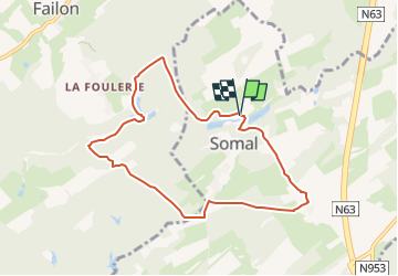
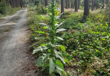
Randonnée Marche de 7,4 km à découvrir à Wallonie, Namur, Somme-Leuze. Cette randonnée est proposée par Vallées des Saveurs - Maison du Tourisme Condroz-Famenne.
Description
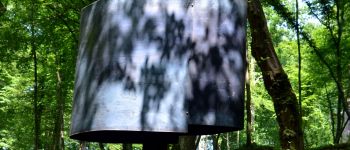
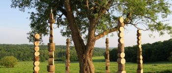
Boucle Sentiers d'Art de 7,5km qui vous fera découvrir 2 oeuvres.
Localisation
Pays :
Belgique
Région :
Wallonie
Département/Province :
Namur
Commune :
Somme-Leuze
Localité :
Unknown
Départ:(Dec)
Départ:(UTM)
665165 ; 5577886 (31U) N.
Commentaires
Randonnées à proximité
![Randonnée Marche Somme-Leuze - RB-Na-04_Nettinne - Photo](https://media.geolcdn.com/t/375/260/ext.jpg?maxdim=2&url=https%3A%2F%2Fservices.sitytrail.com%2FGeolivesWS%2FDownloadMedia.ashx%3FTrailID%3D179630%26Media%3D2ccb572a-0d57-4973-8026-20e9cbf116e6.jpg)
![Marche Marche](https://static1.geolcdn.com/sitytour/trail-icons/101.png)
RB-Na-04_Nettinne
Marche
Moyen
(14)
Somme-Leuze,
Wallonie,
Namur,
Belgique
![](/images/other/stat-length.png)
22 km | 28 km-effort
6h 0min
![](https://static1.geolcdn.com/siteimages/upload/files/16400158638029165_repeat_loop_refresh_sync_direction_icon.png)
Oui
![Randonnée Marche Somme-Leuze - RB-Na-04_Nettinne_via-racc - Photo](https://media.geolcdn.com/t/375/260/ext.jpg?maxdim=2&url=https%3A%2F%2Fservices.sitytrail.com%2FGeolivesWS%2FDownloadMedia.ashx%3FTrailID%3D252171%26Media%3Dc5d56e41-95c8-4990-91cc-1ec916893014.jpg)
![Marche Marche](https://static1.geolcdn.com/sitytour/trail-icons/101.png)
RB-Na-04_Nettinne_via-racc
Marche
Facile
(6)
Somme-Leuze,
Wallonie,
Namur,
Belgique
![](/images/other/stat-length.png)
18,7 km | 24 km-effort
5h 3min
![](https://static1.geolcdn.com/siteimages/upload/files/16400158638029165_repeat_loop_refresh_sync_direction_icon.png)
Oui
![Randonnée Marche Havelange - HAVELANGE- Failon- Promenade du Chêne au Gibet - Photo](https://media.geolcdn.com/t/375/260/ext.jpg?maxdim=2&url=https%3A%2F%2Fservices.sitytrail.com%2FGeolivesWS%2FDownloadMedia.ashx%3FTrailID%3D250680%26Media%3D5b284e0f-4186-471a-9bbe-220cdacf1b74.jpg)
![Marche Marche](https://static1.geolcdn.com/sitytour/trail-icons/101.png)
HAVELANGE- Failon- Promenade du Chêne au Gibet
Marche
Très facile
(5)
Havelange,
Wallonie,
Namur,
Belgique
![](/images/other/stat-length.png)
15,8 km | 20 km-effort
4h 17min
![](https://static1.geolcdn.com/siteimages/upload/files/16400158638029165_repeat_loop_refresh_sync_direction_icon.png)
Oui
![Randonnée Marche Havelange - FAILON (Château-Ferme de Somal) - Photo](https://media.geolcdn.com/t/375/260/ext.jpg?maxdim=2&url=https%3A%2F%2Fservices.sitytrail.com%2FGeolivesWS%2FDownloadMedia.ashx%3FTrailID%3D1004822%26Media%3Dfix__20180712160140.jpg)
![Marche Marche](https://static1.geolcdn.com/sitytour/trail-icons/101.png)
FAILON (Château-Ferme de Somal)
Marche
Facile
(3)
Havelange,
Wallonie,
Namur,
Belgique
![](/images/other/stat-length.png)
10,7 km | 14,2 km-effort
3h 1min
![](https://static1.geolcdn.com/siteimages/upload/files/16400158638029165_repeat_loop_refresh_sync_direction_icon.png)
Oui
![Randonnée A pied Somme-Leuze - La Plaine sapin - Photo](https://media.geolcdn.com/t/375/260/ext.jpg?maxdim=2&url=https%3A%2F%2Fmedia.geolcdn.com%2Ff%2F95efbe28-58df-48b0-8de7-1bc01a82e926.jpg)
![A pied A pied](https://static1.geolcdn.com/sitytour/trail-icons/100.png)
La Plaine sapin
A pied
Facile
(1)
Somme-Leuze,
Wallonie,
Namur,
Belgique
![](/images/other/stat-length.png)
5,9 km | 7,2 km-effort
1h 21min
![](https://static1.geolcdn.com/siteimages/upload/files/16400158638029165_repeat_loop_refresh_sync_direction_icon.png)
Oui
![Randonnée Marche Havelange - Bois, Rivière et champs - Photo](https://media.geolcdn.com/t/375/260/ext.jpg?maxdim=2&url=https%3A%2F%2Fmedia.geolcdn.com%2Ff%2F71798de8-0a71-47ba-81bf-636f8514053b.jpg)
![Marche Marche](https://static1.geolcdn.com/sitytour/trail-icons/101.png)
Bois, Rivière et champs
Marche
Moyen
(3)
Havelange,
Wallonie,
Namur,
Belgique
![](/images/other/stat-length.png)
9,3 km | 12,2 km-effort
3h 8min
![](https://static1.geolcdn.com/siteimages/upload/files/16400158638029165_repeat_loop_refresh_sync_direction_icon.png)
Oui
![Randonnée Marche Somme-Leuze - Marche ADEPS à Baillonville. Beau parcours de 10km400. - Photo](https://media.geolcdn.com/t/375/260/ext.jpg?maxdim=2&url=https%3A%2F%2Fmedia.geolcdn.com%2Ff%2F03b7f9f8-1563-4beb-9a4d-02cdf91cc243.jpg)
![Marche Marche](https://static1.geolcdn.com/sitytour/trail-icons/101.png)
Marche ADEPS à Baillonville. Beau parcours de 10km400.
Marche
Moyen
Somme-Leuze,
Wallonie,
Namur,
Belgique
![](/images/other/stat-length.png)
10,4 km | 12,7 km-effort
1h 59min
![](https://static1.geolcdn.com/siteimages/upload/files/16400158638029165_repeat_loop_refresh_sync_direction_icon.png)
Oui
![Randonnée A pied Havelange - Maffe/Failon: Promenade des Tiges - Photo](https://media.geolcdn.com/t/375/260/ext.jpg?maxdim=2&url=https%3A%2F%2Fpivotmedia.tourismewallonie.be%2FOTH-A0-0035-0ZLJ%2FOTH-A0-0035-0ZLJ.jpg)
![A pied A pied](https://static1.geolcdn.com/sitytour/trail-icons/100.png)
Maffe/Failon: Promenade des Tiges
A pied
Facile
Havelange,
Wallonie,
Namur,
Belgique
![](/images/other/stat-length.png)
6,5 km | 7,6 km-effort
1h 42min
![](https://static1.geolcdn.com/siteimages/upload/files/16400158638029165_repeat_loop_refresh_sync_direction_icon.png)
Oui
![Randonnée A pied Havelange - Failon/Barvaux-Condroz: Promenade du Chêne au Gibet - Photo](https://media.geolcdn.com/t/375/260/ext.jpg?maxdim=2&url=https%3A%2F%2Fpivotmedia.tourismewallonie.be%2FOTH-A0-0031-0XZ0%2FOTH-A0-0031-0XZ0.jpg)
![A pied A pied](https://static1.geolcdn.com/sitytour/trail-icons/100.png)
Failon/Barvaux-Condroz: Promenade du Chêne au Gibet
A pied
Moyen
Havelange,
Wallonie,
Namur,
Belgique
![](/images/other/stat-length.png)
15,8 km | 20 km-effort
4h 38min
![](https://static1.geolcdn.com/siteimages/upload/files/16400158638029165_repeat_loop_refresh_sync_direction_icon.png)
Oui
très agréable, facile
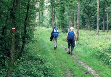
Heel mooie wandeling met veel afwisseling. Veel bospaden. Rustige landwegen.
Après les pluies et l'hiver, beaucoup beaucoup de passages boueux et glissant, et des arbres en travers. Sinon très belle balade