![](/images/other/stat-length.png)
![Randonnée Marche Stoneham-et-Tewkesbury - Le Sentier du Hiboux - Photo](https://media.geolcdn.com/t/1900/400/ext.pjpeg?maxdim=2&url=https%3A%2F%2Fstatic1.geolcdn.com%2Fsiteimages%2Fupload%2Ffiles%2F1553511878bg_sport_marche.png)
Le Sentier du Hiboux
Alizée.pee
Utilisateur GUIDE
![Longueur](/images/other/stat-length.png)
Longueur
9,2 km
![Altitude max](https://static1.geolcdn.com/siteimages/upload/files/1508320355ic_sort_altitude_max_24dp.png)
Altitude max
597 m
![Dénivelé positif](https://static1.geolcdn.com/siteimages/upload/files/1508320355ic_sort_den_pos_24dp.png)
Dénivelé positif
440 m
![Km-Effort](/images/other/stat-length.png)
Km-Effort
15,1 km
![Altitude min](https://static1.geolcdn.com/siteimages/upload/files/1508320355ic_sort_altitude_min_24dp.png)
Altitude min
248 m
![Dénivelé négatif](https://static1.geolcdn.com/siteimages/upload/files/1508320355ic_sort_den_neg_24dp.png)
Dénivelé négatif
444 m
![Boucle](https://static1.geolcdn.com/siteimages/upload/files/16400158638029165_repeat_loop_refresh_sync_direction_icon.png)
Boucle
Oui
Date de création :
2019-09-05 12:02:45.308
Dernière modification :
2019-09-05 12:03:14.319
![Marche](https://static1.geolcdn.com/sitytour/trail-icons/101.png)
3h05
Difficulté : Difficile
![Scannez ce code QR pour ouvrir la randonnée dans l'application SityTrail](https://capi.geolives.com/qq0zvz2zws4bq2lad0pu/sitytour/trails/2192309/qr.png?size=200)
Application GPS de randonnée GRATUITE
À propos
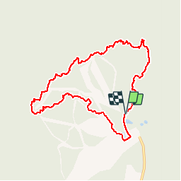
Randonnée Marche de 9,2 km à découvrir à Québec, La Jacques-Cartier, Stoneham-et-Tewkesbury. Cette randonnée est proposée par Alizée.pee.
Description
Cette randonnée assez difficile offre des vues panoramiques. Passage par de très beaux endroits. Le sentier est très bien balisé. Malgré le fait que ce sentier soit moins connu, il est à découvrir !
Localisation
Pays :
Canada
Région :
Québec
Département/Province :
La Jacques-Cartier
Commune :
Stoneham-et-Tewkesbury
Localité :
Unknown
Départ:(Dec)
Départ:(UTM)
318891 ; 5211432 (19T) N.
Commentaires
Randonnées à proximité
![Randonnée Marche Stoneham-et-Tewkesbury - Parc Mont Wright - Photo](https://media.geolcdn.com/t/375/260/ext.jpg?maxdim=2&url=https%3A%2F%2Fstatic1.geolcdn.com%2Fsiteimages%2Fupload%2Ffiles%2F1553511878bg_sport_marche.png)
![Marche Marche](https://static1.geolcdn.com/sitytour/trail-icons/101.png)
Parc Mont Wright
Marche
Moyen
Stoneham-et-Tewkesbury,
Québec,
La Jacques-Cartier,
Canada
![](/images/other/stat-length.png)
5,8 km | 9,9 km-effort
2h 1min
![](https://static1.geolcdn.com/siteimages/upload/files/16400158638029165_repeat_loop_refresh_sync_direction_icon.png)
Oui
![Randonnée Marche Stoneham-et-Tewkesbury - Mont Wright 2 - Photo](https://media.geolcdn.com/t/375/260/ext.jpg?maxdim=2&url=https%3A%2F%2Fstatic1.geolcdn.com%2Fsiteimages%2Fupload%2Ffiles%2F1553511878bg_sport_marche.png)
![Marche Marche](https://static1.geolcdn.com/sitytour/trail-icons/101.png)
Mont Wright 2
Marche
Stoneham-et-Tewkesbury,
Québec,
La Jacques-Cartier,
Canada
![](/images/other/stat-length.png)
5,7 km | 9,4 km-effort
2h 22min
![](https://static1.geolcdn.com/siteimages/upload/files/16400158638029165_repeat_loop_refresh_sync_direction_icon.png)
Oui
![Randonnée Marche Stoneham-et-Tewkesbury - Mont Wright - Photo](https://media.geolcdn.com/t/375/260/ext.jpg?maxdim=2&url=https%3A%2F%2Fstatic1.geolcdn.com%2Fsiteimages%2Fupload%2Ffiles%2F1553511878bg_sport_marche.png)
![Marche Marche](https://static1.geolcdn.com/sitytour/trail-icons/101.png)
Mont Wright
Marche
Stoneham-et-Tewkesbury,
Québec,
La Jacques-Cartier,
Canada
![](/images/other/stat-length.png)
6,5 km | 10,4 km-effort
3h 14min
![](https://static1.geolcdn.com/siteimages/upload/files/16400158638029165_repeat_loop_refresh_sync_direction_icon.png)
Oui