Randonnée Marche Dompierre - Dompierre; trace GPS du 10/09/2019 - Photo

Dompierre; trace GPS du 10/09/2019

 toporient
toporient

Utilisateur

© OpenStreetMap contributors
Longueur
Longueur
8,2 km
Altitude max
Altitude max
246 m
Dénivelé positif
Dénivelé positif
145 m
Km-Effort
Km-Effort  
10,2 km
Altitude min
Altitude min
188 m
Dénivelé négatif
Dénivelé négatif
145 m
Boucle
Boucle
Oui
Date de création :
2019-09-10 11:24:37.262
Dernière modification :
2019-09-11 16:14:37.524

(0 Avis)

Marche
Marche
4h30
Difficulté : Très facile

Scannez ce code QR pour ouvrir la randonnée dans l'application SityTrail

Application GPS de randonnée GRATUITE

Logo SityTrail SityTrail

IGN / Instituts géographiques

Télécharger SityTrail sur l'App Store Télécharger SityTrail sur Google Play

Logo SityTrail SityTrail World

Le monde est à vous

Télécharger SityTrail sur l'App Store Télécharger SityTrail sur Google Play Télécharger SityTrail sur Huawei AppGallery

À propos

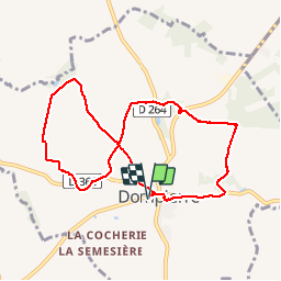
Randonnée Marche de 8,2 km à découvrir à Normandie, Orne, Dompierre. Cette randonnée est proposée par toporient.

Description

Boucle en 8 en terrain varié où alternent lignes de crête,  chemins creux et une piste empierrée.
Départ du parking sortie ouest de Dompierre sur la D21 (route de Domfront).

Profil altimétrique

Localisation

Pays :
France
Région :
Normandie
Département/Province :
Orne
Commune :
Dompierre
Localité :
Unknown
Départ:(UTM)
680240 ; 5389450 (30U) N.

Randonnées à proximité

Randonnée Marche La Ferrière-aux-Étangs - Circuit of IRON by Yannick-p14-61 - Photo
Marche
yannick-p

Marche

Moyen
(1)
La Ferrière-aux-Étangs, Normandie, Orne, France
13,3 km | 16,5 km-effort
3h 35min
Oui
Randonnée Marche La Ferrière-aux-Étangs - La Ferrière - La Ferrière aux Etangs - Photo
Marche
tracegps

Marche

Moyen
La Ferrière-aux-Étangs, Normandie, Orne, France
14,3 km | 17,9 km-effort
3h 4min
Oui
Randonnée V.T.T.  - Espace VTT FFC les Ecureuils du Domfrontais - Circuit n°14 - Champsecret - Photo
V.T.T.
tracegps

V.T.T.

Moyen
, Normandie, Orne, France
22 km | 26 km-effort
2h 0min
Oui
Randonnée Marche La Ferrière-aux-Étangs - 1h16 - Photo
Marche
Jeromefrando

Marche

Moyen
La Ferrière-aux-Étangs, Normandie, Orne, France
6,4 km | 8,5 km-effort
1h 16min
Oui
Randonnée Marche Le Châtellier - chatellier - Photo
Marche
sitydomer

Marche

Moyen
Le Châtellier, Normandie, Orne, France
6 km | 6,6 km-effort
1h 36min
Oui
Randonnée Marche Dompierre - mines - Photo
Marche
canal

Marche

Moyen
Dompierre, Normandie, Orne, France
9,3 km | 11,6 km-effort
2h 47min
Non
Randonnée Marche La Ferrière-aux-Étangs - La Feriere aux etant  - Photo
Marche
Elisabeth Neveu

Marche

Très facile
La Ferrière-aux-Étangs, Normandie, Orne, France
1,2 km | 1,3 km-effort
36min
Oui
Randonnée Marche Dompierre - Dompierre longue - Photo
Marche
toporient

Marche

Moyen
Dompierre, Normandie, Orne, France
8,3 km | 10 km-effort
2h 13min
Oui
Randonnée Marche Champsecret - Ermitage-Roches aux Dames et aux loups - Photo
Marche
toporient

Marche

Moyen
Champsecret, Normandie, Orne, France
9 km | 11 km-effort
2h 23min
Oui


Fermer
Mes abonnements