Dom et les Tarlouzes SityTrail > Randonnées > Outdoor > France > Occitanie > Gers > Bazugues SityTrail > Randonnées > Outdoor > France > Occitanie > Gers > Bazugues Dom et les Tarlouzes lucmarescot Utilisateur 3D © OpenStreetMap contributors Longueur 51 km Altitude max 295 m Dénivelé positif 736 m Km-Effort 61 km Altitude min 167 m Dénivelé négatif 712 m Boucle Non Date de création : 2014-12-10 00:00:00.0 Dernière modification : 2014-12-10 00:00:00.0 (0 Avis) V.T.T. 3h25 Difficulté : Facile Application GPS de randonnée GRATUITE SityTrail IGN / Instituts géographiques SityTrail World Le monde est à vous À propos 
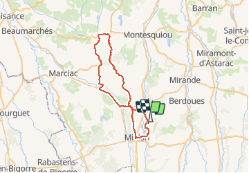
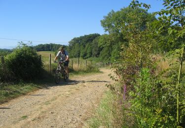
Randonnée V.T.T. de 51 km à découvrir à Occitanie, Gers, Bazugues. Cette randonnée est proposée par lucmarescot. Description VTT sur la route Légendes | Plus de détails (PDF) Profil altimétrique Légendes > 15% 15% - 10% 10% - 5% à plat 5% - 10% 10% - 15% 15% - 30% > 30% Localisation Pays : France Région : Occitanie Département/Province : Gers Commune : Bazugues Localité : Unknown Départ:(Dec) 43.451401 / 0.330398 Départ:(UTM) 284000 ; 4814406 (31T) N. Commentaires Veuillez vous connecter pour laisser un commentaire ou une note Randonnées à proximité Jean Roger Dubosc miélan Marche Très facile Miélan, Occitanie, Gers, France 2,9 km | 3,2 km-effort 1h 27min Oui tracegps Les Paguères Miélanaises V.T.T. Très difficile (1) Miélan, Occitanie, Gers, France 42 km | 52 km-effort 3h 30min Oui papounet32 Rando Mielan Marche Moyen Miélan, Occitanie, Gers, France 7,4 km | 8,4 km-effort 1h 46min Oui tracegps Les coteaux de Miélan (Gers) V.T.T. Difficile (1) Miélan, Occitanie, Gers, France 32 km | 39 km-effort 3h 0min Oui