![](/images/other/stat-length.png)
![Randonnée Marche Zemst - Wandelen door zalig groen Eppegem - Photo](https://media.geolcdn.com/t/1900/400/ext.pjpeg?maxdim=2&url=https%3A%2F%2Fstatic1.geolcdn.com%2Fsiteimages%2Fupload%2Ffiles%2F1553511878bg_sport_marche.png)
Wandelen door zalig groen Eppegem
StefPia
Utilisateur
![Longueur](/images/other/stat-length.png)
Longueur
5,5 km
![Altitude max](https://static1.geolcdn.com/siteimages/upload/files/1508320355ic_sort_altitude_max_24dp.png)
Altitude max
16 m
![Dénivelé positif](https://static1.geolcdn.com/siteimages/upload/files/1508320355ic_sort_den_pos_24dp.png)
Dénivelé positif
21 m
![Km-Effort](/images/other/stat-length.png)
Km-Effort
5,8 km
![Altitude min](https://static1.geolcdn.com/siteimages/upload/files/1508320355ic_sort_altitude_min_24dp.png)
Altitude min
5 m
![Dénivelé négatif](https://static1.geolcdn.com/siteimages/upload/files/1508320355ic_sort_den_neg_24dp.png)
Dénivelé négatif
25 m
![Boucle](https://static1.geolcdn.com/siteimages/upload/files/16400158638029165_repeat_loop_refresh_sync_direction_icon.png)
Boucle
Non
Date de création :
2020-01-28 16:36:16.0
Dernière modification :
2020-01-28 17:41:37.361
![Marche](https://static1.geolcdn.com/sitytour/trail-icons/101.png)
1h04
Difficulté : Moyen
![Scannez ce code QR pour ouvrir la randonnée dans l'application SityTrail](https://capi.geolives.com/qq0zvz2zws4bq2lad0pu/sitytour/trails/2317957/qr.png?size=200)
Application GPS de randonnée GRATUITE
À propos
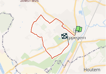
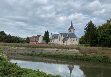
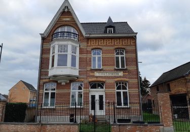
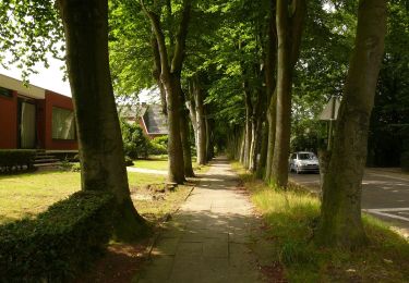
Randonnée Marche de 5,5 km à découvrir à Flandre, Brabant flamand, Zemst. Cette randonnée est proposée par StefPia.
Description
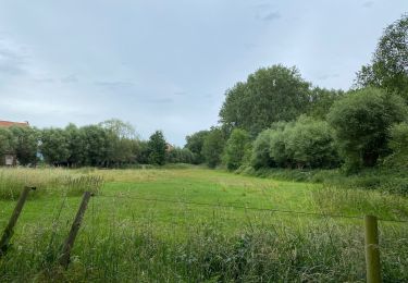
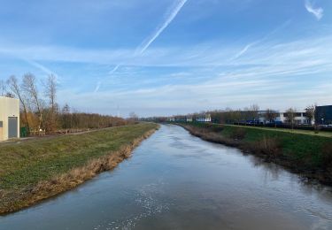
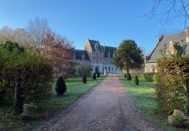
If you want to relax in quiet and rural Eppegem and escape some stress this walk is great...and not too far. You discover history and castles along the way
Localisation
Pays :
Belgique
Région :
Flandre
Département/Province :
Brabant flamand
Commune :
Zemst
Localité :
Eppegem
Départ:(Dec)
Départ:(UTM)
602170 ; 5646620 (31U) N.
Commentaires
Randonnées à proximité
![Randonnée Marche Grimbergen - Grimbergen 8 km - Photo](https://media.geolcdn.com/t/375/260/ext.jpg?maxdim=2&url=https%3A%2F%2Fmedia.geolcdn.com%2Ff%2Fb35b3f1b-a699-43d6-969b-1639eabce32f.jpg)
![Marche Marche](https://static1.geolcdn.com/sitytour/trail-icons/101.png)
Grimbergen 8 km
Marche
Moyen
(5)
Grimbergen,
Flandre,
Brabant flamand,
Belgique
![](/images/other/stat-length.png)
8,1 km | 8,6 km-effort
1h 23min
![](https://static1.geolcdn.com/siteimages/upload/files/16400158638029165_repeat_loop_refresh_sync_direction_icon.png)
Non
![Randonnée Marche Vilvorde - Vilvoorde 19,4 km - Photo](https://media.geolcdn.com/t/375/260/ext.jpg?maxdim=2&url=https%3A%2F%2Fmedia.geolcdn.com%2Ff%2F8074fc11-08d7-4b93-891e-032223b215f5.jpg)
![Marche Marche](https://static1.geolcdn.com/sitytour/trail-icons/101.png)
Vilvoorde 19,4 km
Marche
Facile
Vilvorde,
Flandre,
Brabant flamand,
Belgique
![](/images/other/stat-length.png)
19,5 km | 21 km-effort
4h 46min
![](https://static1.geolcdn.com/siteimages/upload/files/16400158638029165_repeat_loop_refresh_sync_direction_icon.png)
Oui
![Randonnée Marche Zemst - Weerde Eppegem Zemst - 8 km RT - Photo](https://media.geolcdn.com/t/375/260/ext.jpg?maxdim=2&url=https%3A%2F%2Fstatic1.geolcdn.com%2Fsiteimages%2Fupload%2Ffiles%2F1553511878bg_sport_marche.png)
![Marche Marche](https://static1.geolcdn.com/sitytour/trail-icons/101.png)
Weerde Eppegem Zemst - 8 km RT
Marche
Très facile
(1)
Zemst,
Flandre,
Brabant flamand,
Belgique
![](/images/other/stat-length.png)
8,2 km | 8,7 km-effort
Inconnu
![](https://static1.geolcdn.com/siteimages/upload/files/16400158638029165_repeat_loop_refresh_sync_direction_icon.png)
Oui
![Randonnée Marche Zemst - S-GR Dijleland : Eppegem - Veltem - Photo](https://media.geolcdn.com/t/375/260/ext.jpg?maxdim=2&url=https%3A%2F%2Fmedia.geolcdn.com%2Ff%2F25023903-3e73-4ee4-b604-18bf860fdec0.jpeg)
![Marche Marche](https://static1.geolcdn.com/sitytour/trail-icons/101.png)
S-GR Dijleland : Eppegem - Veltem
Marche
Moyen
Zemst,
Flandre,
Brabant flamand,
Belgique
![](/images/other/stat-length.png)
23 km | 25 km-effort
5h 41min
![](https://static1.geolcdn.com/siteimages/upload/files/16400158638029165_repeat_loop_refresh_sync_direction_icon.png)
Non
![Randonnée Marche Zemst - S-GR Groene Gordel: Eppegem - Mollem - Photo](https://media.geolcdn.com/t/375/260/ext.jpg?maxdim=2&url=https%3A%2F%2Fmedia.geolcdn.com%2Ff%2F14148496-c7e6-4d05-a429-ae64ab1febd3.jpeg)
![Marche Marche](https://static1.geolcdn.com/sitytour/trail-icons/101.png)
S-GR Groene Gordel: Eppegem - Mollem
Marche
Moyen
Zemst,
Flandre,
Brabant flamand,
Belgique
![](/images/other/stat-length.png)
27 km | 30 km-effort
6h 51min
![](https://static1.geolcdn.com/siteimages/upload/files/16400158638029165_repeat_loop_refresh_sync_direction_icon.png)
Non
![Randonnée A pied Zemst - Natuur-rijk Elewijt - Photo](https://media.geolcdn.com/t/375/260/ext.jpg?maxdim=2&url=https%3A%2F%2Fmedia.geolcdn.com%2Ff%2F08e56341-a52a-4793-9f22-4f3328419953.jpeg)
![A pied A pied](https://static1.geolcdn.com/sitytour/trail-icons/100.png)
Natuur-rijk Elewijt
A pied
Facile
Zemst,
Flandre,
Brabant flamand,
Belgique
![](/images/other/stat-length.png)
10,6 km | 11,5 km-effort
2h 36min
![](https://static1.geolcdn.com/siteimages/upload/files/16400158638029165_repeat_loop_refresh_sync_direction_icon.png)
Oui
![Randonnée A pied Vilvorde - Trage Wegen - Photo](https://media.geolcdn.com/t/375/260/ext.jpg?maxdim=2&url=https%3A%2F%2Fmedia.geolcdn.com%2Ff%2Fb8b38987-bb69-4058-9274-bd2555eadcd2.jpeg)
![A pied A pied](https://static1.geolcdn.com/sitytour/trail-icons/100.png)
Trage Wegen
A pied
Facile
Vilvorde,
Flandre,
Brabant flamand,
Belgique
![](/images/other/stat-length.png)
4,9 km | 5,2 km-effort
1h 11min
![](https://static1.geolcdn.com/siteimages/upload/files/16400158638029165_repeat_loop_refresh_sync_direction_icon.png)
Non
![Randonnée A pied Zemst - 5 km looproute - Photo](https://media.geolcdn.com/t/375/260/ext.jpg?maxdim=2&url=https%3A%2F%2Fmedia.geolcdn.com%2Ff%2F5bf54057-1682-421e-b778-f05b4be0d342.jpeg)
![A pied A pied](https://static1.geolcdn.com/sitytour/trail-icons/100.png)
5 km looproute
A pied
Facile
Zemst,
Flandre,
Brabant flamand,
Belgique
![](/images/other/stat-length.png)
5 km | 5,5 km-effort
1h 15min
![](https://static1.geolcdn.com/siteimages/upload/files/16400158638029165_repeat_loop_refresh_sync_direction_icon.png)
Oui
![Randonnée A pied Zemst - Weerdse Kronkels - Photo](https://media.geolcdn.com/t/375/260/ext.jpg?maxdim=2&url=https%3A%2F%2Fmedia.geolcdn.com%2Ff%2F1a8287f3-ddc8-4a38-9508-75b884259afe.jpeg)
![A pied A pied](https://static1.geolcdn.com/sitytour/trail-icons/100.png)
Weerdse Kronkels
A pied
Facile
Zemst,
Flandre,
Brabant flamand,
Belgique
![](/images/other/stat-length.png)
7,6 km | 8,1 km-effort
1h 50min
![](https://static1.geolcdn.com/siteimages/upload/files/16400158638029165_repeat_loop_refresh_sync_direction_icon.png)
Oui