


Veigné - boucles via GR46A - 19.9km 210m 4h20 - 2020 05 29

Orcal37
Utilisateur GUIDE
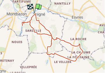

Longueur
19,9 km

Altitude max
96 m

Dénivelé positif
215 m
Km-Effort
23 km

Altitude min
53 m

Dénivelé négatif
214 m
Boucle
Oui
Date de création :
2020-05-29 12:37:50.452
Dernière modification :
2021-09-08 13:18:22.155
4h20
Difficulté : Facile

Application GPS de randonnée GRATUITE
 SityTrail
IGN / Instituts géographiques
SityTrail Plus
Le monde est à vous
À propos
Randonnée Marche de 19,9 km à découvrir à Centre-Val de Loire, Indre-et-Loire, Veigné. Cette randonnée est proposée par Orcal37.
Description
Veigné - boucles via GR46A - 19.9km 210m 4h20 - 2020 05 29
Photos


Localisation
Pays :
France
Région :
Centre-Val de Loire
Département/Province :
Indre-et-Loire
Commune :
Veigné
Localité :
Unknown
Départ:(Dec)
Départ:(UTM)
328781 ; 5239647 (31T) N.
Commentaires