


30 - CENDRAS - Les Hauts De Cendras - 8.3 km - 3h00 - D 280 m

dansmabulle
Utilisateur
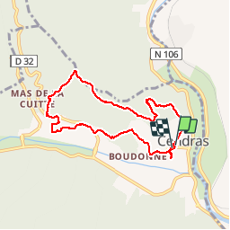

Longueur
8,3 km

Altitude max
313 m

Dénivelé positif
257 m
Km-Effort
11,7 km

Altitude min
149 m

Dénivelé négatif
259 m
Boucle
Oui
Date de création :
2014-12-10 00:00:00.0
Dernière modification :
2014-12-10 00:00:00.0
2h31
Difficulté : Moyen

Application GPS de randonnée GRATUITE
 SityTrail
IGN / Instituts géographiques
SityTrail Plus
Le monde est à vous
À propos
Randonnée Marche de 8,3 km à découvrir à Occitanie, Gard, Cendras. Cette randonnée est proposée par dansmabulle.
Localisation
Pays :
France
Région :
Occitanie
Département/Province :
Gard
Commune :
Cendras
Localité :
Unknown
Départ:(Dec)
Départ:(UTM)
584268 ; 4889751 (31T) N.
Commentaires