Randonnée Marche Remilly-en-Montagne - remilly en montagne - agey - remilly  - Photo
 bouthors21
bouthors21

Utilisateur

© OpenStreetMap contributors
Longueur
Longueur
5,3 km
Altitude max
Altitude max
419 m
Dénivelé positif
Dénivelé positif
159 m
Km-Effort
Km-Effort  
7,5 km
Altitude min
Altitude min
315 m
Dénivelé négatif
Dénivelé négatif
161 m
Boucle
Boucle
Oui
Date de création :
2020-07-15 11:59:55.502
Dernière modification :
2020-07-15 13:19:42.432

(0 Avis)

Marche
Marche
1h19
Difficulté : Très facile

Scannez ce code QR pour ouvrir la randonnée dans l'application SityTrail

Application GPS de randonnée GRATUITE

Logo SityTrail SityTrail

IGN / Instituts géographiques

Télécharger SityTrail sur l'App Store Télécharger SityTrail sur Google Play

Logo SityTrail SityTrail World

Le monde est à vous

Télécharger SityTrail sur l'App Store Télécharger SityTrail sur Google Play Télécharger SityTrail sur Huawei AppGallery

À propos

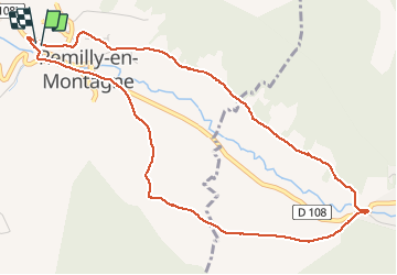
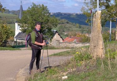
Randonnée Marche de 5,3 km à découvrir à Bourgogne-Franche-Comté, Côte-d'Or, Remilly-en-Montagne. Cette randonnée est proposée par bouthors21.

Description

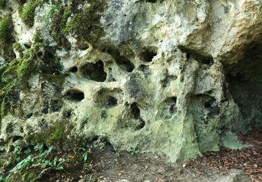
petite boucle par les vignes à l'aller et par la forêt au retour

Profil altimétrique

Localisation

Pays :
France
Région :
Bourgogne-Franche-Comté
Département/Province :
Côte-d'Or
Commune :
Remilly-en-Montagne
Localité :
Unknown
Départ:(UTM)
630950 ; 5239122 (31T) N.

Randonnées à proximité

Randonnée Marche Barbirey-sur-Ouche - Le Tour de Barbiriacum - Barbirey sur Ouche - Photo
Marche
tracegps

Marche

Moyen
(1)
Barbirey-sur-Ouche, Bourgogne-Franche-Comté, Côte-d'Or, France
10,5 km | 15,9 km-effort
2h 45min
Oui
Randonnée Marche Mâlain - Mâlain - Charmoy - Baulme le Roche - Photo
Marche
tracegps

Marche

Moyen
(3)
Mâlain, Bourgogne-Franche-Comté, Côte-d'Or, France
15,3 km | 21 km-effort
3h 30min
Oui
Randonnée A pied Mâlain - Sentier du Mâlain - Photo
A pied
PRO

A pied

Facile
Mâlain, Bourgogne-Franche-Comté, Côte-d'Or, France
6,6 km | 10,5 km-effort
2h 22min
Oui
Randonnée Marche Grenant-lès-Sombernon - Grenant les sombernon  - Photo
Marche
eric.guyard21

Marche

Grenant-lès-Sombernon, Bourgogne-Franche-Comté, Côte-d'Or, France
14 km | 21 km-effort
3h 35min
Oui
Randonnée Marche Barbirey-sur-Ouche - Tebzima - Photo
Marche
dominiq

Marche

Moyen
Barbirey-sur-Ouche, Bourgogne-Franche-Comté, Côte-d'Or, France
13,4 km | 20 km-effort
4h 11min
Oui
Randonnée A pied Barbirey-sur-Ouche - barbirey - Photo
A pied
mpstoop

A pied

Moyen
Barbirey-sur-Ouche, Bourgogne-Franche-Comté, Côte-d'Or, France
15,5 km | 23 km-effort
2min
Oui
Randonnée Marche Barbirey-sur-Ouche - barbirey sur Ouche  - Photo
Marche
Montagne71

Marche

Moyen
Barbirey-sur-Ouche, Bourgogne-Franche-Comté, Côte-d'Or, France
19,4 km | 28 km-effort
6h 59min
Non
Randonnée Marche Barbirey-sur-Ouche - Tour Denis Gaillard Barbirey sur ouche - Photo
Marche
Barbirotin21

Marche

Moyen
Barbirey-sur-Ouche, Bourgogne-Franche-Comté, Côte-d'Or, France
6,2 km | 8,7 km-effort
2h 0min
Oui
Randonnée V.T.T. Sainte-Marie-sur-Ouche - Ste Marie st Jean de Boeuf Antheuil Retour Canal - Photo
V.T.T.
mricard

V.T.T.

Moyen
Sainte-Marie-sur-Ouche, Bourgogne-Franche-Comté, Côte-d'Or, France
40 km | 48 km-effort
3h 55min
Oui


Fermer
Mes abonnements