Randonnée Marche Saint-Martin-la-Plaine - 20200723...De St-Martin-la-Plaine à Ste Catherine - Photo

20200723...De St-Martin-la-Plaine à Ste Catherine

 galain
galain

Utilisateur

© OpenStreetMap contributors
Longueur
Longueur
26 km
Altitude max
Altitude max
823 m
Dénivelé positif
Dénivelé positif
701 m
Km-Effort
Km-Effort  
36 km
Altitude min
Altitude min
313 m
Dénivelé négatif
Dénivelé négatif
701 m
Boucle
Boucle
Oui
Date de création :
2020-07-23 07:08:48.0
Dernière modification :
2020-07-24 10:03:59.495

(0 Avis)

Marche
Marche
6h11
Difficulté : Moyen

Scannez ce code QR pour ouvrir la randonnée dans l'application SityTrail

Application GPS de randonnée GRATUITE

Logo SityTrail SityTrail

IGN / Instituts géographiques

Télécharger SityTrail sur l'App Store Télécharger SityTrail sur Google Play

Logo SityTrail SityTrail World

Le monde est à vous

Télécharger SityTrail sur l'App Store Télécharger SityTrail sur Google Play Télécharger SityTrail sur Huawei AppGallery

À propos

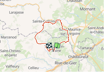
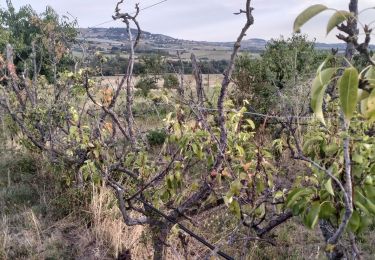
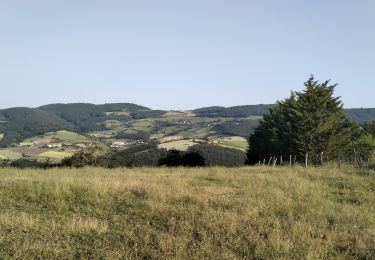
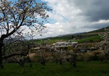
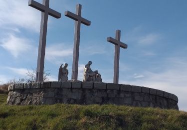
Randonnée Marche de 26 km à découvrir à Auvergne-Rhône-Alpes, Loire, Saint-Martin-la-Plaine. Cette randonnée est proposée par galain.

Description

Joli parcours en boucle de 26 kms empruntant parfois l'ancien tracé d'une ligne de chemin de fer et de belles grimpettes en perspective.
Possibilité de casser la croûte à plusieurs endroits.

Profil altimétrique

Photos

Localisation

Pays :
France
Région :
Auvergne-Rhône-Alpes
Département/Province :
Loire
Commune :
Saint-Martin-la-Plaine
Localité :
Unknown
Départ:(Dec)
Départ:(UTM)
624022 ; 5044990 (31T) N.

Randonnées à proximité

Randonnée Marche La Grand-Croix - MOYENNE MARCHE - Photo
Marche
CLERJON

Marche

Très facile
(1)
La Grand-Croix, Auvergne-Rhône-Alpes, Loire, France
3,8 km | 5 km-effort
1h 1min
Oui
Randonnée Marche Chagnon - 42_Chagnon_13km470m - Photo
Marche
SyMA

Marche

Moyen
Chagnon, Auvergne-Rhône-Alpes, Loire, France
13,1 km | 19,3 km-effort
2h 58min
Oui
Randonnée Marche Saint-Joseph - 42-st-joseph-10km-320m - Photo
Marche
SyMA

Marche

Facile
Saint-Joseph, Auvergne-Rhône-Alpes, Loire, France
10,5 km | 14,8 km-effort
2h 50min
Oui
Randonnée Marche Chabanière - 69-st-maurice-dargoire2-19km-580m - Photo
Marche
SyMA

Marche

Difficile
Chabanière, Auvergne-Rhône-Alpes, Rhône, France
19,2 km | 27 km-effort
5h 47min
Oui
Randonnée Marche Chabanière - 69_st_maurice_dargeoire_12km_300m - Photo
Marche
SyMA

Marche

Moyen
Chabanière, Auvergne-Rhône-Alpes, Rhône, France
11,6 km | 15,5 km-effort
3h 31min
Oui
Randonnée Marche Saint-Martin-la-Plaine - 42-martinlaplaine-12km450m - Photo
Marche
SyMA

Marche

Difficile
Saint-Martin-la-Plaine, Auvergne-Rhône-Alpes, Loire, France
12,9 km | 18,9 km-effort
4h 17min
Oui
Randonnée Marche Saint-Martin-la-Plaine - rando autour de St Martin la plaine,  - Photo
Marche
mimi69670

Marche

Facile
Saint-Martin-la-Plaine, Auvergne-Rhône-Alpes, Loire, France
10,4 km | 13,6 km-effort
3h 6min
Oui
Randonnée Marche Cellieu - Cellier Valfleurie - Photo
Marche
PhilDomDoxa

Marche

Moyen
Cellieu, Auvergne-Rhône-Alpes, Loire, France
19,3 km | 29 km-effort
4h 37min
Non
Randonnée Marche Cellieu - cellieu partiel pournphotos - Photo
Marche
PhilDomDoxa

Marche

Moyen
Cellieu, Auvergne-Rhône-Alpes, Loire, France
11 km | 17,9 km-effort
2h 37min
Non


Fermer
Mes abonnements