


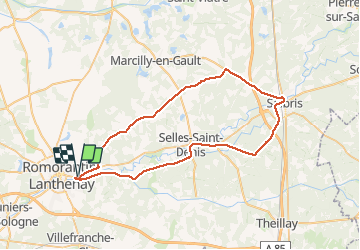
romo loreux salbris rte teillay ferthe Imbault romo

mimilolo
Utilisateur

Longueur
57 km

Altitude max
134 m

Dénivelé positif
450 m
Km-Effort
63 km

Altitude min
86 m

Dénivelé négatif
450 m
Boucle
Oui
Date de création :
2020-08-09 06:43:53.887
Dernière modification :
2020-08-09 10:55:48.298
2h10
Difficulté : Très facile

Application GPS de randonnée GRATUITE
 SityTrail
IGN / Instituts géographiques
SityTrail Plus
Le monde est à vous
À propos
Randonnée Vélo de route de 57 km à découvrir à Centre-Val de Loire, Loir-et-Cher, Romorantin-Lanthenay. Cette randonnée est proposée par mimilolo.
Localisation
Pays :
France
Région :
Centre-Val de Loire
Département/Province :
Loir-et-Cher
Commune :
Romorantin-Lanthenay
Localité :
Unknown
Départ:(Dec)
Départ:(UTM)
407020 ; 5245703 (31T) N.
Commentaires