Randonnée Marche Gressan - Pila - Photo
 tchatelain
tchatelain

Utilisateur

© OpenStreetMap contributors
Longueur
Longueur
11 km
Altitude max
Altitude max
3053 m
Dénivelé positif
Dénivelé positif
1482 m
Km-Effort
Km-Effort  
31 km
Altitude min
Altitude min
1859 m
Dénivelé négatif
Dénivelé négatif
1467 m
Boucle
Boucle
Oui
Date de création :
2020-08-11 06:31:43.521
Dernière modification :
2020-08-11 15:44:28.336

(0 Avis)

Marche
Marche
9h12
Difficulté : Très facile

Scannez ce code QR pour ouvrir la randonnée dans l'application SityTrail

Application GPS de randonnée GRATUITE

Logo SityTrail SityTrail

IGN / Instituts géographiques

Télécharger SityTrail sur l'App Store Télécharger SityTrail sur Google Play

Logo SityTrail SityTrail World

Le monde est à vous

Télécharger SityTrail sur l'App Store Télécharger SityTrail sur Google Play Télécharger SityTrail sur Huawei AppGallery

À propos

Randonnée Marche de 11 km à découvrir à Vallée d'Aoste, Inconnu, Gressan. Cette randonnée est proposée par tchatelain.

Profil altimétrique

Localisation

Pays :
Italie
Région :
Vallée d'Aoste
Département/Province :
Inconnu
Commune :
Gressan
Localité :
Unknown
Départ:(UTM)
368435 ; 5060022 (32T) N.

Randonnées à proximité

Randonnée Marche Gressan - pila  - Photo
Marche
titim

Marche

Très facile
(1)
Gressan, Vallée d'Aoste, Inconnu, Italie
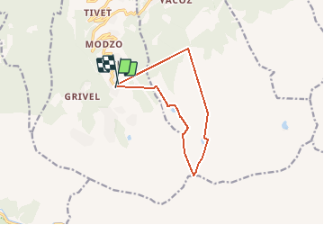
10,8 km | 18,5 km-effort
4h 32min
Oui
Randonnée Marche Aymavilles - vignes - Photo
Marche
Nathalie Frison

Marche

Moyen
Aymavilles, Vallée d'Aoste, Inconnu, Italie
3,1 km | 4,2 km-effort
1h 8min
Oui
Randonnée Marche Gressan - alpi.  lac chamolé  aller par piste retour par sentier - Photo
Marche
stef789

Marche

Très facile
Gressan, Vallée d'Aoste, Inconnu, Italie
12 km | 0 m-effort
4h 34min
Non
Randonnée Ski de randonnée Gressan - Pointe du Drink - Photo
Ski de randonnée
jcolonnadelega

Ski de randonnée

Très facile
Gressan, Vallée d'Aoste, Inconnu, Italie
11,6 km | 25 km-effort
5h 24min
Oui
Randonnée Marche Charvensod - lago di chamole - Photo
Marche
titim

Marche

Très facile
Charvensod, Vallée d'Aoste, Inconnu, Italie
7,8 km | 16,5 km-effort
Inconnu
Oui
Randonnée Marche Charvensod - 700 - Photo
Marche
titim

Marche

Très facile
Charvensod, Vallée d'Aoste, Inconnu, Italie
7,8 km | 16,5 km-effort
Inconnu
Oui
Randonnée Marche Gressan - refuge d'Arbolle 13-08-19 - Photo
Marche
legios84

Marche

Moyen
Gressan, Vallée d'Aoste, Inconnu, Italie
3,1 km | 7,3 km-effort
2h 11min
Non
Randonnée Marche Gressan - Pila - Photo
Marche
jhw

Marche

Facile
Gressan, Vallée d'Aoste, Inconnu, Italie
9,6 km | 18,5 km-effort
3h 42min
Oui
Randonnée Via ferrata Gressan - Monte Emilius - Photo
Via ferrata
mpignon

Via ferrata

Très difficile
Gressan, Vallée d'Aoste, Inconnu, Italie
26 km | 57 km-effort
12h 10min
Oui


Fermer
Mes abonnements