Randonnée Marche Lay-Saint-Christophe - Lay Saint Christophe  - Photo
 JJG54
JJG54

Utilisateur

© OpenStreetMap contributors
Longueur
Longueur
12,3 km
Altitude max
Altitude max
378 m
Dénivelé positif
Dénivelé positif
212 m
Km-Effort
Km-Effort  
15,2 km
Altitude min
Altitude min
245 m
Dénivelé négatif
Dénivelé négatif
214 m
Boucle
Boucle
Oui
Date de création :
2020-10-27 12:56:42.776
Dernière modification :
2020-10-27 16:22:21.941

(0 Avis)

Marche
Marche
2h52
Difficulté : Moyen

Scannez ce code QR pour ouvrir la randonnée dans l'application SityTrail

Application GPS de randonnée GRATUITE

Logo SityTrail SityTrail

IGN / Instituts géographiques

Télécharger SityTrail sur l'App Store Télécharger SityTrail sur Google Play

Logo SityTrail SityTrail World

Le monde est à vous

Télécharger SityTrail sur l'App Store Télécharger SityTrail sur Google Play Télécharger SityTrail sur Huawei AppGallery

À propos

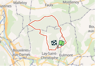
Randonnée Marche de 12,3 km à découvrir à Grand Est, Meurthe-et-Moselle, Lay-Saint-Christophe. Cette randonnée est proposée par JJG54.

Description

Départ en haut de la rue des sapins

Profil altimétrique

Photos

Localisation

Pays :
France
Région :
Grand Est
Département/Province :
Meurthe-et-Moselle
Commune :
Lay-Saint-Christophe
Localité :
Unknown
Départ:(UTM)
295076 ; 5403881 (32U) N.

Randonnées à proximité

Randonnée A pied Champigneulles - Circuit du Val Saint-Barthélémy - Photo
A pied
PRO

A pied

Facile
Champigneulles, Grand Est, Meurthe-et-Moselle, France
7 km | 8,6 km-effort
1h 57min
Oui
Randonnée A pied Agincourt - Circuit M - Photo
A pied
PRO

A pied

Facile
Agincourt, Grand Est, Meurthe-et-Moselle, France
13,3 km | 17,8 km-effort
4h 3min
Non
Randonnée Cyclotourisme Frouard - 4ème rando vélo Frouard - Lagarde 62 km - Photo
Cyclotourisme
GUIDE
jeanmarcMasson

Cyclotourisme

Très difficile
Frouard, Grand Est, Meurthe-et-Moselle, France
62 km | 67 km-effort
4h 32min
Non
Randonnée A pied Lay-Saint-Christophe - Circuit L - Photo
A pied
PRO

A pied

Facile
Lay-Saint-Christophe, Grand Est, Meurthe-et-Moselle, France
14,7 km | 18,5 km-effort
4h 11min
Oui
Randonnée A pied Champigneulles - Circuit du Vallum de la Fourasse - Photo
A pied
PRO

A pied

Facile
Champigneulles, Grand Est, Meurthe-et-Moselle, France
3,3 km | 4,9 km-effort
1h 6min
Oui
Randonnée A pied Bouxières-aux-Dames - Circuit moyenne ceinture - Photo
A pied
PRO

A pied

Facile
Bouxières-aux-Dames, Grand Est, Meurthe-et-Moselle, France
3,8 km | 5,3 km-effort
1h 12min
Oui
Randonnée Marche Montenoy - MONTENOY - LE COL DE VASSUCHAMP - Photo
Marche
jean-marie.parachini

Marche

Facile
Montenoy, Grand Est, Meurthe-et-Moselle, France
12,4 km | 16,4 km-effort
4h 33min
Oui
Randonnée Marche Eulmont - Eulmont_La tour du Crany_10kms - Photo
Marche
Marin B

Marche

Difficile
(1)
Eulmont, Grand Est, Meurthe-et-Moselle, France
9,6 km | 12,6 km-effort
2h 51min
Oui
Randonnée Marche Dommartemont - Dommartemont  - Photo
Marche
JJG54

Marche

Moyen
Dommartemont, Grand Est, Meurthe-et-Moselle, France
29 km | 34 km-effort
3h 5min
Non


Fermer
Mes abonnements