Randonnée Marche Saint-Hubert - MIRWART ... mon beau miroir ! - Photo

MIRWART ... mon beau miroir !

 GerardBouche
GerardBouche

Utilisateur

© OpenStreetMap contributors
Longueur
Longueur
11,2 km
Altitude max
Altitude max
417 m
Dénivelé positif
Dénivelé positif
278 m
Km-Effort
Km-Effort  
14,9 km
Altitude min
Altitude min
266 m
Dénivelé négatif
Dénivelé négatif
284 m
Boucle
Boucle
Oui
Date de création :
2020-11-06 10:53:54.111
Dernière modification :
2020-11-06 16:49:46.971

(1 Avis)

Marche
Marche
2h37
Difficulté : Moyen

Scannez ce code QR pour ouvrir la randonnée dans l'application SityTrail

Application GPS de randonnée GRATUITE

Logo SityTrail SityTrail

IGN / Instituts géographiques

Télécharger SityTrail sur l'App Store Télécharger SityTrail sur Google Play

Logo SityTrail SityTrail World

Le monde est à vous

Télécharger SityTrail sur l'App Store Télécharger SityTrail sur Google Play Télécharger SityTrail sur Huawei AppGallery

À propos

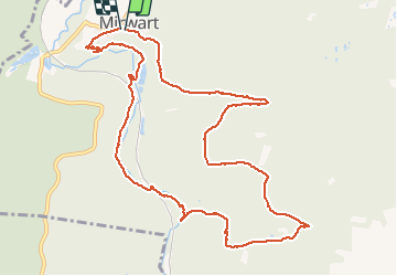
Randonnée Marche de 11,2 km à découvrir à Wallonie, Luxembourg, Saint-Hubert. Cette randonnée est proposée par GerardBouche.

Description

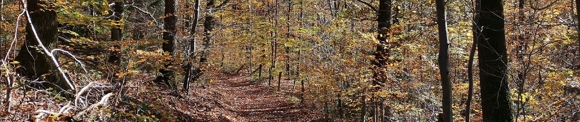
Très belle randonnée forestière par le lieu dit " Tier à Bruyère " dans le " Bois St-Hubert " jusqu'à la chapelle Notre-Dame de Bon Secours. La descente vers le  Rocher de Marie de Gobaille (... ma sorcière bien aimée !) avant de retrouver la Lhomme, une ancienne glacière d'intérêt scientifique abritant maintenant la chauve-souris "pipistrelle", l'étang St-Roch et par un sentier sinueux , le Château de Mirwart.

Profil altimétrique

Photos

Localisation

Pays :
Belgique
Région :
Wallonie
Département/Province :
Luxembourg
Commune :
Saint-Hubert
Localité :
Mirwart
Départ:(UTM)
662117 ; 5547341 (31U) N.

Commentaires

Veuillez vous connecter pour laisser un commentaire ou une note


Randonnées à proximité

Randonnée Marche Tellin - Tellin. Natura 2000, des sites qui valent le détour ! Lx 7 - Photo
Marche
GUIDE+

Marche

Moyen
(6)
Tellin, Wallonie, Luxembourg, Belgique
9,6 km | 11,9 km-effort
1h 30min
Oui
Randonnée Marche Saint-Hubert - Poix - Sainte-Adeline (SH15) - Photo
Marche
GUIDE+

Marche

Moyen
(7)
Saint-Hubert, Wallonie, Luxembourg, Belgique
8,3 km | 10,8 km-effort
2h 23min
Oui
Randonnée Marche Saint-Hubert - Mirwart_Vieux Moulin de Mirwart_Alternative Forêt (SH29 bis) - Photo
Marche
GUIDE+

Marche

Difficile
(11)
Saint-Hubert, Wallonie, Luxembourg, Belgique
10,8 km | 14,2 km-effort
3h 4min
Oui
Randonnée Marche Tellin - RL-GG-13_Grupont_Poix-Saint-Hubert - Photo
Marche
PRO

Marche

Très difficile
(2)
Tellin, Wallonie, Luxembourg, Belgique
26 km | 34 km-effort
7h 23min
Non
Randonnée Marche Tellin - Balade à Grupont - Photo
Marche
GUIDE
Desrumaux

Marche

Facile
(1)
Tellin, Wallonie, Luxembourg, Belgique
8,4 km | 11,9 km-effort
2h 33min
Oui
Randonnée Marche Tellin - Bure - Promenade des chapelles - Photo
Marche
GUIDE+

Marche

Facile
(1)
Tellin, Wallonie, Luxembourg, Belgique
4,5 km | 5,9 km-effort
1h 15min
Oui
Randonnée Marche Tellin - Tellin - Promenade du trou des Lûtons - Photo
Marche
GUIDE+

Marche

Facile
(1)
Tellin, Wallonie, Luxembourg, Belgique
5,2 km | 6,1 km-effort
1h 21min
Oui
Randonnée A pied Tellin - Tellin - Promenade des étangs - Photo
A pied
GUIDE+

A pied

Moyen
(2)
Tellin, Wallonie, Luxembourg, Belgique
20 km | 27 km-effort
Inconnu
Oui
Randonnée Marche Tellin - Grupont - Promenade du bois de Machi - Photo
Marche
GUIDE+

Marche

Moyen
(1)
Tellin, Wallonie, Luxembourg, Belgique
8,6 km | 12,6 km-effort
2h 37min
Oui


Fermer
Mes abonnements