Randonnée Marche Châtelus - grotte de pabro  - Photo
 bymarc26
bymarc26

Utilisateur

© OpenStreetMap contributors
Longueur
Longueur
6,9 km
Altitude max
Altitude max
1131 m
Dénivelé positif
Dénivelé positif
748 m
Km-Effort
Km-Effort  
16,9 km
Altitude min
Altitude min
532 m
Dénivelé négatif
Dénivelé négatif
747 m
Boucle
Boucle
Oui
Date de création :
2014-12-10 00:00:00.0
Dernière modification :
2014-12-10 00:00:00.0

(0 Avis)

Marche
Marche
3h27
Difficulté : Très difficile

Scannez ce code QR pour ouvrir la randonnée dans l'application SityTrail

Application GPS de randonnée GRATUITE

Logo SityTrail SityTrail

IGN / Instituts géographiques

Télécharger SityTrail sur l'App Store Télécharger SityTrail sur Google Play

Logo SityTrail SityTrail World

Le monde est à vous

Télécharger SityTrail sur l'App Store Télécharger SityTrail sur Google Play Télécharger SityTrail sur Huawei AppGallery

À propos

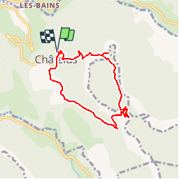
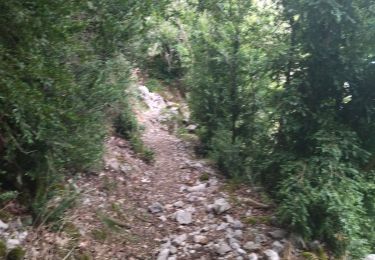
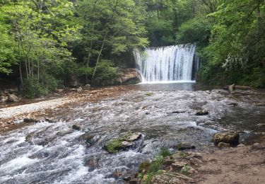
Randonnée Marche de 6,9 km à découvrir à Auvergne-Rhône-Alpes, Isère, Châtelus. Cette randonnée est proposée par bymarc26.

Description

montée depuis chatelus vers le pas de pabro - détour jusqu'à la grotte de pabro - montée sur le plateau de la grande cournouse (attention très difficile même si des cordes sont installées) retour par le pas des voûtes

Profil altimétrique

Localisation

Pays :
France
Région :
Auvergne-Rhône-Alpes
Département/Province :
Isère
Commune :
Châtelus
Localité :
Unknown
Départ:(Dec)
Départ:(UTM)
686885 ; 4992091 (31T) N.

Randonnées à proximité

Randonnée Marche Châtelus - Boucle Pas de l'Allier - Pas des Voutes - Photo
Marche
tracegps

Marche

Moyen
(1)
Châtelus, Auvergne-Rhône-Alpes, Isère, France
10,1 km | 22 km-effort
4h 30min
Oui
Randonnée Autre activité Saint-Martin-en-Vercors - Cournouses pas de l'allier - Photo
Autre activité
collot

Autre activité

Moyen
(1)
Saint-Martin-en-Vercors, Auvergne-Rhône-Alpes, Drôme, France
11 km | 21 km-effort
5h 0min
Oui
Randonnée Marche Choranche - La Grotte de Choranche - Photo
Marche
grfamily

Marche

Difficile
(1)
Choranche, Auvergne-Rhône-Alpes, Isère, France
17,8 km | 33 km-effort
7h 6min
Oui
Randonnée Marche Presles - Presles - rando amandière - (1) - Photo
Marche
calvaYnada

Marche

Très facile
(1)
Presles, Auvergne-Rhône-Alpes, Isère, France
5,6 km | 7,3 km-effort
1h 39min
Oui
Randonnée sport Saint-Laurent-en-Royans - St Laurent en Royans. La Laurentine - Photo
sport
alinetpierre

sport

Très facile
Saint-Laurent-en-Royans, Auvergne-Rhône-Alpes, Drôme, France
16,3 km | 27 km-effort
Inconnu
Oui
Randonnée V.T.T. Presles - Presles  - Photo
V.T.T.
crocau

V.T.T.

Facile
(1)
Presles, Auvergne-Rhône-Alpes, Isère, France
10,4 km | 14,9 km-effort
2h 26min
Oui
Randonnée Marche Sainte-Eulalie-en-Royans - 26 ste eulalie - Photo
Marche
himba26100

Marche

Moyen
Sainte-Eulalie-en-Royans, Auvergne-Rhône-Alpes, Drôme, France
14,8 km | 27 km-effort
6h 43min
Non
Randonnée Marche Châtelus - 38 pabro charmatte - Photo
Marche
himba26100

Marche

Difficile
Châtelus, Auvergne-Rhône-Alpes, Isère, France
11,4 km | 29 km-effort
7h 43min
Oui
Randonnée Marche nordique Saint-Laurent-en-Royans - Circuit entre Saint-Laurent-en-Royans et Pont-en-Royans - Photo
Marche nordique
Emelle

Marche nordique

Moyen
Saint-Laurent-en-Royans, Auvergne-Rhône-Alpes, Drôme, France
13 km | 17,4 km-effort
5h 9min
Oui


Fermer
Mes abonnements