Randonnée V.T.T. Bethoncourt - Rando VTT 2014 - Photo
 julien.millier
julien.millier

Utilisateur

© OpenStreetMap contributors
Longueur
Longueur
63 km
Altitude max
Altitude max
501 m
Dénivelé positif
Dénivelé positif
1436 m
Km-Effort
Km-Effort  
82 km
Altitude min
Altitude min
315 m
Dénivelé négatif
Dénivelé négatif
1356 m
Boucle
Boucle
Non
Date de création :
2014-12-10 00:00:00.0
Dernière modification :
2014-12-10 00:00:00.0

(0 Avis)

V.T.T.
V.T.T.
4h35
Difficulté : Moyen

Scannez ce code QR pour ouvrir la randonnée dans l'application SityTrail

Application GPS de randonnée GRATUITE

Logo SityTrail SityTrail

IGN / Instituts géographiques

Télécharger SityTrail sur l'App Store Télécharger SityTrail sur Google Play

Logo SityTrail SityTrail World

Le monde est à vous

Télécharger SityTrail sur l'App Store Télécharger SityTrail sur Google Play Télécharger SityTrail sur Huawei AppGallery

À propos

Randonnée V.T.T. de 63 km à découvrir à Bourgogne-Franche-Comté, Doubs, Bethoncourt. Cette randonnée est proposée par julien.millier.

Description

départ Bethoncourt

Profil altimétrique

Points d'intérêt

Point d'intérêt Héricourt - Fort du Mont Vaudois - Photo
julien.millier

Localisation

Pays :
France
Région :
Bourgogne-Franche-Comté
Département/Province :
Doubs
Commune :
Bethoncourt
Localité :
Unknown
Départ:(Dec)
Départ:(UTM)
333847 ; 5266536 (32T) N.

Randonnées à proximité

Randonnée Marche Héricourt - La Pierre Plate - Héricourt - Photo
Marche
tracegps

Marche

Difficile
(3)
Héricourt, Bourgogne-Franche-Comté, Haute-Saône, France
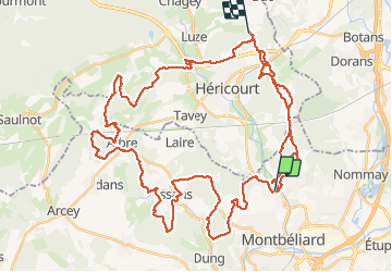
12 km | 16,4 km-effort
3h 10min
Oui
Randonnée Marche Dung - dung - Photo
Marche
Evelyne3

Marche

Difficile
Dung, Bourgogne-Franche-Comté, Doubs, France
11,5 km | 15,8 km-effort
2h 24min
Oui
Randonnée Marche Héricourt - Héricourt - Pierre Plate - Sentier de découverte - Photo
Marche
Bart2015

Marche

Moyen
Héricourt, Bourgogne-Franche-Comté, Haute-Saône, France
12,3 km | 16,7 km-effort
2h 20min
Oui
Randonnée sport Montbéliard - Marche de Noël  - Photo
sport
klopbill

sport

Très facile
Montbéliard, Bourgogne-Franche-Comté, Doubs, France
9,1 km | 10,7 km-effort
Inconnu
Non
Randonnée V.T.T. Montbéliard - rando VTT club de montbeliard  - Photo
V.T.T.
francislassauce

V.T.T.

Très difficile
Montbéliard, Bourgogne-Franche-Comté, Doubs, France
44 km | 56 km-effort
3h 45min
Oui
Randonnée Marche Montbéliard - zz - Photo
Marche
Denis Roussel

Marche

Très difficile
Montbéliard, Bourgogne-Franche-Comté, Doubs, France
161 km | 203 km-effort
40h 22min
Non
Randonnée Cyclotourisme Arbouans - GTJ #1 - Photo
Cyclotourisme
GUIDE
David25400

Cyclotourisme

Très difficile
Arbouans, Bourgogne-Franche-Comté, Doubs, France
108 km | 142 km-effort
10h 18min
Non
Randonnée Marche Brognard - allenjoie - Photo
Marche
Papamoju

Marche

Très facile
Brognard, Bourgogne-Franche-Comté, Doubs, France
14 km | 15,3 km-effort
3h 52min
Oui
Randonnée Marche Vyans-le-Val - vyans le val - Photo
Marche
Fillatre

Marche

Moyen
Vyans-le-Val, Bourgogne-Franche-Comté, Haute-Saône, France
7 km | 9 km-effort
2h 5min
Oui


Fermer
Mes abonnements