


JFT YB Etape2 28-4 -2014

jeff2
Utilisateur
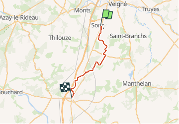

Longueur
25 km

Altitude max
133 m

Dénivelé positif
139 m
Km-Effort
27 km

Altitude min
69 m

Dénivelé négatif
163 m
Boucle
Non
Date de création :
2014-12-10 00:00:00.0
Dernière modification :
2014-12-10 00:00:00.0
6h10
Difficulté : Facile

Application GPS de randonnée GRATUITE
 SityTrail
IGN / Instituts géographiques
SityTrail Plus
Le monde est à vous
À propos
Randonnée Marche de 25 km à découvrir à Centre-Val de Loire, Indre-et-Loire, Sorigny. Cette randonnée est proposée par jeff2.
Description
Sorigny St maure de Touraine
Photos


Localisation
Pays :
France
Région :
Centre-Val de Loire
Département/Province :
Indre-et-Loire
Commune :
Sorigny
Localité :
Unknown
Départ:(Dec)
Départ:(UTM)
325445 ; 5235023 (31T) N.
Commentaires