Randonnée Trail Wattwiller - The History Ultra - Stage 1 - Photo

The History Ultra - Stage 1

 Olivier Houette
Olivier Houette

Utilisateur

© OpenStreetMap contributors
Longueur
Longueur
28 km
Altitude max
Altitude max
1186 m
Dénivelé positif
Dénivelé positif
1452 m
Km-Effort
Km-Effort  
48 km
Altitude min
Altitude min
354 m
Dénivelé négatif
Dénivelé négatif
1514 m
Boucle
Boucle
Non
Date de création :
2021-04-24 11:50:27.28
Dernière modification :
2021-04-24 11:55:57.056

(1 Avis)

Trail
Trail
--
Difficulté : Très facile

Scannez ce code QR pour ouvrir la randonnée dans l'application SityTrail

Application GPS de randonnée GRATUITE

Logo SityTrail SityTrail

IGN / Instituts géographiques

Télécharger SityTrail sur l'App Store Télécharger SityTrail sur Google Play

Logo SityTrail SityTrail World

Le monde est à vous

Télécharger SityTrail sur l'App Store Télécharger SityTrail sur Google Play Télécharger SityTrail sur Huawei AppGallery

À propos

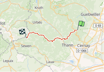
Randonnée Trail de 28 km à découvrir à Grand Est, Haut-Rhin, Wattwiller. Cette randonnée est proposée par Olivier Houette.

Description

The History Ultra - Stage 1
Start: Historial du HWK (parking)
Arrival: Ferme auberge du Neuweiher

Profil altimétrique

Localisation

Pays :
France
Région :
Grand Est
Département/Province :
Haut-Rhin
Commune :
Wattwiller
Localité :
Unknown
Départ:(UTM)
361519 ; 5302141 (32T) N.

Commentaires

Veuillez vous connecter pour laisser un commentaire ou une note


Randonnées à proximité

Randonnée Marche Soultz-Haut-Rhin - Hartmannswillerkopf - Circuit découverte - Photo
Marche
VacheKiri67

Marche

Facile
(1)
Soultz-Haut-Rhin, Grand Est, Haut-Rhin, France
3,6 km | 5,2 km-effort
1h 46min
Oui
Randonnée Marche Soultz-Haut-Rhin - Hartmannswillerkopf - Circuit anneau bleu - Photo
Marche
VacheKiri67

Marche

Moyen
(1)
Soultz-Haut-Rhin, Grand Est, Haut-Rhin, France
3,7 km | 5,9 km-effort
1h 37min
Oui
Randonnée Autre activité Steinbach - lac du ballon - Photo
Autre activité
rodabruna

Autre activité

Très facile
(1)
Steinbach, Grand Est, Haut-Rhin, France
33 km | 64 km-effort
5h 1min
Non
Randonnée A pied Goldbach-Altenbach - Firstacker - Willer sur Thur - Photo
A pied
PRO

A pied

Facile
Goldbach-Altenbach, Grand Est, Haut-Rhin, France
7,4 km | 9,6 km-effort
2h 11min
Non
Randonnée Marche Thann - JD 14/20 Thann-roche--albert--grumbachkopf - Photo
Marche
argonneuweg

Marche

Moyen
(1)
Thann, Grand Est, Haut-Rhin, France
7,6 km | 12 km-effort
2h 28min
Oui
Randonnée A pied Bitschwiller-lès-Thann - Bitschwiller les Thann - Rehbrunnel - Abri du Becherkopf - Roche Albert - Photo
A pied
patrickbeyrath

A pied

Moyen
(1)
Bitschwiller-lès-Thann, Grand Est, Haut-Rhin, France
10,3 km | 16,4 km-effort
Inconnu
Oui
Randonnée Marche Uffholtz - Molkenrain 1 - Photo
Marche
regisbodilis

Marche

Difficile
(1)
Uffholtz, Grand Est, Haut-Rhin, France
15,4 km | 26 km-effort
4h 0min
Oui
Randonnée Marche Jungholtz - Rando Retrouvailles...01/03/2024.par Jean Marc - Photo
Marche
boubou68

Marche

Très difficile
Jungholtz, Grand Est, Haut-Rhin, France
11,3 km | 19,2 km-effort
1h 35min
Oui
Randonnée Marche Steinbach - Rando CLAS du 02/11/2023 - Photo
Marche
boubou68

Marche

Très difficile
Steinbach, Grand Est, Haut-Rhin, France
17,7 km | 27 km-effort
4h 35min
Oui


Fermer
Mes abonnements